
The Cantino planisphere or Cantino world map is a manuscript Portuguese world map preserved at the Biblioteca Estense in Modena, Italy. It is named after...
18 KB (2,414 words) - 05:06, 20 October 2024
Quaresma, looking very much like Fernando de Noronha island, appears in the Cantino planisphere. The Cantino map was composed by an anonymous Portuguese...
52 KB (5,382 words) - 18:26, 30 January 2025
Early world maps (section Cantino Planisphere (1502))
given by Humboldt in his Atlas géographique et physique. The Cantino planisphere or Cantino world map is the earliest surviving map showing Portuguese discoveries...
73 KB (8,659 words) - 20:51, 7 December 2024
Treaty of Tordesillas (redirect from Tratado de Tordesillas)
line (1495–1545) marked along the Brazilian coast, from Harrisse Cantino planisphere depicting the meridian, generally considered to represent the Portuguese...
37 KB (4,408 words) - 15:00, 19 January 2025

Caverio map (category Bibliothèque nationale de France collections)
Mcintosh, Gregory C. (2022-05-04). "The Caverio Planisphere (c. 1506) Was Not Copied from the Cantino Planisphere (1502)". Terrae Incognitae. 54 (2): 110–161...
4 KB (506 words) - 20:26, 22 August 2024

Spanish Florida (section Juan Ponce de León expedition)
some time between 1500 and 1510.: 107 Furthermore, the Portuguese Cantino planisphere of 1502 and several other European maps dating from the first decade...
80 KB (9,923 words) - 20:15, 26 January 2025

Greenlanders (category CS1 German-language sources (de))
and Newfoundland. Their cartographic findings contributed to the Cantino planisphere, created in Lisbon in 1502, which accurately depicted Greenland's...
75 KB (7,532 words) - 00:31, 1 February 2025

collection of the Naval Museum in Madrid. Ancient world maps World map Cantino planisphere Davies 1976 Alves Gaspar 2017 Davies 1976 Alves Gaspar 2017 Alves...
10 KB (1,187 words) - 19:26, 15 January 2025
Bartolomeo Pareto (1455) Genoese map (1457) Map of Juan de la Cosa (1500) Cantino planisphere (1502) Piri Reis map (1513) Dieppe maps (c. 1540s-1560s)...
4 KB (372 words) - 23:00, 5 December 2022

areas, but the rhumb lines on small-scale maps such as the Teixeira planisphere were highly inaccurate. The grid can be easily spotted (as parchment...
11 KB (1,328 words) - 16:40, 11 October 2024
(1154) Catalan Atlas (1375) Early Modern age Map of Juan de la Cosa (1500) Cantino planisphere (1502) Cosmographia (Sebastian Münster) (1544) Contemporary...
2 KB (172 words) - 18:53, 29 January 2025

Mauritius (redirect from République de Maurice)
surviving map of the Portuguese discoveries dated 1502 called the Cantino planisphere, it is generally accepted that Arab sailors first discovered the...
166 KB (16,627 words) - 03:53, 1 February 2025

Discovery of Brazil (redirect from Invasão de Pindorama)
the point of arrival of Cabral's fleet. However, according to the Cantino planisphere (1502), made the year following the exploratory expedition that rescued...
39 KB (4,265 words) - 18:55, 13 January 2025

discovered lands. Even prior to Vespucci, several maps, e.g. the Cantino planisphere of 1502 and the Canerio map of 1504, placed a large open ocean between...
26 KB (3,293 words) - 16:25, 12 January 2025
(Phelsumania)[usurped] Carta del Cantino, PDF from the site of Biblioteca Estense, Modena del Cantino, Cantino planisphere image, zoomable to very high resolution...
42 KB (4,512 words) - 04:06, 21 December 2024
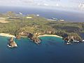
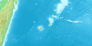
the island on the Cantino Planisphere which was purloined by the Italian diplomat/spy Alberto Cantino from Portugal in 1502. Cantino shows three islands...
41 KB (4,969 words) - 12:17, 21 November 2024

Casa da Índia (section Casa de Ceuta)
the first early world maps. The Cantino planisphere is the only existing copy of the Padrão Real. The Teixeira planisphere was made by Domingos Teixeira...
20 KB (2,423 words) - 09:50, 24 December 2024
onwards in Europeans sources. Early 16th century European maps such as Cantino planisphere, showing the knowledge of Malay Peninsula before the actual arrival...
31 KB (3,482 words) - 11:55, 6 December 2024

(1154) Catalan Atlas (1375) Early Modern age Map of Juan de la Cosa (1500) Cantino planisphere (1502) Cosmographia (Sebastian Münster) (1544) Contemporary...
2 KB (133 words) - 21:06, 12 October 2023

Catalan Atlas (redirect from Cresques planisphere)
reign of King Charles V, and is still preserved in the Bibliothèque nationale de France. The Catalan Atlas originally consisted of six vellum leaves (each...
34 KB (3,076 words) - 22:02, 24 January 2025

Name of Brazil (redirect from Terra de Santa Cruz)
the 16th century. The first hint of the new name is found in the Cantino planisphere (1502), which draws extensively on the 1501 mapping expedition. The...
16 KB (2,227 words) - 14:09, 24 January 2025

to appear. A Spanish version of the letter (presumably addressed to Luis de Santángel), was printed in Barcelona by early April 1493, and a Latin translation...
111 KB (15,131 words) - 15:02, 23 November 2024

Afonso de Albuquerque, 1st Duke of Goa (c. 1453 – 16 December 1515), was a Portuguese general, admiral, and statesman. He served as viceroy of Portuguese...
63 KB (7,625 words) - 21:46, 31 January 2025

author was not inferior to his erudition. The celestial and terrestrial planisphere of silver which he constructed for his royal patron was nearly six feet...
18 KB (2,028 words) - 13:44, 23 October 2024
These charts were rapidly reproduced, and appeared in say the 1502 Cantino planisphere. Maps from the 1590 Ain-e-Akbari, a Mughal document detailing India's...
19 KB (2,266 words) - 14:47, 28 January 2025

remain of Peter the Cruel's palace. Blanche de Bourbon was held here after her abandonment by Peter for María de Padilla in 1353. The former portal, blocked...
13 KB (1,422 words) - 18:12, 1 September 2024
a new world. Another form of this peninsula appeared in the 1502 Cantino planisphere smuggled out of Portugal for the Duke of Ferrara. The map has lost...
14 KB (1,337 words) - 00:15, 12 January 2025

Nicolau Coelho, Sancho de Tovar, Simão de Miranda, Aires Gomes da Silva, Vasco de Ataíde, Diogo Dias, Simão de Pina, Luís Pires, Pêro de Ataíde and Nuno Leitão...
23 KB (2,852 words) - 10:04, 15 December 2024

João Fernandes Labrador in 1499 or 1500. Seen as claimed in the Cantino planisphere of 1502, Reinel-Lopo Homem chart of 1519 and Reinel map of 1535....
25 KB (3,002 words) - 00:50, 20 January 2025

Portuguese expeditions to North America (section First Expedition by João Fernandes Lavrador and Pêro de Barcelos)
they could have taken place as late as 1500–1501. Evidence from the Cantino Planisphere of 1502 indicates that Portuguese explorers, possibly including Fernandes...
11 KB (1,180 words) - 22:26, 31 January 2025