
The Rural Municipality of Coalfields No. 4 (2016 population: 368) is a rural municipality (RM) in the Canadian province of Saskatchewan within Census Division...
13 KB (652 words) - 10:49, 29 December 2023
North Portal (category Coalfields No. 4, Saskatchewan)
village in the Canadian province of Saskatchewan within the Rural Municipality of Coalfields No. 4 and Census Division No. 1. It is adjacent to the Canada–United...
10 KB (453 words) - 20:19, 31 May 2024

A rural municipality (RM) is a type of incorporated municipality in the Canadian province of Saskatchewan. A rural municipality is created by the Minister...
126 KB (354 words) - 07:55, 12 April 2024

Frobisher, Saskatchewan (category Coalfields No. 4, Saskatchewan)
Canadian province of Saskatchewan within the Rural Municipality of Coalfields No. 4 and Census Division No. 1. It has an elevation of 576 metres (1,891...
12 KB (640 words) - 01:51, 4 July 2024
of NTPC were expected to improve. Simlong and Chatkam collieries and other nearby collieries of Rajmahal coalfield are operated by Eastern Coalfields...
14 KB (755 words) - 22:22, 30 April 2024
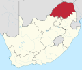
Limpopo (redirect from Economy of Limpopo)
extension of Botswana's Mmamabula coalfields, is estimated to contain 40% of South Africa's coal reserves. The Limpopo Department of Economic Development, Environment...
28 KB (2,218 words) - 03:07, 11 July 2024

Giridih (redirect from Economy of Giridih)
the Giridih Coalfield which is one of the oldest coalfields to be worked in India. Giridih is one of the six Data Processing Centres of Data Processing...
33 KB (2,670 words) - 11:35, 18 June 2024

shaded in the map. A major part of the North Karanpura Area and some fringe areas of the Piparwar Area of the Central Coalfields Limited, both located in the...
18 KB (932 words) - 00:31, 16 March 2024
Paschim Bardhaman district (category Pages using infobox settlement with no coordinates)
History. CIL. Archived from the original on 4 February 2018. Retrieved 4 March 2017. "Eastern Coalfields aim higher output from underground mining". The...
41 KB (3,564 words) - 22:16, 4 July 2024

Dankuni is a city and a municipality of Hooghly district in the Indian state of West Bengal. It is now part of the area covered by Kolkata Metropolitan...
32 KB (2,674 words) - 11:09, 26 January 2024

area is the Rural Municipality of Hudson Bay No. 394 at 12,399.12 km2 (4,787.33 sq mi), while the smallest by land area is the Resort Village of Greig Lake...
256 KB (2,016 words) - 21:31, 6 January 2024

2018. "Sonepur Bazari Area". Eastern Coalfields Limited. Retrieved 16 January 2017. "Planning". Eastern Coalfields Limited. Retrieved 30 January 2017....
26 KB (2,370 words) - 15:07, 19 May 2023
Lephalale (category Populated places in the Lephalale Local Municipality)
is a coal mining town in the Limpopo province of South Africa immediately east of the Waterberg Coalfield. The town was established as Ellisras in 1960...
24 KB (2,986 words) - 13:08, 8 July 2024

Durgapur subdivision (category Subdivisions of West Bengal)
October 2016. "Sonepur Bazari Area". Eastern Coalfields Limited. Retrieved 5 March 2017. "Eastern Coalfields aim higher output from underground mining"...
46 KB (2,485 words) - 05:22, 17 February 2024
This article is a list of historic places in rural municipalities of the province of Saskatchewan entered on the Canadian Register of Historic Places, whether...
88 KB (75 words) - 23:26, 23 October 2023
SARM Division No. 1 is a division of the Saskatchewan Association of Rural Municipalities (SARM) within the Canadian province of Saskatchewan. It is located...
4 KB (311 words) - 15:15, 28 October 2023

A village is a type of incorporated municipality within the majority of the provinces and territories of Canada. As of January 1, 2012, there were 550...
9 KB (1,069 words) - 21:49, 8 December 2023

Asansol Sadar subdivision (category Subdivisions of West Bengal)
coal mines. In 2015–16, Eastern Coalfields, a subsidiary of Coal India, produced 40.209 million tonnes of raw coal. As of January 2017, it employed 64,433...
48 KB (2,762 words) - 03:39, 11 September 2023
shaded in the map. A major part of the North Karanpura Area and some fringe areas of the Piparwar Area of the Central Coalfields Limited, both located in the...
21 KB (1,251 words) - 20:55, 8 March 2024

Öndörkhaan (category Districts of Khentii Province)
−40 °F without the subtraction of wind chill. Coal mining is important to the economy of the town and Chandgana Tal coalfield is located 53 km W from Öndörkhaan...
10 KB (350 words) - 03:38, 7 April 2024
operational areas of Central Coalfields spread across South Karanpura Coalfield, Ramgarh Coalfield and West Bokaro Coalfield. Four of the six CD blocks in the...
14 KB (669 words) - 15:39, 2 November 2023
Roche Percee (category Coalfields No. 4, Saskatchewan)
is a village in the Canadian province of Saskatchewan within the RM of Coalfields No. 4 and Census Division No. 1. The village is near the Canada–United...
11 KB (731 words) - 00:15, 27 May 2024
Project" (PDF). Central Coalfields Limited. Retrieved 15 January 2021. "Central Coalfields invites bids for operationalisation of Sanghamitra OCP". Projects...
13 KB (640 words) - 06:20, 25 May 2022

the Damodar River, about 130 miles (210 km) above the point of confluence. It is only 64.4 kilometres (40.0 mi) from its source. At the point where the...
10 KB (659 words) - 16:22, 2 February 2024

Appalachia (redirect from History of Appalachia)
region. Railroad construction gave the greater nation access to the vast coalfields in central Appalachia, making its economy greatly dependent on coal mining...
137 KB (14,846 words) - 01:19, 8 July 2024

Bilaspur, Chhattisgarh (redirect from History of Bilaspur, Chhattisgarh)
Bilaspur Railway Division. Bilaspur is also the headquarters of South Eastern Coalfields Limited. Chhattisgarh's biggest power plant operated by NTPC...
52 KB (5,457 words) - 11:17, 25 June 2024
Satgram Area of Eastern Coalfields has a mineable reserve of 8.70 million tonnes. Damalia open cast project in Satgram Area of Eastern Coalfields has a mineable...
26 KB (2,527 words) - 10:15, 30 April 2024
Area is one of the operational areas of the Central Coalfields Limited located mainly in the Hazaribagh and Ramgarh districts in the state of Jharkhand...
19 KB (1,114 words) - 19:17, 31 October 2023
Mugma Area is one of the 14 operational areas of Eastern Coalfields Limited located in Dhanbad district in the state of Jharkhand, India. 3km 2miles Reservoir...
20 KB (1,861 words) - 17:24, 15 February 2023

Ube, Yamaguchi (section Neighbouring municipalities)
the south was reclaimed by seabed coalfields, and the place names such as 'Unoshima' and 'Hamacho' are remnants of this. A gentle mountainous area spreads...
17 KB (1,286 words) - 23:57, 1 June 2024