The Depsang Plains, a high-altitude gravelly plain in the northwest portion of the disputed Aksai Chin region of Kashmir, divided into Indian and Chinese...
56 KB (5,011 words) - 21:11, 4 April 2024

(Russia) Bhuikhel (Nepal) Depsang Plains (India and China) Dooars (India and Bhutan) Eastern coastal plains (India) Indo-Gangetic Plains (Bangladesh, India,...
17 KB (1,639 words) - 20:57, 10 April 2024
stream, Raki Nala, flows down from the Depsang Plains and hence, connects the Depsang Bulge to the Depsang Plains. The southern stream connects it to the...
38 KB (4,639 words) - 02:20, 12 July 2024
officer, India lost access to 26 of 65 patrolling points (PP 5–17 in Depsang Plains & Depsang Bulge including Samar Lungpa & Galwan, 24-32 in Changchenmo basin...
52 KB (4,933 words) - 07:39, 27 July 2024

Aksai Chin (redirect from Soda Plains)
Demchok sector Depsang Plains Ladakh List of locations in Aksai Chin Nelang Rutog County Shaksgam Valley Trans-Karakoram Tract 2013 Depsang standoff The...
65 KB (7,103 words) - 03:33, 10 August 2024

Ladakh, India. The westernmost population of Tibetan antelope is in Depsang Plains, where they are found at altitudes of up to 5500 m. Today, the majority...
24 KB (2,724 words) - 05:51, 16 May 2024

Chin. Depsang plains (Karakoram Plains), north of Karakoram range. Daulat Beg Oldie Depsang Bulge Lingzi Thang Plains, southeast of Depsang plains & north...
33 KB (3,646 words) - 05:14, 30 July 2024

The 2013 Depsang standoff, also called 2013 Depsang incursion, or 2013 Daulat Beg Oldi incident, was an incursion and sit-in by a platoon-sized contingent...
19 KB (1,672 words) - 04:55, 20 March 2024
Pass, Khunjerab Pass, then India-held Aghil Pass north of K2. Then in Depsang Plains in Ladakh, passes with Aksai Chin from northwest to southeast are Karakoram...
15 KB (52 words) - 14:10, 10 June 2024

Nala Shyok River Chip Chap Chip Chap River DEPSANG PLAINS Sultan Chhushku Murgo Burtsa Qizil Langar Depsang La Gapshan Tianwendian DBO Karakoram Pass ...
45 KB (3,906 words) - 21:46, 25 July 2024
Travelling south from the pass involved three days' march across the barren Depsang Plains at about 5,300 m (17,400 ft). To the north, the country was somewhat...
10 KB (902 words) - 10:59, 12 April 2024

from the encampment by China's People's Liberation Army on Ladakh's Depsang Plains, threatening to cancel Premier Li Keqiang's scheduled visit to India...
42 KB (3,299 words) - 06:50, 14 August 2024
part of Xinjiang). The region is roughly equivalent to the portion of Depsang Plains under Chinese control. Its headquarters, the Tianwendian outpost, is...
12 KB (1,191 words) - 19:29, 15 July 2023
It originates at the eastern edge of the Depsang Plains and flows west, skirting around the Depsang Plains in the north. It discharges into the Shyok...
13 KB (1,102 words) - 16:52, 1 May 2023

2020–2021 China–India skirmishes (section Depsang area)
troops from all key areas including Pangong Tso, Galwan Valley and the Depsang plains and the restoration of status quo ante in April whereas China emphasised...
382 KB (31,206 words) - 21:38, 13 August 2024
the east side of the range, the upper Shyok River divides it from the Depsang Plains, part of the Tibetan Plateau. On the southeast, the pass known as the...
4 KB (375 words) - 21:38, 19 June 2024

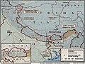
confirmed when the road was shown in Chinese maps published in 1958. The Depsang Plains are located on the border of the Indian union territory of Ladakh and...
50 KB (4,867 words) - 23:54, 13 August 2024

Tang (NI44-1, LQ1) Chorten Tang (NI44-1, KQ4) Depsang Plains Lingzi Tāng (Lingzhithang, Lingzhithāng Plains, Ling-shi-tang) (NI44-5, LP2) (林格季唐凹地; 林济塘洼地)...
21 KB (2,001 words) - 23:32, 21 May 2024

is presently the operational border between India and the PRC. The Depsang Plains are located on the border of the Indian union territory of Ladakh and...
40 KB (3,656 words) - 00:20, 19 June 2024
Face-off (2014), Introduction: "Some 500 km from the 17,000 feet high plains of Depsang, the Indian Army constructed a tin shed to cover a point known as...
19 KB (1,901 words) - 20:16, 9 August 2024
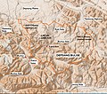
Shyok River Chip Chap Chip Chap River DEPSANG PLAINS Heweitan Sultan Chhushku Murgo Burtsa Qizil Langar Depsang La Gapshan Tianwendian DBO Karakoram Pass...
17 KB (637 words) - 05:34, 5 August 2023
Brangsa. From here, the joint route followed Burtsa Nala and Depsang Nala to reach the Depsang Plains and went on to the Karakoram Pass via Daulat Beg Oldi....
24 KB (1,635 words) - 10:04, 31 October 2023

Road-DBO Tunnel (SSSG-DBO tunnel, Saser La - Saser Brangsa Tunnel) Depsang Plains Ladakh ? km N (DPR) 2027? (?) Road On Sasoma–Sasser La-Saser Brangsa-Gapsam-Daulat...
87 KB (5,294 words) - 07:10, 24 May 2024
↓Border talks resume ↓Nathu La/Cho La ↓Sumdorong Chu ↓Doklam ↓Galwan ↓Depsang ↓1962 war Major border events: ↓Tulung La Indian PM: Nehru Indira Gandhi...
110 KB (9,594 words) - 23:53, 13 August 2024
and run along the western bank of the Shyok River and then move on to Depsang Plains near Murgo. The initial road did not meet the all-weather requirement...
68 KB (6,697 words) - 04:12, 19 December 2023
point))." Kondapalli, Srikanth (6 May 2013). "The fallout of China's Depsang plains transgression - Rediff.com India News". Rediff News. Retrieved 20 April...
21 KB (2,085 words) - 21:27, 16 April 2024
Leopard and fully deployed at Daulat Beg Oldi, on the Karakoram Pass-Depsang Plains alignment at an altitude of 16,800 feet. Indo-Pakistan War of 1971 Battle...
10 KB (719 words) - 10:53, 30 January 2024

2015. Tianwendian, a Chinese military camp is on the Chinese side near Depsang Plains in the region of Aksai Chin, an area controlled by China but claimed...
19 KB (1,763 words) - 22:56, 5 June 2024

Treaty of Nerchinsk of 1689. Abkhazia Abkhazia Georgia Aksai Chin and Depsang Plains China Republic of China India Arunachal Pradesh India China Republic...
169 KB (4,398 words) - 07:03, 15 August 2024

Khanate demolished it. Remnants can still be seen. Murgo has Depsang Plains in the north, Depsang Bulge (Burtsa Bulge) in the east, Chang Chenmo River in the...
14 KB (1,209 words) - 07:51, 30 October 2023