Eureka County is a county in the U.S. state of Nevada. As of the 2020 census, the population was 1,855, making it the second-least populous county in Nevada...
15 KB (1,218 words) - 13:46, 26 April 2024

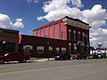
Eureka is an unincorporated town and census-designated place in and the county seat of Eureka County, Nevada, United States. With a population of 414 as...
18 KB (1,255 words) - 14:34, 15 August 2024

26, 2009. Eureka County. "Eureka Opera House". Eureka County. Archived from the original on March 16, 2008. Retrieved March 13, 2008. Nevada Commission...
59 KB (4,908 words) - 08:33, 18 August 2024

Eureka Airport (IATA: EUE, FAA LID: Ø5U) is seven miles northwest of Eureka, in Eureka County, Nevada, United States. It is owned by the County of Eureka...
5 KB (353 words) - 13:43, 13 August 2023

(originally called Palisades) is located in Eureka County in the northeastern section of the state of Nevada, in the western United States. It is about...
8 KB (666 words) - 14:44, 15 August 2024
Perry County, Missouri Eureka, Montana Eureka, Nevada Eureka, North Carolina Eureka, Oregon, an unincorporated community and ghost town Eureka, Pennsylvania...
8 KB (898 words) - 05:04, 30 May 2024

Beowawe (/ˌbeɪoʊˈwɑːˌwiː/ bay-ə-WAH-wee) is a small town in Eureka County, Nevada, United States. The community is the site of a mining operation and...
12 KB (831 words) - 14:10, 15 August 2024

Douglas County, Eureka County, Lincoln County, Pershing County and Washoe County (which contains Reno) ban brothels. The other ten counties permit brothels...
68 KB (7,239 words) - 06:30, 15 August 2024

Valley is a census-designated place (CDP) in Eureka County, Nevada, United States, directly off Nevada State Route 306. It is the site of Crescent Valley...
9 KB (590 words) - 14:15, 15 August 2024
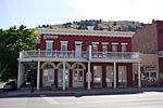
Eureka Historic District is a historic district in Eureka, Nevada, United States, that is listed on the National Register of Historic Places. Of the many...
7 KB (728 words) - 21:12, 21 September 2024

Humboldt–Toiyabe National Forest (category Protected areas of Eureka County, Nevada)
southern Nevada and eastern California, in parts of Nye, Lander, Mineral, Lyon, Eureka, Washoe, Douglas, and Clark counties, and Carson City in Nevada, as...
12 KB (855 words) - 11:45, 1 October 2024
County, all of Churchill, Douglas, Elko, Eureka, Humboldt, Lander, Pershing, Storey, Washoe, and White Pine counties, as well as the state capital, Carson...
44 KB (789 words) - 15:29, 22 September 2024

central Nevada, the Western United States. The valley is almost entirely within Eureka County, but the northern end crosses into Elko County. The valley...
6 KB (211 words) - 13:32, 15 November 2023
Lone Mountain is a summit in the U.S. state of Nevada. The elevation is 7,864 feet (2,397 m). Lone Mountain was so named on account of its isolated location...
805 bytes (83 words) - 15:00, 29 July 2024

topographically prominent mountain in both the Diamond Mountains and Eureka County, in Nevada, United States. It ranks thirty-ninth among the most topographically...
3 KB (156 words) - 08:22, 14 March 2024

mountain pass in Eureka County, Nevada, United States. It originally carried the California Trail over the Emigrant Hills of northern Eureka County, reaching...
2 KB (99 words) - 16:32, 26 October 2023
South Hill is a summit in the U.S. state of Nevada. The elevation is 7,264 feet (2,214 m). South Hill was named for the fact it is south of other nearby...
697 bytes (79 words) - 21:36, 21 October 2020

presidential candidate carried Nevada, and the last until 2008 in which the party received a majority of the vote. Eureka Ormsby Washoe United States presidential...
12 KB (248 words) - 17:59, 28 September 2024

ghost town in Eureka County, in the central part of the U.S. state of Nevada, approximately 2.6 mi (4.2 km) west of the town of Eureka, Nevada. In 1910, the...
7 KB (750 words) - 21:55, 18 September 2023

1939 City of San Francisco derailment (redirect from Harney, Nevada)
August 12, 1939, the City of San Francisco train derailed outside of Harney, Nevada, United States, killing 24 and injuring 121 passengers and crew. The derailment...
12 KB (1,140 words) - 04:45, 4 August 2024

Goldstrike mine (category Buildings and structures in Eureka County, Nevada)
Goldstrike is a gold mine in Eureka County in north-eastern Nevada. It is located on the Carlin Trend, a prolific gold mining district. It is owned and...
7 KB (706 words) - 08:50, 12 June 2024

There are 16 counties and one independent city in the U.S. state of Nevada. On November 25, 1861, the first Nevada Territorial Legislature established...
10 KB (376 words) - 23:26, 19 April 2024
Information System: Grass Valley (Eureka and Lander counties, Nevada) Federal Writers' Project (1941). Origin of Place Names: Nevada (PDF). W.P.A. p. 41. 39°51′42″N...
667 bytes (78 words) - 21:30, 21 October 2020

Eureka Opera House is an auditorium and convention center in Eureka, Nevada. Built in 1880, it has remained an important center of town activities. The...
5 KB (314 words) - 00:17, 30 November 2021

Retrieved March 7, 2019. "Eureka County Title 6 County Code" (PDF). Eureka County Nevada. Retrieved May 5, 2018. "Humboldt County Code". www.codepublishing...
54 KB (5,264 words) - 07:14, 8 July 2024

Interstate 80 (I-80) traverses the northern portion of the US state of Nevada. The freeway serves the Reno metropolitan area and passes through the towns...
32 KB (1,625 words) - 00:59, 5 August 2024
The Elko Micropolitan Statistical Area is a two county (Elko, Eureka) Nevada statistical area of 21,383 sq mi (55,380 km2). The area includes portions...
4 KB (225 words) - 01:46, 11 May 2024
place located in Eureka County, Nevada. At its peak in 1874 and 1875, it had a hotel and several saloons. The town was served by the Eureka and Palisade Railroad...
2 KB (117 words) - 04:49, 18 December 2023
Cortez Gold Mine (category Buildings and structures in Eureka County, Nevada)
Mine is a large gold mining and processing facility in Lander and Eureka County, Nevada, United States, located approximately 63 miles (100 km) southwest...
13 KB (1,501 words) - 17:01, 22 September 2023
Eureka County School District (ECSD) is a school district headquartered in Eureka, Nevada. It covers Eureka County. Greg Wieman was the superintendent...
4 KB (397 words) - 18:27, 14 April 2024