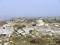
Heritage Centre Fforest Fawr Geopark is a Geopark in the Brecon Beacons National Park, south Wales. It is the first designated Geopark in Wales having...
12 KB (1,368 words) - 23:16, 4 August 2024

Fforest Fawr (Welsh pronunciation: [ˌfɔrɛst ˈvau̯r], transl. "Great Forest") is an extensive upland area in the county of Powys, Wales. Formerly known...
8 KB (1,099 words) - 17:51, 10 April 2024

Black Mountain (range) (section Llyn y Fan Fawr)
metres or 2,631 ft. The Black Mountain also forms a part of the Fforest Fawr Geopark. The Black Mountain should not be confused with the Black Mountains...
13 KB (1,806 words) - 22:12, 12 January 2024

and global status in 2005 as Fforest Fawr Geopark, which includes the Black Mountain, the historic extent of Fforest Fawr, and much of the Brecon Beacons...
37 KB (3,606 words) - 11:08, 18 June 2024

late-glacial moraine. The mountain is the highest point within the Fforest Fawr Geopark which was established in 2005 to promote economic development, particularly...
17 KB (1,800 words) - 22:57, 24 July 2024
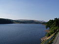
south Wales. It lies within the Brecon Beacons National Park and Fforest Fawr Geopark. The 110 ft high embankment has, since its completion in 1927, been...
4 KB (351 words) - 11:50, 10 February 2024
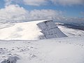
is a subsidiary summit of Fan Brycheiniog. Picws Du falls within Fforest Fawr Geopark and its prominent summit is marked by a large Bronze Age round barrow...
9 KB (1,199 words) - 06:58, 30 July 2024

Wales – Llyn Clywedog". Retrieved 20 September 2015. "Reservoirs". Fforest Fawr Geopark. 2011. "International Association for Coastal Reservoir Research"...
52 KB (5,675 words) - 00:37, 22 July 2024
neighbouring county of Carmarthenshire. Fan Brycheiniog is also within the Fforest Fawr Geopark designated in 2005 in recognition of the area's geological heritage...
10 KB (1,172 words) - 01:38, 2 April 2024

Global Geoparks (UGGp) are geoparks certified by the UNESCO Global Geoparks Council as meeting all the requirements for belonging to the Global Geoparks Network...
38 KB (2,199 words) - 10:24, 30 July 2024

centuries, the odd situation now arises where Fforest Fach now finds itself within Fforest Fawr Geopark, the boundaries of which are drawn rather more...
3 KB (364 words) - 18:37, 16 July 2023

well-known landforms. The west of the park is also designated as Fforest Fawr Geopark in recognition of its geological interest, and includes Waterfall...
64 KB (6,913 words) - 04:48, 5 August 2024

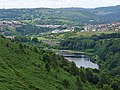
its course it flows through the Brecon Beacons National Park and Fforest Fawr Geopark. The river rises on the northern slopes of the Black Mountain and...
3 KB (352 words) - 00:09, 14 July 2023
Fawr is a hill in the northern corner of the county borough of Rhondda Cynon Taf, Wales. It lies within the Brecon Beacons National Park and Fforest Fawr...
3 KB (496 words) - 18:32, 16 July 2023
Abercraf (category Fforest Fawr)
outside the boundaries of the Brecon Beacons National Park and the Fforest Fawr Geopark, which lie to the immediate north, east, and west of the village...
4 KB (547 words) - 04:00, 19 April 2024

Llandovery lies just north of Brecon Beacons National Park and Fforest Fawr Geopark, whose geological heritage is celebrated. These designated landscapes...
14 KB (1,612 words) - 21:53, 18 July 2024
Dinas Rock (category Fforest Fawr)
Dinas Rock lies within the Brecon Beacons National Park and the Fforest Fawr Geopark. It is owned by Natural Resources Wales, who manage it for its wildlife...
6 KB (799 words) - 18:34, 16 July 2023

popular attraction for visitors. A part of Tawe-Uchaf lies within Fforest Fawr Geopark and the Brecon Beacons National Park. A complex of Bronze Age monuments...
3 KB (318 words) - 14:06, 16 February 2024

southwest Wales. It lies within the Brecon Beacons National Park and Fforest Fawr Geopark. Its plateau-like summit attains a height of 602 metres (1,975 ft)...
3 KB (275 words) - 19:32, 16 July 2023
running to Dolygaer (though there are plans to extend it further). The Fforest Fawr Geopark, designated in 2005 in respect of the area's outstanding geological...
49 KB (5,059 words) - 22:46, 6 August 2024

the Black Mountain range of the Brecon Beacons National Park and Fforest Fawr Geopark. Its summit is plateau-like and reaches a height of 412m at OS grid...
3 KB (324 words) - 00:16, 14 July 2023
Harz – Braunschweiger Land – Ostfalen Hateg Country Dinosaurs Beigua Fforest-Fawr Bohemian Paradise Cabo de Gata-Nijar Naturtejo Sierras Subbéticas Sobrarbe-Pirineos...
17 KB (951 words) - 05:17, 2 October 2021
Penmoelallt (category Fforest Fawr)
south Wales. It lies within the Brecon Beacons National Park and Fforest Fawr Geopark. To its east lies the deep valley of Cwm Taf and to its north a rather...
4 KB (501 words) - 18:38, 16 July 2023

at the western extremity of the Brecon Beacons National Park and Fforest Fawr Geopark. Its summit at 283 metres (928 ft) is towards the eastern end of...
3 KB (388 words) - 23:35, 9 August 2023
2020-01-29. "Fforest Fawr | United Nations Educational, Scientific and Cultural Organization". unesco.org. Retrieved 2020-01-29. "Fforest Fawr | UNESCO Global...
63 KB (2,617 words) - 08:51, 21 November 2023

well-known landforms. The west of the park is also designated as Fforest Fawr Geopark in recognition of its geological interest, and includes Waterfall...
17 KB (1,749 words) - 11:50, 13 March 2024
Carreg Cadno (category Fforest Fawr)
south Wales. It lies within the Brecon Beacons National Park and Fforest Fawr Geopark. Its summit at OS grid ref SN 874161 reaches a height of 538m / 1763 ft...
3 KB (428 words) - 18:33, 16 July 2023

it lies partly or wholly within Brecon Beacons National Park and Fforest Fawr Geopark. Wikimedia Commons has media related to River Honddu (Usk). Owen...
2 KB (261 words) - 18:22, 4 September 2021

Historical Monuments of Wales. Retrieved 17 November 2012. "Iron Age". Fforest Fawr Geopark. Retrieved 17 November 2012. Samuel Lewis (1845). A topographical...
5 KB (456 words) - 23:57, 13 July 2023