name of "Los Reyes de Salgado, Michoacán." Michoacán Archived 2011-05-17 at the Wayback Machine Enciclopedia de los Municipios de México. Retrieved on...
3 KB (293 words) - 04:54, 4 June 2024
Churumuco (redirect from Churumuco de Morelos, Michoacán)
Instituto Nacional de Estadística y Geografía. 2010. Archived from the original on December 20, 2010. Retrieved September 4, 2012. Michoacán Archived May 17...
6 KB (233 words) - 15:37, 30 August 2024
central Mexican state of Michoacán. As of 2010, the town had a population of 3,689. Instituto Nacional de Estadística y Geografía. Principales resultados...
5 KB (60 words) - 22:23, 9 August 2020

Zamora, Michoacán. Link to tables of population data from Census of 2010 INEGI: Instituto Nacional de Estadística, Geografía e Informática] Michoacán Enciclopedia...
20 KB (1,670 words) - 02:01, 12 September 2024

port city in Michoacán bordered to the east by Guerrero. Lázaro Cárdenas is located in the southern part of the Mexican state of Michoacán. It was formerly...
8 KB (617 words) - 03:45, 15 August 2024

central Mexican state of Michoacán. As of 2010, the town had a population of 3,799. Instituto Nacional de Estadística y Geografía. Principales resultados...
5 KB (61 words) - 05:59, 23 August 2024

La Piedad (redirect from La Piedad, Michoacán)
Instituto Nacional de Estadística, Geografía e Informática Michoacán Enciclopedia de los Municipios de México La Piedad Ayuntamiento de La Piedad Official...
11 KB (1,306 words) - 17:35, 24 April 2024

Queréndaro (redirect from Querendaro Michoacan de Ocampo)
Estado de Michoacán (1993). El Rumbo es Michoacán. p. 155. Información proporcionada por cada uno de los H. Ayuntamientos del Estado de Michoacán, 1996-1998...
7 KB (990 words) - 06:10, 13 April 2024

Apatzingán (redirect from Apatzingan, Michoacán)
Census of 2005 Instituto Nacional de Estadística, Geografía e Informática (INEGI) Michoacán Enciclopedia de los Municipios de México " Photograph from Apatzingan's...
10 KB (361 words) - 18:32, 28 September 2024
Instituto Nacional de Estadística, Geografía e Informática. Archived from the original on 2013-04-06. Retrieved 2007-10-08. Aguililla, Michoacán Archived 2007-12-14...
2 KB (207 words) - 06:33, 9 February 2024
Nacional de Estadística y Geografía. 2010. Archived from the original on 20 April 2011. Retrieved 4 September 2012. "Datos Viales de Michoacán" (PDF) (in...
5 KB (211 words) - 16:54, 18 May 2024

Zacapu (redirect from Zacapu, Michoacán)
INEGI: Instituto Nacional de Estadística, Geografía e Informática (in Spanish). INEGI: Instituto Nacional de Estadística, Geografía e Informática. Retrieved...
2 KB (248 words) - 04:56, 24 July 2022

Sahuayo (redirect from Sahuayo de Morelos, Michoacán)
of 2005 INEGI: Instituto Nacional de Estadística, Geografía e Informática Michoacán Enciclopedia de los Municipios de México Negotiating Extra-Territorial...
8 KB (650 words) - 02:17, 10 June 2024
Coahuayana (redirect from Coahuayana, Michoacán)
de Estadística, Geografía e Informática. Archived from the original on 2013-04-06. Retrieved 2007-10-08. Cultura y Magia en las narraciones orales de...
2 KB (179 words) - 06:31, 9 February 2024
of the state of Querétaro de Arteaga. Michoacán Archived 2011-05-17 at the Wayback Machine Enciclopedia de Los Municipios de México. Retrieved on October...
2 KB (196 words) - 08:10, 15 August 2024
Taretan (redirect from Taretan, Michoacán)
Instituto Nacional de Estadística, Geografía e Informática. Archived from the original on 2013-04-06. Retrieved 2007-10-07. "MICHOACÁN". portales.sre.gob...
2 KB (172 words) - 13:31, 3 October 2024

Angamacutiro (redirect from Angamacutiro de la Unión)
"Michoacán. Población total por municipio según grandes grupos de edad, 2005" (in Spanish). Instituto Nacional de Estadística y Geografía. "Michoacán....
8 KB (760 words) - 13:14, 1 February 2024

Cotija is a municipality in the Mexican state of Michoacán. The municipality has an area of 504.05 km2 (0.91% of the surface of the state), and is bordered...
6 KB (614 words) - 18:04, 15 June 2024
Reuters. 2022-03-28. Retrieved 2022-03-28. Instituto Nacional de Estadística y Geografía (2010). "Principales resultados por localidad 2010 (ITER)". "Gunmen...
5 KB (95 words) - 12:34, 15 August 2024

Zitácuaro (redirect from Zitácuaro, Michoacán)
INEGI: Instituto Nacional de Estadística, Geografía e Informática Michoacán Enciclopedia de los Municipios de México Ayuntamiento de Zitácuaro Official website...
9 KB (1,095 words) - 01:41, 10 May 2024
Jungapeo (redirect from Jungapeo, Michoacán)
2007-10-16 at the Wayback Machine Michoacán Archived 2011-05-17 at the Wayback Machine Enciclopedia de los Municipios de México. Retrieved on October 6,...
2 KB (178 words) - 06:53, 9 February 2024
Tumbiscatío (redirect from Tumbiscatío, Michoacán)
is the city of Tumbiscatío de Ruiz. Michoacán Archived 2011-05-17 at the Wayback Machine Enciclopedia de los Municipios de México. Retrieved on October...
2 KB (151 words) - 23:20, 28 June 2022
Tancítaro (redirect from Tancítaro, Michoacán)
is a city and municipality in the western part of the Mexican state of Michoacán, in southwestern Mexico. Its municipal seat is the City of Tancítaro....
5 KB (459 words) - 02:26, 22 May 2024
district of Michoacán (Distrito electoral federal 13 de Michoacán) is a defunct federal electoral district of the Mexican state of Michoacán. During its...
15 KB (810 words) - 03:02, 31 August 2024

district of Michoacán (Distrito electoral federal 12 de Michoacán) is a defunct federal electoral district of the Mexican state of Michoacán. During its...
20 KB (1,094 words) - 22:11, 30 August 2024
Tarímbaro (redirect from Tarimbaro, Michoacan)
Tarímbaro is a municipality in the Mexican state of Michoacán. The municipality has an area of 258.57 square kilometres (0.43% of the surface of the state)...
2 KB (255 words) - 21:34, 30 August 2024
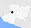
Ario Municipality (redirect from Ario, Michoacán)
Ario is a municipality in the Mexican state of Michoacán. The municipality has an area of 694.60 square kilometres (1.18% of the surface of the state)...
2 KB (223 words) - 11:43, 8 February 2024
Uruapan (redirect from Uruapan, Michoacán)
Enciclopedia de Los Municipios y Delegaciones de México Estado de Michoacán de Ocampo. INAFED. Retrieved April 5, 2015. "Atractivos". State of Michoacán. Retrieved...
27 KB (2,699 words) - 00:52, 10 March 2024
Susupuato (redirect from Susupuato, Michoacán)
Enciclopedia de los Municipios de México. Retrieved on October 6, 2007 "2005 Census". INEGI: Instituto Nacional de Estadística, Geografía e Informática...
2 KB (154 words) - 14:37, 10 February 2024
Charo Municipality (redirect from Charo, Michoacán)
Charo is a municipality located in the Mexican state of Michoacán. The municipality has an area of 322.50 square kilometres (0.29% of the surface of the...
2 KB (183 words) - 18:00, 28 June 2022