section of coast west of the Okotuso well, Kunene Region Wikimedia Commons has media related to Geography of Namibia. Namibia Towns in Namibia List of rivers...
37 KB (2,838 words) - 02:33, 8 May 2024

Cities and towns in Namibia are distinguished by the status the Government of Namibia has vested in them: Places in Namibia that are governed by a municipality...
9 KB (411 words) - 14:57, 4 June 2024

Namibia (/nəˈmɪbiə/ , /næˈ-/), officially the Republic of Namibia, is a country in Southern Africa. Its western border is the Atlantic Ocean. It shares...
175 KB (16,400 words) - 08:17, 28 June 2024
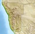
See ISO 3166-2:NA Internet country code top-level domain: .na Geography of Namibia Namibia is: a sub-Saharan country Location: Eastern Hemisphere and Southern...
13 KB (827 words) - 13:15, 30 October 2023
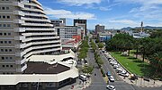
Windhoek (redirect from Capital of Namibia)
German: [ˈvɪnthʊk] ) is the capital and largest city of Namibia. It is located in central Namibia in the Khomas Highland plateau area, at around 1,700 m...
54 KB (4,454 words) - 13:00, 18 June 2024
White Namibians (German: Weiße Namibier or Europäische Namibier) are people of European descent settled in Namibia. The majority of White Namibians are...
10 KB (720 words) - 23:11, 28 June 2024

Hoba meteorite (category Geography of Namibia)
far from Grootfontein, in the Otjozondjupa Region of Namibia. It has been uncovered, but because of its large mass, has never been moved from where it...
10 KB (1,113 words) - 08:43, 13 June 2024

and sanitation in Namibia Effects of climate change Economy of Namibia Agriculture in Namibia Geography of Namibia Health in Namibia "World Bank Climate...
29 KB (2,523 words) - 11:12, 17 June 2024

Deadvlei (category Geography of Namibia)
located near the more famous salt pan of Sossusvlei, in a valley between the dunes in the Namib-Naukluft Park in Namibia. Also written DeadVlei or Dead Vlei...
4 KB (546 words) - 00:59, 11 January 2024
Erongo Region Etosha National Park Frankie Fredericks Fransfontein Geography of Namibia German colonisation German South-West Africa Gobabis Grootfontein...
4 KB (322 words) - 08:03, 9 April 2024

Namaqualand (category Geography of Namibia)
is an arid region of Namibia and South Africa, extending along the west coast over 1,000 km (600 mi) and covering a total area of 440,000 km2 (170,000 sq mi)...
8 KB (853 words) - 21:51, 25 June 2024

over. Since then, demarcations and numbers of regions and constituencies of Namibia are tabled by delimitation commissions and accepted or declined by the...
5 KB (205 words) - 14:36, 29 June 2024

regulations of South Africa when it gained independence in 1990. Triggered by fears for children walking to school before sunrise, in 1993 the Namibian Time...
7 KB (818 words) - 23:20, 10 June 2024

The protected areas of Namibia include its national parks and reserves. With the 2010 declaration of Dorob National Park, Namibia became the first and...
26 KB (2,000 words) - 21:28, 16 June 2024

Veld (category Geography of Namibia)
type of wide open rural landscape in Southern Africa. Particularly, it is a flat area covered in grass or low scrub, especially in the countries of South...
14 KB (1,459 words) - 02:48, 18 May 2024

Rehoboth area (category Geography of Namibia)
historically the Free Republic of Rehoboth (German: Freie Republik Rehoboth) is an unrecognized state in central Namibia, inhabited by the indigenous Baster...
5 KB (376 words) - 03:14, 4 October 2023

Angolan mopane woodlands (category Geography of Namibia)
into northern Namibia. This ecosystem surrounds Etosha Pan, which is considered a separate ecoregion. The mopane trees are the main type of vegetation....
6 KB (591 words) - 15:06, 22 May 2024

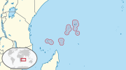
Southern Africa (redirect from Geography of Southern Africa)
Malawi, Mauritius, Mozambique, Namibia, South Africa, Zambia, and Zimbabwe. In cultural geography, the island country of Madagascar is often not included...
37 KB (3,947 words) - 06:40, 10 June 2024
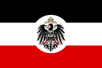
German South West Africa (redirect from German Namibia)
colonial-era Namibia genocide". Deutsche Welle. 28 May 2021. Retrieved 29 May 2021. Jaeger, Fritz; Leo Waibel (1920–1921). "Contributions to the Geography of South...
30 KB (3,177 words) - 19:37, 23 April 2024

provided as an overview of and topical guide to geography: Geography – study of Earth and its people. an academic discipline – a body of knowledge given to...
86 KB (7,718 words) - 12:44, 26 June 2024

German Namibians (German: Deutschnamibier) are a community of people descended from ethnic German colonists who settled in present-day Namibia. In 1883...
13 KB (1,570 words) - 21:07, 29 June 2024

Travel. 2012. Retrieved July 24, 2017. "Madagascar-GEOGRAPHY". countrystudies.us. U. S. Library of Congress. Retrieved 15 May 2021. Murray, N.J.; Phinn...
30 KB (2,866 words) - 18:14, 7 June 2024

Brandberg Mountain (redirect from Königstein, Namibia)
The Brandberg (Damara: Dâures; Otjiherero: Omukuruvaro) is Namibia's highest mountain. Brandberg Mountain is located in former Damaraland, now Erongo...
13 KB (1,331 words) - 04:39, 11 June 2024

List of cities and towns in Namibia Geography of Namibia Regions of Namibia Hartman, Adam (27 Aug 2010). "Town regrading a 'sad move'". The Namibian. Archived...
24 KB (1,330 words) - 20:19, 23 January 2024
Zambia Kowie River - South Africa Kuiseb - Namibia Kunene - Angola (as Cunene), Namibia Kwando - Namibia, also known as Linyanti and Chobe in places...
6 KB (561 words) - 17:35, 19 March 2024
Piracy Problem." (2012). "Geography of Seychelles - Archive - Seychelles Nation". www.nation.sc. Retrieved 2020-05-26. "Geography of Seychelles | Mauritius...
32 KB (2,004 words) - 20:34, 12 June 2024

Namibia is a multilingual country in which German is recognised as a national language. While English has been the sole official language of the country...
14 KB (1,419 words) - 22:56, 10 June 2024
biggest town in Namibia and the main port of the country. The town is served by the Walvis Bay International Airport. Geographically, the town is uniquely...
13 KB (1,383 words) - 17:06, 12 June 2024

Kalahari acacia–baikiaea woodlands (category Geography of Namibia)
Botswana, northern Namibia, South Africa and Zimbabwe. These woodlands cover the center of southern Africa, from northern Namibia diagonally through to...
5 KB (397 words) - 12:18, 11 April 2022

(Afrikaans: Conceptionbaai, German: Empfängnisbucht) is a bay on the coast of Namibia, Africa. The bay is exposed, thus not providing a useful anchorage. Conception...
3 KB (194 words) - 08:00, 22 December 2023