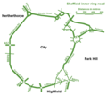
Hawaiʻi Belt Road is a modern name for the Māmalahoa Highway and consists of Hawaiʻi state Routes 11, 19, and 190 that encircle the Island of Hawaiʻi...
30 KB (2,583 words) - 17:11, 25 July 2024
longest complete belt road, or a beltway that is only two lanes, in the United States is Hawaii Belt Road, a 260-mile (420 km) belt in Hawaii that forms a...
43 KB (4,503 words) - 17:36, 2 August 2024

Hana Highway (redirect from Hawaii State Highway 36)
Duensing, Dawn (2007). "The Hana Belt Road: Paving the Way for Tourism" (PDF). Hawaiian Journal of History. 41. Hawaiian Historical Society. Retrieved January...
15 KB (1,188 words) - 16:01, 25 July 2024

Part V. Hawaii Belt Road, Hawaii Island: Pre-contact to 1960s" (PDF). Hawaii State Historic Bridge Inventory & Evaluation (Report). State of Hawaii, Department...
22 KB (2,182 words) - 20:23, 14 April 2024

as Saddle Road, traverses the width of the Island of Hawaiʻi, from downtown Hilo to its junction with Hawaii Route 190 near Waimea. The road was once considered...
19 KB (2,218 words) - 19:43, 9 July 2024

development consisted of 10,697 1-acre (4,000 m2) lots north of the Hawaii Belt Road in the western part of the District of Kaʻū. The terrain varies from...
15 KB (936 words) - 16:19, 5 June 2024

area is served by two major highways: the upper and lower routes of Hawaii Belt Road. The upper section is known as Mamalahoa Highway/Route 190, and the...
10 KB (672 words) - 02:25, 15 February 2024

(13 km) to the north. The junction of Hawaii Route 11 (the Hawaii Belt Road) and Hawaii Route 130 (Keaau-Pahoa Road) is in the northern part of the community...
10 KB (658 words) - 05:11, 13 December 2023

Park Keahole Point in the North Kona District. The entrance is on the Hawaii Belt Road at coordinates 19°42′58″N 156°02′01″W / 19.71611°N 156.03361°W /...
5 KB (492 words) - 11:29, 22 June 2024

warning. This tsunami also caused the end of the Hawaii Consolidated Railway, and instead the Hawaii Belt Road was built north of Hilo using some of the old...
37 KB (2,944 words) - 18:20, 14 August 2024

by Kealakekua and to the south by Honaunau-Napoopoo. Hawaii Route 11, part of the Hawaii Belt Road, passes through the community, leading north 12 miles...
14 KB (1,005 words) - 02:16, 8 May 2024

ʻAkaka Falls State Park (redirect from ‘Akaka Falls Road)
park on Hawaiʻi Island, in the U.S. state of Hawaii. The park is about 11 miles (18 km) north of Hilo, west of Honomū off the Hawaii Belt Road (Route 19)...
4 KB (399 words) - 07:54, 9 April 2024

Kohala include Akoni Pule Highway (Hawaii state route 270) which provides access to Pololū Valley. The Hawaii Belt Road which connects in the southern end...
10 KB (779 words) - 02:42, 15 February 2024

park is from the Hawaii Belt Road. The Chain of Craters Road leads to the coast, passing several craters from historic eruptions. The road had continued...
33 KB (3,007 words) - 18:49, 16 July 2024

Rainbow (Waiānuenue) Falls is a waterfall located in Hilo, Hawaii. It is 80 ft (24 m) tall and almost 100 ft (30 m) in diameter. The falls are part of...
2 KB (253 words) - 01:30, 3 August 2023

The Hawaii Department of Transportation (HDOT) maintains the smallest state-maintained system of state highways in the country. It consists of Interstates...
130 KB (682 words) - 17:33, 14 August 2024

Kaua'i Belt Road-North Shore section, is a ten-mile (16 km) scenic road on the northern shore of the island of Kauaʻi in Hawaii. The entire belt road is signed...
8 KB (661 words) - 16:13, 16 February 2024
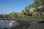
percentage of people of Italian descent in Hawaii. One Nīnole is in the Kaʻū District south of Route 11 (Hawaii Belt Road) adjacent to the south of Punaluʻu Beach...
6 KB (365 words) - 15:56, 27 July 2023

southern terminus), near the Hawaii Preparatory Academy campus. Route 19 at this point is known as Hawaii Belt Road, or Kawaihae Road. The northern terminus...
3 KB (207 words) - 16:14, 16 February 2024

offshore from Lili'uokalani Park and Gardens, in Hilo, off the island of Hawaii. It is a small park, and is connected to the main island via a footbridge...
3 KB (307 words) - 16:54, 24 November 2023
Hilo, Hawaii is home to a number of educational institutions, including 2 post-secondary institutions, the University of Hawaii at Hilo and Hawaii Community...
2 KB (156 words) - 11:42, 7 April 2022
Society civic society Queen Kaʻahuman Highway, part of the Hawaii Belt Road Kaʻahumanu Avenue, Hawaii Route 32 on Maui Kuhina Nui office held by above rulers...
785 bytes (121 words) - 04:08, 30 June 2010

Ka Lae (redirect from South Point, Hawaii)
Lae is accessible via South Point Road, a 12-mile paved narrow road leading from State Route 11 (Hawaii Belt Road), the turn off being about 7 miles...
16 KB (1,639 words) - 21:53, 7 August 2023

University of Hawaiʻi at Hilo (UH Hilo) is a public university in Hilo, Hawaiʻi. It is one of ten campuses of the University of Hawaiʻi System. It was...
14 KB (1,325 words) - 20:22, 9 August 2024
Punaluʻu Beach (category Beaches of Hawaii (island))
136°N 155.504°W / 19.136; -155.504. Access is from the Hawaii Belt Road: take Ninole loop road or the entrance to the Sea Mountain Resort. Camping is...
16 KB (2,076 words) - 23:27, 15 June 2024

Kolekole Beach Park (category Protected areas of Hawaii (island))
19.81167°N 155.36444°W / 19.81167; -155.36444) to sea level. The Hawaii Belt Road (state route 19) passes over the park on a high bridge. The park is...
4 KB (575 words) - 07:50, 19 April 2024

Kamehameha III (redirect from Kamehameha III of Hawaii)
Mausoleum of Hawaii known as Mauna ʻAla. The access to his birthplace at Keauhou Bay is via Kamehameha III Road from the north from Hawaii Belt Road, at 19°34′7″N...
33 KB (3,326 words) - 02:59, 11 May 2024

Hawaiʻi Community College is a public community college with two campuses on the Island of Hawaii. It is part of the University of Hawaiʻi System and is...
3 KB (173 words) - 15:20, 25 June 2024
ʻUpolu Point (category Headlands of Hawaii)
is Hawi, Hawaii about 2 miles (3 km) inland. The main road is Akoni Pule Highway t(Hawaii state route 270) which starts at the Hawaii Belt Road in Kawaihae...
2 KB (283 words) - 19:28, 26 January 2024

Kuakini (category Governors of Hawaii (island))
the Daughters of Hawaiʻi, including some of his artifacts. A highway is named "Kuakini Highway", which runs from the Hawaii Belt Road through the town...
11 KB (964 words) - 13:33, 3 June 2024