
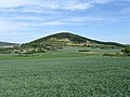
The Hohe Acht (German: [ˌhoːə ˈʔaxt]) is the highest mountain (746.9 m above sea level (NHN)) in the Eifel mountains of Germany. It is located on the...
5 KB (436 words) - 20:17, 20 August 2024
and graphic artist Acht, Rhineland-Palatinate, Germany Acht, village within the municipality of Eindhoven, Netherlands Hohe Acht, a mountain peak in...
790 bytes (130 words) - 00:03, 4 February 2021

district of Ahrweiler. South of the Ahr is the High Eifel (Hohe Eifel), with the Hohe Acht (747 m) being the highest mountain of the Eifel. In the west...
83 KB (8,205 words) - 08:08, 20 August 2024
of Ardennes and Eifel, framed by the rivers Semois, Meuse, Moselle and Rhine. The highest elevation is the Hohe Acht at 746.9 m above sea level. NHN...
21 KB (2,094 words) - 05:12, 1 September 2024

section, with gradients in excess of 16%, leading to a right-hander called Hohe Acht, which is some 300 m higher in altitude than Breidscheid. A favourite...
168 KB (12,132 words) - 20:27, 1 September 2024
High Eifel (redirect from Hohe Eifel)
precipitation lies between 800 mm and 1000 mm. Hohe Acht (747 m) Nürburg Castle (678 m) Hochkelberg (675 m) Dreiser Höhe (611 m) Maifeld Pellenz Vordereifel Vulkan...
1 KB (144 words) - 14:18, 27 July 2023

Eifel. From a natural region perspective it lies in the south of the Hohe Acht Upland (which belongs to the natural regional major unit of the Eastern...
7 KB (826 words) - 04:40, 20 October 2023

municipality of Vordereifel within sight of the Eifel's highest peak, the Hohe Acht. Walkers and naturalists are drawn to its juniper heaths. It is accessible...
2 KB (154 words) - 12:19, 15 April 2021
461525 (Goldberg volcano) - Hohe Acht 747 2447 50°23′09″N 7°00′40″E / 50.3858°N 7.01111°E / 50.3858; 7.01111 (Hohe Acht) - Mons Nore 678 2224 50°20′49″N...
4 KB (91 words) - 02:40, 13 May 2024

Egge Hills Preußischer Velmerstot 468 1,535 North Rhine-Westphalia Eifel Hohe Acht 747 2,451 Rhineland-Palatinate Elbe Sandstone Mountains Großer Zschirnstein...
24 KB (142 words) - 11:46, 24 June 2024
Schafbach which is part of the Olef catchment as well as other summits such as the Hohe Acht. Map services of the Federal Agency for Nature Conservation...
2 KB (133 words) - 12:20, 28 June 2017

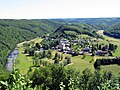
A view at the Ardennes near Stavelot A view at the Eifel near Nürburg Hohe Acht, the highest summit of the Eifel Ourthe river near Rendeux Upper Sûre...
3 KB (222 words) - 13:49, 16 January 2023

good view of the Siebengebirge as well as the High Eifel, including the Hohe Acht, as well as good views to the west. Prominence and isolation by TK 25;...
2 KB (160 words) - 09:09, 15 September 2023
Beimberg, Herne, North Rhine-Westphalia Kaiser Wilhelm Tower (Hohe Acht), on the Hohe Acht in the Eifel, near Adenau, Ahrweiler, Rhineland-Palatinate Kaiser...
2 KB (343 words) - 14:57, 14 June 2021

(Hoher Schneeberg) ± 30″ Eifel Hohe Acht 746 50°23′30″N 07°00′30″E / 50.39167°N 7.00833°E / 50.39167; 7.00833 (Hohe Acht) ± 30″ Hoher Meißner Kasseler...
11 KB (509 words) - 15:40, 3 August 2024

Ruppelstein (755 m), Birkenfeld district, Schwarzwälder Hochwald, Hunsrück Hohe Acht (747 m), Ahrweiler district, High Eifel, Eifel Idarkopf (746 m), Birkenfeld...
19 KB (1,330 words) - 18:35, 14 March 2022
Mayenfeldgau on the line from Rheineck up the Vinxtbach stream to the Hohe Acht; in the west it bordered on the Eifelgau and Zülpichgau along the Adenaubach...
3 KB (324 words) - 18:09, 2 March 2023

is, at 698.8 m, the highest of the west Eifel volcanoes and, after the Hohe Acht, the second highest mountain in the Eifel overall. Its summit consists...
3 KB (235 words) - 23:45, 21 October 2022

Feldberg (~880) Langenberg (843.2) Erbeskopf (816.32) Taufstein (773.0) Hohe Acht (746.9) Botrange (694.24) Donnersberg (686.5) Wüstegarten (675.3) Nordhelle...
29 KB (2,178 words) - 18:33, 20 March 2022

which is located between Kirchsahr and Krälingen, there are views of the Hohe Acht, the Michelsberg, the Nürburg and even the Scharteberg and Döhmberg. Near...
3 KB (200 words) - 12:30, 28 June 2017

Kalvarienberg there is an extensive view over the Eifel region. For example, the Hohe Acht and the Nürburg, 23 kilometres away, may be seen. In addition, the surrounding...
5 KB (418 words) - 18:58, 11 March 2021

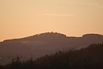
south The East Top from the south The Hochsimmer (right), seen from the Hohe Acht View from Hochstein List of volcanoes in Germany Map service of the Landscape...
4 KB (346 words) - 14:26, 17 August 2024

Niederzissen Station 14 Tuff Rock Centre (Tuffsteinzentrum), Weibern Station 15 Hohe Acht (746,9 m), highest mountain in the Eifel Station 16 Stone quarry at Raustert...
5 KB (167 words) - 15:12, 1 June 2023
Elevation Height (m) Eifel region(s) District/ Province Remarks Image Hohe Acht 746.9 High Eifel Ahrweiler, Mayen-Koblenz Highest elevation in the Eifel...
23 KB (126 words) - 15:47, 20 March 2022

8 m above sea level (NHN), is the second highest peak in the Eifel after the Hohe Acht (746.9 m). List of nature parks in Germany Der Naturpark Vulkaneifel und...
3 KB (291 words) - 08:53, 30 March 2024
Man"), which is also the third highest point of the Eifel range after the Hohe Acht and the Erresberg (Ernstberg). There is a winter sports area on the Schwarze...
2 KB (292 words) - 19:33, 1 January 2022
27), major unit of the Eastern High Eifel (271), the sub-unit of the Hohe-Acht/Nitz-Nette Upland (271.2) and the natural region of the Nitz-Nette Forest...
5 KB (535 words) - 21:58, 11 June 2023
view that reaches to the Siebengebirge hills, the basalt kuppen of the Hohe Acht, the Hochthürmerberg and Aremberg hills as well as the Schneifel and Rur...
8 KB (830 words) - 22:32, 13 August 2024
Eifel (27), the major unit, Eastern High Eifel (271), and minor unit, Hohe Acht/Nitz-Nette Upland (271.2). The majority of the Hochstein Hochstein Nature...
4 KB (439 words) - 08:50, 14 April 2024