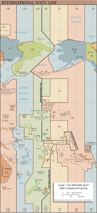
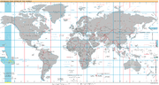
The International Date Line (IDL) is the line between the South and North Poles that is the boundary between one calendar day and the next. It passes...
46 KB (5,342 words) - 19:12, 5 July 2024
The international date line in Judaism is used to demarcate the change of one calendar day to the next in the Jewish calendar. The Jewish calendar defines...
20 KB (2,601 words) - 19:58, 21 March 2024

shown on some maps, but its existence is doubted. The International Date Line passes through the Line Islands. The ones that are parts of Kiribati are in...
19 KB (1,513 words) - 20:36, 24 June 2024

SS Warrimoo (section International Date Line claim)
the subject of a claim that she crossed the intersection of the International Date Line and the Equator precisely at the turn of the year from 1899 to...
10 KB (766 words) - 17:07, 8 June 2024

longitude line and creates a large fold in the International Date Line around the Pacific nation of Kiribati. Principal settlement: Kiritimati Kiribati Line Islands...
4 KB (550 words) - 00:44, 30 June 2024
The legal and cultural expectations for date and time representation vary between countries, and it is important to be aware of the forms of all-numeric...
106 KB (4,019 words) - 19:05, 8 July 2024

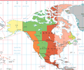
last to enter a New Year, and is sometimes referred to as the International Date Line West (IDLW) time zone. United States United States Minor Outlying...
3 KB (347 words) - 16:09, 14 May 2024
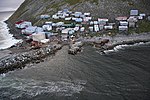
Island and is a part of Russia. In addition to an international boundary, the International Date Line also separates the two islands. As of 2021, the town...
11 KB (1,131 words) - 08:58, 9 June 2024
ships which cross the International Date Line. A sailor enters the dragon's empire when they cross the International Date Line by sailing west, where...
2 KB (235 words) - 17:49, 18 May 2024

208 miles (181 nmi; 335 km) away (and on the other side of the International Date Line). Attu is nearly 1,100 miles (960 nmi; 1,800 km) from the Alaskan...
39 KB (3,893 words) - 05:37, 18 May 2024
Philippine Standard Time (section Date and time format)
that the International Date Line moved from going west of the Philippines to go on the east side of the country, thereby moving it from the date of the...
16 KB (1,372 words) - 11:47, 10 July 2024
Although Kiribati spans both the equator and the 180th meridian, the International Date Line goes around Kiribati and swings far to the east, almost reaching...
7 KB (667 words) - 23:14, 10 June 2024

Diomede Islands (category International archipelagoes)
part of the Diomede Islands. Because they are separated by the International Date Line, Big Diomede is almost a day ahead of Little Diomede, but not completely;...
11 KB (1,131 words) - 22:08, 29 February 2024

meridian is its use as the basis for the International Date Line, which snakes around national borders to maintain date consistency within the territories of...
7 KB (391 words) - 09:51, 28 March 2024

Old Style and New Style dates (redirect from Old Style date)
was repeated on successive days, because at the same time the International Date Line was moved, from following Alaska's eastern border with Yukon to...
31 KB (3,786 words) - 03:09, 10 June 2024
Islands, in the IDLW time zone (the Western Hemisphere side of the International Date Line). Therefore, the day ends AoE when it ends on Howland Island. The...
3 KB (303 words) - 13:33, 6 May 2024

cyclones in the Pacific Ocean, north of the equator and east of the International Date Line. A Category 5 Pacific hurricane is therefore a tropical cyclone...
32 KB (2,675 words) - 19:06, 6 June 2024

on Tonga, which lies east of the 180° meridian but west of the International Date Line. He was the brother of John Harvey Kellogg. Merritt Gardner Kellogg...
12 KB (1,377 words) - 05:58, 21 March 2023
maritime personnel who crossed the junction of the Equator and the International Date Line at the Sacred Hour of the Vernal Equinox. The Order of the Red...
30 KB (3,409 words) - 04:40, 18 June 2024
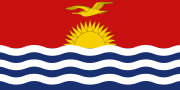
the Northern, Southern, Western, and Eastern hemispheres. The International Date Line goes around Kiribati and swings far to the east, almost reaching...
135 KB (13,838 words) - 16:10, 5 July 2024

Hawaii, monitoring the North Central Pacific basin (between the International Date Line and the 140°W meridian); and the military Joint Typhoon Warning...
8 KB (731 words) - 09:32, 30 June 2024

arbitrary division, such as Antarctic Circle, Arctic Circle, Border, International Date Line, Latitude, including the Equator, Longitude, the Prime Meridian...
2 KB (195 words) - 12:48, 9 July 2024
the same time as the Samoa Time Zone until it moved across the International Date Line at the end of 29 December 2011; Samoa was then 24 hours ahead of...
3 KB (235 words) - 03:35, 19 June 2024
Line Islands – including Kiritimati (Christmas Island) advanced 24 hours (to UTC+14:00) to the eastern hemisphere side of the International Date Line...
2 KB (187 words) - 23:32, 22 January 2024

the International Date Line by skipping December 30, 2011. Samoa – Time in Samoa advanced 24 hours to the eastern hemisphere side of the International Date...
3 KB (318 words) - 21:02, 19 February 2024

1994 (section Date unknown)
days, omitting December 31. This was due to an adjustment of the International Date Line by the Kiribati government to bring all of its territories into...
92 KB (8,013 words) - 05:37, 9 July 2024

strength of 130 mph (215 km/h), and shortly thereafter it crossed the International Date Line at approximately 22° N and came under the surveillance of the Guam...
20 KB (2,264 words) - 01:15, 3 July 2024
last sunset (at equinox) in U.S. territory. West of it passes the International Date Line, after which come Russian territorial islands. List of countries...
987 bytes (78 words) - 08:51, 26 April 2020

is both 180°W and 180°E. This is not to be conflated with the International Date Line, which diverges from it in several places for political and convenience...
22 KB (2,499 words) - 22:33, 8 July 2024

Ioke attained Category 5 status on August 25 before crossing the International Date Line. As it continued westward, its intensity fluctuated, and on August...
36 KB (3,527 words) - 16:34, 8 May 2024