
Jamanota is a hill situated within Aruba's Arikok National Park, reaching a height of 188 metres (617 ft) and holding the distinction of being the highest...
24 KB (2,565 words) - 21:09, 7 May 2024

Santa Cruz, Aruba (redirect from Jamanota, Aruba)
neighborhoods, including, but not limited to, Boton, Bringamosa, Cas Ariba, Jamanota, Jan Flemming, Macuarima, San Fuego, Shete, Siribana, Urataka, Warawara...
4 KB (283 words) - 08:55, 8 August 2023
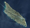
rolling terrain with some low hills. The highest point on the island is Jamanota, reaching almost 188 metres (617 ft) in elevation. There are three distinct...
45 KB (4,659 words) - 01:18, 29 May 2024

Lava Formation (ALF). This region is marked by rolling hills, including Jamanota, and is home to Arikok National Park, and lastly the limestone terraces...
127 KB (13,007 words) - 14:12, 15 August 2024
Philippines * Unguja Koani Mountain 195 m 640 ft Tanzania * Aruba Mount Jamanota 188 m 617 ft Aruba (Netherlands) * Iwo Jima Mount Suribachi 169 m 554 ft...
78 KB (253 words) - 13:16, 26 July 2024
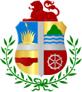
and second quarters of the coat of arms, namely a sun and the peak of Jamanota, were changed to the Aloe vera and Hooiberg, respectively. The official...
8 KB (587 words) - 12:48, 17 April 2024

4090 m 13,419 ft Aras River 375 m 1,230 ft 3715 m 12,188 ft Aruba Mount Jamanota 188 m 617 ft Caribbean Sea sea level 188 m 617 ft Ashmore and Cartier Islands...
49 KB (2,072 words) - 00:58, 1 August 2024

geological formation on the island; in fact, that is a common misconception. Jamanota, which stands at 188 m (617 ft), holds that title. Nevertheless, Hooiberg...
26 KB (2,508 words) - 06:30, 20 August 2024

until 1980 that a plan was put forth for the development of the Arikok-Jamanota area as a national park. Only a portion of this plan was realized, leading...
25 KB (1,845 words) - 18:12, 15 June 2024
Leeward Antilles Time zone: Eastern Caribbean Time (UTC-04) High: Mount Jamanota 188 m (617 ft) Low: Caribbean Sea 0 m Land boundaries: none Coastline:...
9 KB (741 words) - 22:24, 25 June 2024
areas in eastern Aruba, from Cashiunti, Huliba, Kiwarcu to Coashiati or Jamanota, and the north coast between Andicuri and Oranjestad, abound in Caquetío...
12 KB (1,238 words) - 09:50, 26 May 2024