state of Arizona's State Routes are usually abbreviated as SR. The Arizona State Highway system was introduced on September 9, 1927, by the State Highway...
50 KB (1,442 words) - 13:32, 15 August 2023
a list and summary of the former state routes in Arizona, including mileage tables and maps. Between the establishment of Arizona's numbered state highway...
93 KB (8,974 words) - 00:23, 10 July 2024

State Route 89 (SR 89) is a 104.53-mile (168.22 km) state highway in the U.S. state of Arizona. It is part of the former route of U.S. Route 89 (US 89)...
5 KB (254 words) - 04:36, 19 March 2024

Arizona State Route 202 (SR 202) or Loop 202 (202L) is a semi-beltway circling the eastern and southern areas of the Phoenix metropolitan area in central...
45 KB (3,333 words) - 20:50, 24 May 2024
Below is a list and summary of the unconstructed state highways in the U.S. state of Arizona. Some are currently proposed while the others have since...
17 KB (1,572 words) - 17:24, 3 May 2024

State Route 89A (SR 89A) is an 83.85-mile (134.94 km) state highway that runs from Prescott north to Flagstaff in the U.S. state of Arizona. The highway...
27 KB (2,115 words) - 20:08, 19 December 2023

State Route 95, also known as SR 95, is a north–south state highway along the western edge of Arizona that is split into two sections. The southern segment...
10 KB (574 words) - 10:33, 29 March 2024

160 near Cortez, Colorado along the routes of State Route 14, U.S. Route 89, Arizona State Route 98, U.S. Route 160, the current US 163, the new road...
16 KB (1,629 words) - 10:18, 28 August 2023
Arizona (/ˌærɪˈzoʊnə/ ARR-ih-ZOH-nə; Navajo: Hoozdo Hahoodzo [hoː˥z̥to˩ ha˩hoː˩tso˩]; O'odham: Alĭ ṣonak [ˈaɭi̥ ˈʂɔnak]) is a landlocked state in the...
162 KB (13,722 words) - 22:38, 13 July 2024

State Route 66 (SR 66) is a surface road in the U.S. state of Arizona in Mohave and Coconino Counties. In 1914, the road was designated "National Old...
7 KB (550 words) - 18:00, 24 March 2024

State Route 92 (SR 92) is a state highway in the U.S. state of Arizona. Running roughly in an L-shaped pattern, SR 92 begins at SR 90 in Sierra Vista and...
7 KB (662 words) - 04:21, 4 January 2024

Larls, W.B. (1927). Official State Routes and State Highways of the State of Arizona (Map). Scale not given. Phoenix: Arizona Highway Department. Retrieved...
40 KB (2,441 words) - 21:49, 3 March 2024

Interstate 17 (redirect from Arizona State Route 79 (1950-1968))
the US state of Arizona. I-17's southern terminus lies in Phoenix, at I-10/US 60 and its northern terminus is in Flagstaff, at Milton Road north of I-40...
26 KB (1,443 words) - 03:24, 6 June 2024

Arizona State Route 101 (SR 101) or Loop 101 is a semi-beltway looping around the Phoenix Metropolitan Area in central Arizona, United States. It connects...
25 KB (1,732 words) - 02:40, 6 February 2024

State Route 79 (SR 79), also known as the Pinal Pioneer Parkway, is a 58.40 mi (93.99 km) long state highway in the U.S. state of Arizona. It serves as...
19 KB (1,926 words) - 21:22, 27 June 2023

State Route 88 is a long state highway in the U.S. state of Arizona. It runs from U.S. Route 60 (US 60) in Apache Junction through desert terrain to SR...
13 KB (1,127 words) - 16:08, 29 November 2023

U.S. Route 93 (US 93) is a United States Numbered Highway in the state of Arizona that begins in Wickenburg and heads north to the Nevada state line at...
27 KB (2,974 words) - 19:25, 5 April 2024

southeastern suburbs of Phoenix to planned ones in northwestern Pinal County. It is the lowest-numbered state route in Arizona. The first mile from Loop...
18 KB (1,667 words) - 06:35, 7 June 2024

State Route 64 (SR 64) is a 108.31-mile-long (174.31 km) state highway in the northern part of the US state of Arizona. It travels from its western terminus...
8 KB (669 words) - 01:59, 9 July 2023

Interstate 19 (redirect from Arizona State Route 19 Business)
is a north–south Interstate Highway located entirely within the US state of Arizona. I-19 travels from Nogales, roughly 90 meters (300 ft) from the Mexican...
29 KB (2,697 words) - 23:45, 11 June 2024

Arizona State Route 51 (SR 51), also known as the Piestewa Freeway, is a numbered state highway in Phoenix, Arizona. It connects Interstate 10 and Loop...
15 KB (1,203 words) - 14:35, 3 July 2024

State Route 72 (SR 72) is a 36.74-mile-long (59.13 km) state highway in the U.S. state of Arizona. It runs from SR 95 near Parker southeast to U.S. Route...
9 KB (895 words) - 00:39, 10 November 2021

State Route 80 (SR 80) is a 120.20-mile (193.44-kilometre) long, roughly arc-shaped highway lying in southeastern Arizona. Starting in downtown Benson...
15 KB (1,581 words) - 22:09, 25 June 2023

Interstate 8 (redirect from Arizona State Route 8)
U.S. Route 80 (US 80) across California and part of Arizona, and Arizona State Route 84 (SR 84) between Gila Bend and Casa Grande. The US 80 freeway through...
111 KB (11,974 words) - 18:13, 28 May 2024

State Route 90 (SR 90) is a highway in Cochise County, Arizona that runs from the I-10 junction at Benson to a junction with State Route 80 between Bisbee...
8 KB (711 words) - 01:31, 8 September 2023

all its related routes in Arizona were renumbered to extensions and special routes of US 191. US 191 Bus. begins at the Douglas port of entry. Heading...
47 KB (4,570 words) - 17:51, 15 April 2024

Superstition Mountains (category Mountain ranges of Maricopa County, Arizona)
residents of the Phoenix, Arizona, area. They are roughly bounded by U.S. Route 60 on the south, Arizona State Route 88 on the northwest, and Arizona State Route...
13 KB (811 words) - 22:14, 6 May 2024
U.S. state of Arizona. It connects State Route 89A in Cottonwood to U.S. Route 180 and U.S. Route 191 in Eagar. The highway begins in Yavapai County...
8 KB (455 words) - 00:55, 19 March 2024

State Route 69 (SR 69) is a highway that serves as the main road to Prescott, Arizona, from Interstate 17. The highway mainly consists of four-lanes (two...
7 KB (586 words) - 02:39, 8 November 2023
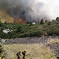
Yarnell Hill Fire (redirect from 2013 Arizona fire)
firefighter disaster in history, the deadliest wildfire ever in the state of Arizona, and (at least until 2014) was "the most-publicized event in wildland firefighting...
32 KB (3,426 words) - 23:01, 13 July 2024