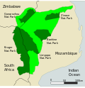
The Makuleke Contractual Park or Pafuri Triangle constitutes the northernmost section of the Kruger National Park, South Africa, and comprises approximately...
21 KB (2,380 words) - 07:46, 15 July 2024
Makulele may refer to: Makuleke, Makulele Area, Makuleke Region, or Pafuri Triangle of the Kruger National Park Makulele (people), Makuleke, people living in...
337 bytes (76 words) - 21:04, 11 January 2016

inhibit the movement of poachers. The Makuleke area in the northern part of the park was forcibly taken from the Makuleke people by the government in 1969...
68 KB (5,528 words) - 17:41, 17 November 2024
between Kruger and Gonarezhou, the Sengwe communal land in Zimbabwe and the Makuleke region in South Africa. The memorandum of understanding for the creation...
4 KB (440 words) - 19:44, 18 November 2024

The Makuleke are a Tsonga tribe living in the Pafuri Triangle of South Africa at the confluence of the Luvuvhu river and Limpopo river in what is now the...
5 KB (722 words) - 06:03, 13 December 2023
Makuleke Dam is an earth-fill type dam located on the Mphongolo River, a tributary of the Shingwedzi River. It is located near Malamulele, at Makuleke...
2 KB (85 words) - 09:57, 22 July 2024
area in the Langebaan lagoon in the Western Cape province of South Africa Makuleke Wetlands Middelpunt Nature Reserve Natal Drakensberg Park – Part of a world...
47 KB (7,028 words) - 09:35, 9 September 2024
between Kruger and Gonarezhou, the Sengwe communal land in Zimbabwe and the Makuleke region in South Africa. This park is home to mammalian species including...
4 KB (429 words) - 22:44, 1 November 2024
Kosi Bay 10,982 27,140 Lake Sibaya 7,750 19,200 Langebaan 6,000 15,000 Makuleke Wetlands 7,757 19,170 Middelpunt Nature Reserve 510.3 1,261 Natal Drakensberg...
244 KB (220 words) - 16:36, 14 November 2024
Tsonga), Changana (Xichangana, Shangaan, Shangana), Xiluleke (S53A, Mhinga, Makuleke), N’walungu (S53B, Shingwalungu), Hlave (S53C), Nkuna (S53D), Gwamba (S53E...
84 KB (244 words) - 18:01, 18 July 2021
018°04′E / 33.150°S 18.067°E / -33.150; 18.067 60.00 25/04/1988 [15] Makuleke Wetlands Kruger National Park 22°23′S 031°12′E / 22.383°S 31.200°E /...
8 KB (130 words) - 08:18, 22 November 2024
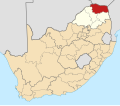
forms the boundary between the Kruger National Park to the South and the Makuleke Concession to the North. It was carved by the Luvuvhu River and is at some...
6 KB (459 words) - 07:45, 15 July 2024
Dam) Makuleke Dam Giyani Limpopo Mphongolo River 1990 13,000 0.750 22 22°52′3″S 30°54′18″E / 22.86750°S 30.90500°E / -22.86750; 30.90500 (Makuleke Dam)...
54 KB (855 words) - 14:00, 8 October 2024
Nature Reserve, the Nwanedi Nature Reserve, the Makgabeng Plateau, the Makuleke Wetlands, the Mapungubwe Cultural Landscape and the Soutpansberg. The main...
15 KB (821 words) - 14:40, 10 November 2024

the Soutpansberg, the northern part of the Kruger National Park, the Makuleke Wetlands and the Mapungubwe Cultural Landscape. The eastern and part of...
8 KB (703 words) - 09:43, 4 August 2024

rest camp; the Kanniedood Dam and the Sirheni Dam.[citation needed] The Makuleke Dam is in the Mphongolo River. After crossing into Mozambique, the river...
6 KB (357 words) - 08:03, 2 November 2024

Jones 3,371 3.17 Lulamani 61 0.11 Machele 1,192 1.03 Madonsi 3,220 3.05 Makuleke 4,502 3.31 Malamulele 13,070 9.57 Mapimele 467 0.40 Mavambe 4,133 5.28...
10 KB (607 words) - 22:57, 9 November 2024

Punda Maria Camp up to Thulamela. Great Zimbabwe Kingdom of Mapungubwe Makuleke tribe Shingwedzi Miller, Sidney Mears (2018). Thulamela: The Lost Gold...
5 KB (413 words) - 19:03, 25 February 2024
2011). "Tourism-Led Development in South Africa: a case study of the Makuleke partnership with Wilderness Safaris" (PDF). University of the Witwatersrand:...
8 KB (794 words) - 07:52, 27 August 2024
population of 11,299. These main areas are: Gijana (Magona), Madonsi, Makuleke, Mavambe, Mhinga, Mphambo, Mtititi, Mudavula, Mukhomi, Gumbani, Mulamula...
18 KB (1,488 words) - 19:15, 15 March 2024
in Southern Africa". publishing.cdlib.org. Steenkamp, C. (2000). "The Makuleke Land Claim" (PDF). IIED Evaluating Eden Programme. Archived from the original...
6 KB (131 words) - 01:32, 1 June 2022

museum in Letaba camp Real fan palm at the southern limit of its range Makuleke Thulamela Jenkins, Elwyn (2007). Falling Into Place: The Story of Modern...
22 KB (2,455 words) - 18:36, 25 September 2024

(SVk 1) Makatini Clay Thicket (SVl 21) Makhado Sweet Bushveld (SVcb 20) Makuleke Sandy Bushveld (SVl 1) Malelane Mountain Bushveld (SVl 11) Mamabolo Mountain...
28 KB (3,169 words) - 06:54, 8 May 2024