
The Qattara Depression Project or Qattara Project is a macro-engineering project concept in Egypt. Rivalling the Aswan High Dam in scope, the intention...
13 KB (1,542 words) - 13:41, 16 February 2025
The Qattara Depression (Arabic: منخفض القطارة, romanized: Munḫafaḍ al-Qaṭṭārah) is a depression in northwestern Egypt, specifically in the Matruh Governorate...
24 KB (2,912 words) - 12:55, 2 March 2025

Friedrich Bassler (section Qattara Depression Project)
energy project at the Qattara Depression further. He directed the "Board of Advisers" which was responsible for the planning and financing of the project. For...
10 KB (1,235 words) - 15:32, 12 May 2024
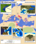
Atlantropa (redirect from Atlantropa Project)
Imperialism Megaproject Northern European Enclosure Dam Qattara Depression Project Lake Chad replenishment project Red Sea Dam Strait of Gibraltar crossing Three...
17 KB (1,701 words) - 16:30, 27 January 2025

Sahara Sea (section Other desert flooding projects)
idea to use nuclear explosives in civil engineering projects such as the Qattara Depression Project. It was also suggested that nuclear explosives might...
13 KB (1,398 words) - 03:45, 3 March 2025

Siwa Oasis (redirect from Siwa Depression)
[ˈwæːħet ˈsiːwæ]) is an urban oasis in Egypt. It is situated between the Qattara Depression and the Great Sand Sea in the Western Desert, 50 kilometres (31 mi)...
47 KB (4,841 words) - 18:38, 2 January 2025
the Qattara Depression in Egypt, an area that lies below sea level. The core problem of the entire project was the water supply to the depression. Calculations...
48 KB (5,169 words) - 01:52, 6 January 2025

as ludicrous. Atlantropa Bridge of the Horns Hydroelectricity Qattara Depression Project Water portal Power from closing the Red Sea: Economic and ecological...
4 KB (364 words) - 00:47, 23 December 2023
cartographer (c. 1470 – 1553) – Early cartographer of the Mediterranean Qattara Depression Project – Hydroelectric macro-engineering concept in Egypt Seto Inland...
180 KB (17,389 words) - 06:16, 3 March 2025
Macro-engineering (section Projects)
Megascale engineering Permaculture Permaforestry Sahara Forest Project Qattara Depression Project Red Sea dam Sand fence Seawater Greenhouse Sustainable agriculture...
4 KB (439 words) - 01:33, 25 October 2024
undeveloped in 2024 is the Qattara Depression. Several schemes have been proposed through the years to implement a Qattara Depression Project. None of which have...
29 KB (3,041 words) - 14:48, 3 March 2025

portal Wikimedia Commons has media related to Invasion of the Sea. Qattara Depression Project Chott Melrhir Canavan, Gerry (2018). The Cambridge History of...
10 KB (1,049 words) - 07:10, 20 February 2025
the Quattara Depression Project, is unusual in that salt water would be flowing from the Mediterranean Sea into the Qattara Depression, forming an artificial...
2 KB (236 words) - 13:13, 27 December 2024
unable to significantly expand its hydropower infrastructure. The Qattara Depression Project remains the only undeveloped large-scale hydropower site, with...
19 KB (1,934 words) - 16:18, 3 March 2025
Farafra, Dakhla, then Kharga in the south. East of Siwa lies the Qattara Depression, a low-lying area dotted with salt marsh and extending 310 km (190 mi)...
19 KB (2,385 words) - 01:30, 15 February 2025

late 1942. The defences stretch from the Mediterranean coast to the Qattara Depression. An estimated 16 million mines, planted by the Europeans during the...
3 KB (301 words) - 08:59, 10 February 2023

Endorheic basin (redirect from Endorheic depression)
of Africa. It covers an area of approximately 2.434 million km2. Qattara Depression, in Egypt. Chott Melrhir, in Algeria. Chott el Djerid, in Tunisia...
33 KB (3,766 words) - 18:38, 13 February 2025

First Battle of El Alamein (redirect from Battle of the Qattara box)
64 km (40 mi) to the south of El Alamein, the steep slopes of the Qattara Depression ruled out the possibility of Axis armour moving around the southern...
67 KB (8,403 words) - 10:37, 2 March 2025
Seawater greenhouse (redirect from Proposed Sahara forest project)
coasts; others are below sea level, such as the Dead Sea and the Qattara Depression, where hydro schemes have been proposed to exploit the hydraulic pressure...
18 KB (2,079 words) - 20:04, 30 January 2025

Tropical desert (section Depression)
the large enclosed basins in Africa, such as Farafra, Baharia, Dakhla, Qattara, Siwa and Kargha. Pans are widespread in southern and western Australia...
17 KB (2,130 words) - 13:33, 18 November 2024

an attack by the Axis would have to pass between the coast and the Qattara Depression about 40 mi (64 km) to the south and impassable for tanks. The Eighth...
35 KB (4,243 words) - 05:59, 4 March 2025

List of elevation extremes by country (category Pages using Sister project links with default search)
Valley is the lowest point of the United States and North America. The Qattara Depression is the lowest point in Egypt. Aydingkol is the lowest point of China...
50 KB (2,107 words) - 17:15, 27 February 2025

positions at El Alamein. This region is a natural choke point, where the Qattara Depression creates a relatively short line to defend that could not be outflanked...
274 KB (33,892 words) - 07:20, 4 March 2025
Aquifer, the Moghra Aquifer between the West of the Nile Delta and the Qattara Depression, and coastal aquifers on the North-Western coast. The Nile Aquifer...
51 KB (6,711 words) - 12:24, 4 March 2025

cover 54,000 square kilometres (21,000 sq mi) including: the Qattara and Siwa depressions in northern Egypt, the Tunisian salt lakes of central Tunisia...
103 KB (11,723 words) - 21:05, 18 February 2025
Sahara and is bordered by the Mediterranean Sea from the north and Qattara Depression and the Siwa Oasis from the south This vast area has a mild climate...
6 KB (638 words) - 11:33, 5 November 2024

Extreme points of Egypt High: Mount Catherine 2,629 m (8,625 ft) Low: Qattara Depression −133 m (−436 ft) Land boundaries: 2,665 km (1,656 mi) Sudan 1,273 km...
26 KB (1,812 words) - 08:59, 5 December 2024

(80 km) of Alexandria where the Qattara Depression was 40 mi (64 km) south of El Alamein on the coast. The depression was impassable and meant that any...
107 KB (14,564 words) - 10:37, 2 March 2025

supply much more efficient and the geographical bottleneck of the Qattara Depression, 40 mi (64 km) to the south, made an Axis outflanking move much more...
96 KB (12,524 words) - 23:51, 2 March 2025
Egypt (category Pages using Sister project links with hidden wikidata)
million hectares by 2030. Major initiatives include the New Delta and Toshka Project, designed to convert desert areas into farmland using advanced irrigation...
234 KB (22,302 words) - 15:28, 4 March 2025