
Sanborn maps are detailed maps of U.S. cities and towns in the 19th and 20th centuries. Originally published by The Sanborn Map Company (Sanborn), the...
23 KB (2,562 words) - 17:57, 1 May 2024
in Minnesota Sanborn (surname) Sanborn maps, maps of U.S. cities and towns in the 19th and 20th centuries, published by The Sanborn Map Company Daniel...
784 bytes (126 words) - 19:58, 6 December 2023
CityLab. Atlantic Media. Retrieved 13 October 2014. Sanborn Map Company Sanborn Fire Insurance Maps at University of Utah Digital Library, Marriott Library...
1 KB (124 words) - 15:39, 19 July 2021

Sanborn Fire Insurance Maps of Savannah are a series of historic publications by The Sanborn Map Company, documenting 19th and 20th century Savannah, Georgia...
4 KB (331 words) - 12:09, 17 February 2024

Archived January 26, 2012, at the Wayback Machine Historic maps of Kansas City in the Sanborn Maps of Missouri Collection Archived May 13, 2021, at the Wayback...
166 KB (15,352 words) - 16:23, 1 September 2024

Maps of Lima Ohio (Sanborn Maps). Ohio Web Library: Sanborn Map Company. 1950 [1911]. p. 29. Lima, Ohio (Sanborn Maps). Ohio Web Library: Sanborn Map...
10 KB (907 words) - 09:08, 13 June 2024

its post office in 1834. Carrollton's growth can be documented through Sanborn maps, several of which are available online. The Carroll County Court House...
13 KB (572 words) - 19:30, 12 January 2024
The first few decades of the town's growth can be documented through Sanborn maps, which recorded building ownership, materials, and use. In 1893, Missouri's...
21 KB (1,874 words) - 21:27, 17 March 2024

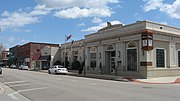
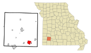
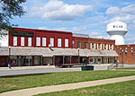
history of Jasper County. Growth in Carthage can be documented through Sanborn maps, many of which are available online. Numerous local buildings, in addition...
30 KB (3,236 words) - 09:44, 25 September 2024

School 318 S. Taylor Street Graham, MO 64455660-939-2135 Historic maps of Skidmore in the Sanborn Maps of Missouri Collection at the University of Missouri...
12 KB (1,316 words) - 20:56, 22 May 2024

contributing properties. The growth of the town can be documented through Sanborn maps, over 80 of which are available online. Other landmarks include the Fort...
55 KB (4,815 words) - 20:46, 23 September 2024

Evansville, Indiana. The fate of specific buildings may also be traced by Sanborn maps that were produced of the town during this period. This was the largest...
22 KB (1,876 words) - 00:07, 26 July 2024

has a travel guide for Marceline. Official website Historic maps of Marceline in the Sanborn Maps of Missouri Collection at the University of Missouri...
13 KB (1,022 words) - 05:08, 13 September 2024

United States Census Bureau. Retrieved July 8, 2012. Historic maps of Stoutsville in the Sanborn Maps of Missouri Collection at the University of Missouri...
10 KB (943 words) - 06:04, 17 September 2024

St. Louis Regional Chamber and Growth Association Historic maps of St. Louis in the Sanborn Maps of Missouri Collection at the University of Missouri...
169 KB (15,664 words) - 02:10, 27 September 2024
years after 1916, Pelham was the headquarters of the Sanborn Map Company, which produced Sanborn maps. The Pelham Picture House was added to the National...
22 KB (1,859 words) - 02:22, 20 August 2024

Victorian Downtown Los Angeles (section Map)
de los Negros (r) The Coronel Adobe was demolished in 1888 and 1896 Sanborn maps show that the Del Valle adobe had been removed, and Los Angeles Street...
18 KB (13,883 words) - 02:18, 6 July 2024

Corrosion Abstracts Design and Applied Arts Index (DAAI) Dialog Digital Sanborn Maps Early European Books Earthquake Engineering Abstracts Ebrary Ecology...
38 KB (3,316 words) - 04:44, 16 September 2024
Britannica article about Aurora, Missouri. City of Aurora Historic maps of Aurora in the Sanborn Maps of Missouri Collection at the University of Missouri...
16 KB (1,530 words) - 15:29, 18 September 2024

on June 10, 2017. Retrieved June 2, 2019. Historic maps of Elvins and Park Hill in the Sanborn Maps of Missouri Collection at the University of Missouri...
13 KB (1,472 words) - 20:56, 22 May 2024

Commons has media related to Lamar, Missouri. City of Lamar Historic maps of Lamar in the Sanborn Maps of Missouri Collection at the University of Missouri...
16 KB (1,164 words) - 03:17, 27 August 2024

America, by John William Leonard, 1914. Page 40. Historic maps of Humansville in the Sanborn Maps of Missouri Collection at the University of Missouri...
12 KB (1,117 words) - 22:53, 12 July 2024

City of Bonne Terre, Missouri The Space Museum Historic maps of Bonne Terre in the Sanborn Maps of Missouri Collection at the University of Missouri...
18 KB (1,982 words) - 21:07, 25 September 2024

SD Counties/Sanborn (accessed February 8, 2019) Sanborn County SD Google Maps (accessed February 8, 2019) ""Find an Altitude" Google Maps (accessed February...
12 KB (813 words) - 18:17, 27 April 2024

media related to Palmyra, Missouri. Official website Historic maps of Palmyra in the Sanborn Maps of Missouri Collection at the University of Missouri...
14 KB (1,249 words) - 13:24, 25 March 2024
National Baseball Hall of Fame. Retrieved June 5, 2020. Historic maps of Milan in the Sanborn Maps of Missouri Collection at the University of Missouri "Milan...
12 KB (1,038 words) - 12:53, 2 August 2024

Retrieved June 1, 2019. City of Festus City-data.com - Festus Historic maps of Festus in the Sanborn Maps of Missouri Collection at the University of Missouri...
20 KB (1,585 words) - 10:38, 14 September 2024
renamed 19th Street and is a major thoroughfare in Watervliet. The 1885 Sanborn map shows "Base Ball Park" south of Genesee and east of the railroad tracks...
1 KB (123 words) - 14:20, 31 August 2024

Avenues on Map 209, Insurance Maps of Seattle, Volume Two (1905), Sanborn Map Company, 11 Broadway, New York. Reproduced in the "Digital Sanborn Maps 1867–1970"...
15 KB (1,942 words) - 23:03, 27 February 2024

"Locations and Hours". Scenic Regional Library. Retrieved June 2, 2019. Sanborn Maps of Missouri Collection-Historic maps of Owensville Official website...
11 KB (1,005 words) - 01:45, 26 January 2024