
Schlichem is a river of Baden-Württemberg, Germany. It passes through Schömberg and flows, 33 km (21 mi) away, into the Neckar in Epfendorf. Its source...
5 KB (582 words) - 18:57, 29 April 2021
the southwest of the Swabian Jura, on the southern slope of the Upper Schlichem valley near Deilingen in the Tuttlingen district. It is part of the Großer...
889 bytes (58 words) - 13:50, 10 August 2019

the Schlichem hiking trail in Tieringen. Since 2015 an early train allows full-day excursions. Less experienced hikers can divide the Schlichem hiking...
4 KB (379 words) - 21:30, 23 August 2022
Epfendorf 1929 e.V. Founded 2 May 1929; 95 years ago (1929-05-02) Ground Schlichem Stadion Chairman Thorsten Sackmann League Kreisliga A (IX) 2019/20 14th...
4 KB (125 words) - 13:03, 22 May 2024

Rottweil-Bühlingen, 38.1 km) Prim (right tributary at Rottweil, 21.1 km) Schlichem (right tributary at Epfendorf, 34.4 km) Glatt (left tributary at Horb-Neckarhausen...
82 KB (9,579 words) - 04:27, 17 September 2024

foothills of the Swabian Jura, specifically towards the center of the Schlichem valley [de]. The valley marks the lowest elevation above sea level in...
4 KB (400 words) - 19:34, 16 February 2023

in the municipal area is the Schlichem, whose deeply-cut valley forms part of the northern municipal border. The Schlichem is also the location of the...
6 KB (559 words) - 12:55, 23 October 2023

northwest of its upper course, on the other side of Tieringen, runs the Schlichem, which flows northwest by way of the Neckar to the Rhine. The Obere Bära...
2 KB (148 words) - 19:30, 12 September 2020

located primarily in the High Swabian Jura [de], in the valley of the Schlichem, which flows through Ratshausen itself. Elevation above sea level in the...
5 KB (477 words) - 14:04, 25 July 2024
foothills of the Swabian Jura, on the albtrauf near the Ortenberg above the Schlichem. Elevation above sea level in the municipal area ranges from a high of...
4 KB (378 words) - 11:34, 13 June 2024

the Plettenberg. The primary watercourses in the municipal area are the Schlichem, which forms its southern border, and the Katzenbach, which flows into...
4 KB (358 words) - 02:46, 25 July 2024

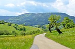
many sights. Epfendorf has an extensive network of hiking trails. The Schlichem hiking trail ends in Epfendorf. Less experienced hikers can walk in summer...
4 KB (402 words) - 20:24, 31 January 2024

the Schafberg to a low of 697 meters (2,287 ft) NN in the valley of the Schlichem. A portion of the Federally-protected Schafberg-Lochenstein [de] nature...
3 KB (355 words) - 23:42, 31 December 2021

is physically located on the Little Heuberg [de], a plateau above the Schlichem where oil shale can be found in the upper Liassic layers. The village...
4 KB (401 words) - 07:36, 6 February 2024

physically located on the western edge of the Swabian Jura, in the Upper Schlichem valley [de]. The town of Zimmern unter der Burg itself lies on the confluence...
4 KB (422 words) - 12:21, 10 July 2024
the Bühler Schießbach, tributary of the Nagold Schiltach Schleifseebach Schlichem Schlücht Schmerach Schmerbach Schmiddis Schmiebach Schmiech Schmiecha...
14 KB (1,032 words) - 03:50, 18 April 2024