
The Shimōsa Plateau (下総台地, Shimōsa-daichi) is a plateau on the Kantō Plain in central Honshu, Japan. The plateau covers most of northern Chiba Prefecture...
19 KB (1,745 words) - 08:45, 7 May 2024
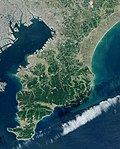
339 ft). From south to north the Bōsō Hill Range gives way to the Shimōsa Plateau, which covers much of the area of northern Chiba Prefecture, and ends...
6 KB (434 words) - 17:15, 27 November 2022

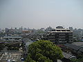
downtown Tokyo. The central area forms a flat diluvial upland of the Shimōsa Plateau. The city sits at an elevation of 20 to 30 meters above sea level,...
20 KB (1,308 words) - 09:05, 5 November 2023

the Japanese emperor oak or daimyo oak. Kashiwa is located on the Shimōsa Plateau in the far northwestern corner of Chiba Prefecture, about 30 kilometers...
16 KB (1,144 words) - 11:41, 4 June 2024

from the ground, creating "wells of sake". Shisui is located on the Shimōsa Plateau in northeastern Chiba Prefecture, about 20 kilometers from the prefectural...
10 KB (639 words) - 00:24, 15 April 2024

south, and the central and northern parts of the city form part of the Shimōsa Plateau, with almost the entire area as either residential or farmland. The...
13 KB (732 words) - 09:01, 27 February 2024

above sea level, with the eastern end rising to 20 to 30 meters on the Shimōsa Plateau. The city has the approximate dimensions of 11.4 kilometers from east-to-west...
14 KB (968 words) - 22:04, 21 April 2024

emperor ordered the creation of horse and cattle pastures there. The Shimōsa Plateau, which covers most of the northern part of the prefecture, had been...
26 KB (2,967 words) - 12:32, 13 May 2024

kilometers from the prefectural capital of Chiba. It is located on the Shimōsa Plateau, with an elevation of seven to thirty meters above sea level. The Otsu...
12 KB (788 words) - 23:22, 14 April 2024

of plateaus constitute a large part of the plain. Among them are the Ōmiya, Musashino, Sagamino, Jōsō, and Shimōsa Plateaus. These large plateaus are...
8 KB (1,079 words) - 06:11, 7 May 2024

meters above sea level, and the northern part is part of the gentle Shimosa Plateau rising about 20 meters above sea level. The highest point is 30.1 meters...
18 KB (1,373 words) - 01:14, 31 May 2024

The city center is surrounded by rivers on three sides, with the Shimōsa Plateau, the Tone River to the east of the city, the Edo River to the west...
11 KB (683 words) - 20:44, 9 April 2024
of the town is 16.20 square kilometres (6.25 sq mi). Located in the Shimōsa Plateau of far eastern Saitama Prefecture, Matsubushi is on the central reaches...
9 KB (436 words) - 07:50, 30 March 2024

city is 34.52 square kilometres (13.33 sq mi). Located inland on the Shimosa Plateau in north-central part of Chiba Prefecture, Yotsukaidō borders the prefectural...
10 KB (616 words) - 00:01, 2 April 2024
Yachiyo is located inland in northwestern Chiba Prefecture on the Shimōsa Plateau, about 13 kilometers from the prefectural capital at Chiba and 33 kilometers...
13 KB (834 words) - 09:17, 12 April 2024
southern part faces Kujukuri Beach and the Pacific Ocean, and the Shimōsa Plateau extends to the northern part. Chiba Prefecture Chōshi Sōsa Katori Tōnoshō...
18 KB (1,439 words) - 19:04, 18 May 2024

Tokyo. The town is a hilly area, located almost in the center of the Shimōsa Plateau. Narita International Airport is located to the north of the town on...
12 KB (834 words) - 12:17, 12 April 2024

00 sq mi). Sakura is located in northeastern Chiba Prefecture on the Shimōsa Plateau. It is situated approximately 40 kilometers northeast of Tokyo and...
18 KB (1,147 words) - 13:55, 24 May 2024

north, and sits on the lowlands of the river to the north and the Shimōsa Plateau to the south. Kōzaki is part of Ōtone Prefectural Natural Park. Chiba...
9 KB (504 words) - 09:50, 14 August 2023

province, the kokubunji (国分寺). The Shimōsa Kokubun-ji was located at the southwestern end of the Shimōsa Plateau at an elevation of 20 meters on the...
8 KB (914 words) - 12:44, 12 April 2024
in far eastern Saitama Prefecture, divided between the Shimosa Plateau and the Omiya Plateau by the Nakagawa lowlands and the Edogawa River. The eastern...
15 KB (1,017 words) - 15:49, 19 February 2024

the alluvial plain of the Nakagawa basin between the Omiya plateau and the Shimosa plateau. Most of the city area is flat with an average elevation of...
14 KB (741 words) - 01:00, 31 March 2024

20 to 30 kilometers from central Tokyo. The city is located on the Shimōsa Plateau and reclaimed land fill on Tokyo Bay, with a large difference in elevation...
15 KB (967 words) - 06:58, 16 April 2024

International Airport. Located on the Kanto Plain sandwiched between the Shimōsa Plateau and the Kujūkuri Plain, the majority of the land is flat. The Kuriyama...
10 KB (587 words) - 10:04, 27 January 2024

city center of Narita (the location of the city hall). Located on the Shimosa Plateau, the old town (centered on Narita-san) and the new town are in the...
23 KB (1,793 words) - 11:57, 23 June 2023

parts of the town are flat with paddy fields. The eastern plateau is on the Shimōsa Plateau, with many forests and fields. The Tone River flows to the...
9 KB (482 words) - 07:25, 28 December 2022
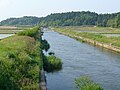
means "mountain". The source of the Kuriyama River is on the central Shimōsa Plateau in Narita or Sawara, Katori. Kurimoto, a former village in Katori,...
13 KB (1,284 words) - 23:26, 15 January 2022

kilometers from Narita International Airport. The terrain is part of the Shimosa Plateau, with an elevation of 20 to 30 meters. Chiba Prefecture Kashiwa Abiko...
12 KB (818 words) - 09:24, 12 April 2024
60 kilometers from the center of Tokyo. The city is located on the Shimosa Plateau, with an elevation of 14 to 70 meters above sea level. The geographic...
9 KB (568 words) - 07:28, 13 April 2024

Prefecture in the north by the Tone River. The city is located on the Shimosa Plateau, with an average elevation of about 20 meters above sea level. The...
14 KB (722 words) - 07:34, 30 March 2024