
circundante. Vea también: Category:SVG locator maps of countries in European Union (gray and green scheme) Category:SVG locator maps of countries of Europe...
(2,045 × 1,720 (7.32 MB)) - 12:10, 25 April 2023

|Author=[[User:HernauMan|HernauMan]] |Date=2009-05-15 |Permiss EU-United Kingdom.svg licensed with Cc-by-sa-3.0, GFDL 2009-10-23T15:07:42Z NuclearVacuum...
(590 × 603 (670 KB)) - 10:25, 16 September 2024

Uploaded with derivativeFX English Outline of the United Kingdom filled in blue with the flag of Europe superimposed...
(512 × 916 (348 KB)) - 14:08, 2 June 2023

Commons Attribution-Share Alike 4.0 truetrue English Location of the United Kingdom within the European Union in 2016. French Position du Royaume-Uni au...
(220 × 225 (40 KB)) - 17:50, 23 April 2021

projeksiyon)}} |Source=*[[:File:Syria_(orthographic_projection).svg|]] *[[:File:EU-Cyprus.svg|] EU-Cyprus.svg licensed with Cc-by-sa-3.0, GFDL 2013-07-01T08:46:11Z...
(553 × 553 (528 KB)) - 20:39, 10 December 2023
0 truetrue Separate licenses of Images used: EU-United Kingdom.svg, NuclearVacuum; CC-BY-SA-3.0 2016 EU Referendum HM Government Pamphlet.jpeg, Photograph...
(Ogg Theora/Vorbis video file, 51 s) - 16:08, 21 September 2020

File:UK and Dependencies.png (category SVG locator maps of countries of Europe (gray and green scheme))
Europe-United Kingdom.svg: MapLab Europe-Guernsey.svg: Rob984 Europe-Isle of Man.svg: Chipmunkdavis Europe-Jersey.svg: Maplab Gibraltar map-en.svg: Sting EU-Blank...
(2,045 × 1,720 (551 KB)) - 11:57, 23 April 2023

0 truetrue English 2014 European Parliamentary Election Map in the united kingdom author name string: Talleyrand6 Wikimedia username: Talleyrand6 URL:...
(1,050 × 1,220 (6.91 MB)) - 17:21, 20 July 2024

The UK (orange) and the European Union (blue) Swedish Storbrittanien och EU Portuguese Localização do Reino Unido na União Europeia Turkish Birleşik Krallık...
(593 × 606 (708 KB)) - 10:10, 27 December 2022

this work, hereby publish it under the following license: English Results of the 1979 EU Election in the UK by constituency determination method: SHA-1...
(544 × 630 (24.43 MB)) - 17:11, 27 August 2024

Quizimodo 2056x1710 (234175 Bytes) {{Information |Description=Location map: United Kingdom (dark green) / European Union (light green) / Europe (dark grey); inspired...
(2,185 × 1,835 (1.69 MB)) - 11:57, 23 April 2023

File:UK Regions.PNG (category Maps of regions of the United Kingdom)
the regions of England within the United Kingdom}} |Source=Own work by uploader, based on [[:File:2005UKElectionMap.svg]] |Date=2009-05-30 |Author=[[User:Ch1902|Ch1902]]...
(472 × 741 (105 KB)) - 12:26, 6 May 2022

following license: English Composition of seats representing the UK in the EU Parliament after the 2019 elections. author name string: Hellofromthedeep...
(360 × 185 (13 KB)) - 18:33, 13 September 2024

DescriptionEU-United Kingdom (orthographic projection).svg English: (Dark-Green) United Kingdom. (Light-Green) The rest of the European Union (EU). (Dark-gray)...
(2,000 × 2,000 (5.8 MB)) - 13:07, 23 April 2023
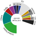
Illustrator. Data points used: United States 16799,7 China 13395,4 India 5069,2 Japan 4698,8 Germany 3232,6 United Kingdom 2390,9 France 2278,0 (gap) 8359...
(512 × 509 (21 KB)) - 21:38, 22 January 2024

versions Derivative works of this file: United Kingdom EU.svg: Brexit SVG development InfoField The SVG code is valid. This map was created with...
(675 × 1,180 (235 KB)) - 13:53, 2 July 2023

Commons Attribution-Share Alike 4.0 truetrue English Results of the 2019 EU Election in the UK by local authorities. author name string: Talleyrand6 Wikimedia...
(1,050 × 1,220 (6.78 MB)) - 17:21, 20 July 2024

choice. This image is a derivative work of the following images: File:EU-Czechia.svg licensed with Cc-by-sa-3.0, GFDL 2009-10-23T00:31:25Z NuclearVacuum...
(880 × 716 (134 KB)) - 21:01, 25 September 2022
Attribution-Share Alike 3.0 truetrue You may select the license of your choice. English EU and the Czech Republic Czech Poloha Česka na mapě Evropy. French Carte de...
(2,045 × 1,720 (7.33 MB)) - 21:50, 8 August 2024

original. https://creativecommons.org/licenses/by-sa/3.0CC BY-SA 3.0 Creative Commons Attribution-Share Alike 3.0 truetrue English Polish EU and Croatia...
(2,045 × 1,720 (7.33 MB)) - 08:55, 2 February 2024

DescriptionRoyal Coat of Arms of Greece.svg English: Coat of arms of the Kingdom of Greece in 1936–1973 Royal Coat of Arms of Greece under the Glücksburg...
(512 × 602 (2.1 MB)) - 19:22, 6 August 2024

This re-draw may not considered as a derivative work of File:EU visa lists.png. English...
(853 × 380 (1.26 MB)) - 18:06, 6 September 2023

This file has been extracted from another file : United Kingdom EU referendum 2016 area results (South West England & Gibraltar).svg...
(189 × 183 (13 KB)) - 02:14, 26 September 2022

Attribution-Share Alike 3.0 truetrue You may select the license of your choice. English EU and Poland French (V. foncé) Pologne. (V. clair) Reste UE. (G foncé) Reste...
(2,045 × 1,720 (7.33 MB)) - 03:39, 26 May 2023

DescriptionEuropean Parliament (United Kingdom) election 2009.svg English: map of the UK EU election 2009 Date 18 November 2012, 13:37:49 Source Own work...
(641 × 1,173 (157 KB)) - 22:55, 19 October 2020
Português: (Verde) Chipre. (Verde-claro) União Europeia (EU). (Cinzento) Europa. (Cinzento-claro) Paises circundantes. I, the copyright holder...
(2,045 × 1,720 (7.31 MB)) - 10:52, 28 October 2023

is rendered manually by T.seppelt based on the CSV-File User:T.seppelt/UK EU referendum polling.csv.}} I, the copyright holder of this work, hereby publish...
(900 × 630 (332 KB)) - 03:26, 28 August 2023

File:Individual skills training resource sheet package.pdf (matches file content)
Resource 11. Sheet 23 Using the EU opinion polling graph This is graph is found on [[Opinion polling for the United Kingdom European Union membership referendum]]...
(1,239 × 1,754 (1.75 MB)) - 20:58, 2 October 2020

0 truetrue You may select the license of your choice. English Belgium in EU French Localisation de la Belgique (vert foncé) en Union Européenne (vert...
(2,045 × 1,720 (7.33 MB)) - 08:14, 21 September 2024

Attribution-Share Alike 3.0 truetrue You may select the license of your choice. English EU and Italy and Rome French Carte de l'Union européenne, en vert clair, avec...
(2,045 × 1,720 (6.94 MB)) - 08:28, 10 August 2024