
derivativeFX English Map showing the approximate extent of the Akkadian Empire during the reign of Naram-Sin (2254-2218BCE short chronology, 2318-2282BCE...
(1,475 × 1,149 (2.34 MB)) - 01:03, 26 April 2024

Alike 4.0 truetrue English Map showing the approximate extension of the Akkad empire during the reign of Narâm-Sîn (2254-2218 B.C. in the short chronology)...
(1,475 × 1,149 (2.33 MB)) - 01:25, 19 February 2024
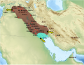
DescriptionEmpire akkad-pt.svg Português: Mapa do Império Acádio Date 4 November 2010 Source This file was derived from: Empire akkad.svg: Author Zunkir...
(1,475 × 1,149 (2.33 MB)) - 01:25, 19 February 2024

DescriptionEmpire akkad-ar.png العربية: خارطة تُظهر الحُدود التقريبيَّة للإمبراطوريَّة الأكديَّة خلال فترة حُكم نارام سين (مابين سنتيّ 2254-2218 ق.م تقريبًا)...
(1,475 × 1,149 (1.59 MB)) - 01:40, 20 February 2024

truetrue English Ancient Orient around 2200 BCE: Old Kingdom in Egypt / Empire of Akkad depicts: history of the Middle East point in time: 2200 BCE Wikimedia...
(2,102 × 1,510 (4.83 MB)) - 23:44, 10 August 2023

Kingdom of Egypt; main phase of pyramid building / Sargon establishes Akkad as Empire and invades Elam depicts: history of the Middle East point in time:...
(2,102 × 1,510 (4.65 MB)) - 23:44, 10 August 2023

derivative work of the following images: File:Middle_East_topographic_map-blank.svg licensed with Cc-by-sa-3.0,2.5,2.0,1.0, GFDL 2010-11-03T17:52:56Z Sémhur...
(1,434 × 1,036 (1.69 MB)) - 16:15, 5 November 2020

derivative work of the following images: File:Middle_East_topographic_map-blank.svg licensed with Cc-by-sa-3.0,2.5,2.0,1.0, GFDL 2010-11-03T17:52:56Z Sémhur...
(1,000 × 750 (5.68 MB)) - 06:22, 18 June 2022

Christus: Altes Reich in Ägypten; Hauptphase des Pyramidenbaus / Großreich Akkad author name string: Enyavar Wikimedia username: Enyavar URL: http://commons...
(2,102 × 1,510 (4.84 MB)) - 10:11, 7 December 2023

sites.svg Elam localisation.png Elam sites.png Empire akkad.png Empire akkad.svg Empire neo assyrien.svg Empire neo babyloien.svg Map of Akkad.svg Map of...
(3,097 × 1,938 (10.02 MB)) - 14:10, 25 June 2021

Christus: Altes Reich in Ägypten; Hauptphase des Pyramidenbaus / Sargon macht Akkad zur Großmacht, Einfall in Elam URL: https://commons.wikimedia.org/wiki/user:Enyavar...
(2,102 × 1,510 (4.65 MB)) - 10:11, 7 December 2023
DescriptionMap of Akkad.he.svg עברית: האימפריה האכדית Русский: Карта Аккада Date 8 March 2016 Source Map of Akkad.svg Middle_East_topographic_map-blank.svg Author...
(1,000 × 750 (5.68 MB)) - 21:24, 8 September 2022

derivative work of the following images: File:Near_East_topographic_map-blank.svg licensed with Cc-by-sa-3.0,2.5,2.0,1.0, GFDL 2009-08-18T18:31:37Z Sémhur...
(1,028 × 564 (674 KB)) - 19:47, 6 January 2023

(Mari/Ebla) File:First Eblaite Empire.png (Mari/Ebla) File:Second Eblaite Empire.png (Ebla/Akkad) 2300 File:Empire akkad.svg (Akkad vergleichsweise konservative...
(2,102 × 1,510 (8.63 MB)) - 09:25, 22 December 2023

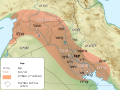
DescriptionBasse Mesopotamie Akkad.png Français : Carte des principales villes de la Basse Mésopotamie durant la période d'Akkad (v. 2300-2150 av. J.-C...
(440 × 393 (153 KB)) - 05:51, 4 November 2023

map-blank.svg File:Anatolie hittite.svg File:Assyrie general.PNG File:Babylone 1.PNG File:Basse Mesopotamie 1mil.png File:Basse Mesopotamie Akkad-Ur3.png...
(2,425 × 1,581 (2.33 MB)) - 23:59, 25 January 2024
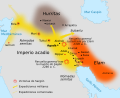
empty map. The information about extension comes from: Garelli, Paul: «Akkad», en El Próximo Oriente asiático. Barcelona: Labor 1974. ISBN 84-335-9310-2...
(587 × 480 (416 KB)) - 04:46, 10 November 2021

de Garelli, Paul: «Akkad», en El Próximo Oriente asiático. Barcelona: Labor 1974. ISBN 84-335-9310-2. Author File:Sargon de Acad.svg :Crates derivative...
(500 × 350 (379 KB)) - 06:42, 14 April 2023
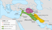
DescriptionOrientmitja2300aC-es.svg English: Middle East around 2300 BC. Español: Oriente Medio hacia el año 2300 a.C. Date 12 July 2018 (original upload...
(12,037 × 7,087 (927 KB)) - 20:27, 8 March 2023

toponyms 3000bc-en.svg English: Geographical map of the ancient Near East, with toponyms relating to the period of the Akkad Empire (late third millennium...
(1,426 × 1,083 (10.03 MB)) - 09:35, 21 September 2023

File:Orientmitja2300aC.png (category Sargon of Akkad)
using vector graphics as an SVG file. This has several advantages; see Commons:Media for cleanup for more information. If an SVG form of this image is available...
(850 × 500 (62 KB)) - 20:27, 8 March 2023

this map for the Oxus area this map for the Indus area this map for the Akkad Empire area this map for the China area this map for the Olmek area this map...
(1,871 × 991 (161 KB)) - 17:06, 28 May 2024