
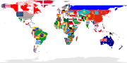
Australia is not shaded as it is considered to be a continent and not an island. English World map labelling island countries...
(863 × 443 (1.6 MB)) - 20:49, 2 August 2024
United Nations and merely an observer. 768 555 27 36 2400 1200 This is French Guiana. It's part of France. 720 972 189 81 2400 1200 These islands, including...
(2,400 × 1,200 (7.34 MB)) - 09:04, 13 October 2024

English: Island_nation countries as of 2005, based on Image:Landlocked_countries.png. 日本語:2005年現在の島国。Image:Landlocked_countries.pngを基にしています。 This file...
(1,427 × 628 (56 KB)) - 09:57, 6 June 2023

the Greenwich Prime Meridian and includes various en:microstates/en:island nations. All territories indicated in the UN listing of territories and regions...
(1,500 × 775 (194 KB)) - 16:49, 26 November 2023

member nations. Orange marked countries are test teams, yellow are associate and purple are affiliate member nations. (Note: Certain island nations may not...
(1,357 × 628 (77 KB)) - 10:01, 30 June 2024

image is a derivative work of the following images: File:Historical_nations_spain.svg licensed with PD-self 2010-07-06T09:46:08Z Mutxamel 2521x1808 (1213273...
(800 × 574 (95 KB)) - 11:34, 10 November 2020

the Greenwich Prime Meridian and includes various en:microstates/en:island nations. All territories indicated in the UN listing of territories and regions...
(1,500 × 775 (255 KB)) - 16:49, 26 November 2023

File:Solomon_island_-_Guadalcanal_-_Florida_map_-_en.svg English...
(1,060 × 896 (150 KB)) - 22:55, 13 October 2023

League of Nations Mandate - Pacific Ocean 08. Japanese Pacific Islands 09. British Solomon Islands 10. Australian New Guinea 11. Britain, Australia, and...
(200 × 172 (12 KB)) - 19:10, 26 September 2020

the island after the Holy Trinity. The island rising out of the waters beneath the Cocrico represents Tobago. Below these birds is the nation’s motto...
(770 × 713 (467 KB)) - 13:28, 23 March 2024

League of Nations Mandate (Pacific Ocean) Japanese Mandate of the Pacific Islands Australian Mandate of New Guinea Australian Mandate of Nauru New Zealand's...
(200 × 172 (6 KB)) - 02:53, 9 October 2020

{{BotMoveToCommons|en.wikipedia}} {{Information |Description={{en|Map of the island nation of the Republic of Nauru. English translation of map of Nauru made by...
(791 × 609 (107 KB)) - 21:08, 12 September 2020
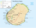
{{BotMoveToCommons|en.wikipedia}} {{Information |Description={{en|Map of the island nation of the Republic of Nauru. English translation of map of Nauru made by...
(791 × 609 (121 KB)) - 18:51, 23 October 2021

DescriptionIsland nations named.svg English: World Map showing island countries which are sovereign states and states with limited recognition, as listed...
(867 × 446 (1.62 MB)) - 08:59, 13 August 2021

{{BotMoveToCommons|en.wikipedia}} {{Information |Description={{en|Map of the island nation of the Republic of Nauru. English translation of map of Nauru made by...
(512 × 394 (51 KB)) - 16:41, 18 October 2020

Islands It is from openclipart.org, specifically british_virgin_islands.svg by Tobias Jakobs. Civil Ensign English Flag of the British Virgin Islands...
(1,200 × 600 (21 KB)) - 18:24, 19 January 2024

svg licensed with PD-self 2012-03-17T22:21:57Z Chris Bennett 940x477 (1646162 Bytes) Highlighted former realms which are small island states with...
(512 × 260 (1.58 MB)) - 02:24, 8 April 2024

Base: [[:File:Location European nation states.svg]]. Zoom insert derived from [[:File:Map of the Faroe Islands de.svg]]. 2011-02-22T11:24:44Z Chipmunkdavis...
(2,045 × 1,720 (4.51 MB)) - 21:52, 8 August 2024

Base: [[:File:Location European nation states.svg]]. Zoom insert derived from [[:File:Map of the Faroe Islands de.svg]]. 2011-02-22T11:24:44Z Chipmunkdavis...
(2,045 × 1,720 (7.34 MB)) - 11:57, 23 April 2023

|Description={{en|1=Map of the [[:en:Caribbean|Caribbean nations]].}} |Source=[[:File:BlankMap-World6.svg]]{{Inkscape}} |Author=[[User:NuclearVacuum|NuclearVacuum]]...
(1,750 × 700 (324 KB)) - 14:42, 13 June 2021

using gringer's perlshaper script, and Natural Earth Data (50m resolution). SVG source file edited with Inkscape. Parallels at 0, 15, 30, 45, 60, 70, 80...
(553 × 553 (1.3 MB)) - 08:46, 29 September 2024

hereby publish it under the following license: English Salomon Islands v Vanulatu, OFC Nations Cup Group A author name string: Falip Wikimedia username: Falip...
(534 × 738 (46 KB)) - 03:05, 4 July 2024

it under the following license: English New Zealand vs Salomon Islands, 2024OFC Nations Cup Group A author name string: Falip Wikimedia username: Falip...
(534 × 738 (57 KB)) - 03:16, 4 July 2024

flag.svg: AUGLÝSING um liti íslenska fánans.. PMO. English Flag of Iceland Norwegian Islands flagg Simplified Chinese 冰岛国旗 German Flagge Islands Norwegian...
(1,250 × 900 (281 bytes)) - 03:25, 8 July 2024

Signsolid 2753×1400× (159141 bytes) The Commonwealth of Nations 2007-04-20 17:44 Signsolid 2753×1400× (159126 bytes) The Commonwealth of Nations English...
(2,753 × 1,400 (156 KB)) - 09:42, 26 October 2022

570 300 The flag of the Marshall Islands has the greatest number of star points. English Flag of the Marshall Islands Portuguese Bandeira das Ilhas Marshall...
(1,140 × 600 (790 bytes)) - 18:01, 18 August 2024

Location map for the Caribbean island-nation of Dominica. Originally created for English Wikipedia by Vardion. . English...
(290 × 133 (4 KB)) - 08:43, 6 June 2023

File:Map of the Caribbean-Greater Antilles.png (category Locator maps of islands in the Caribbean)
|Description={{en|1=Map of the [[:en:Caribbean|Caribbean nations]].}} |Source=[[:File:BlankMap-World6.svg]]{{Inkscape}} |Author=[[User:NuclearVacuum|NuclearVacuum]]...
(800 × 565 (33 KB)) - 07:10, 21 September 2024

checked. English Flag of the United States Virgin Islands British English Flag of the Virgin Islands, United States of America. Russian Флаг Виргинских...
(1,275 × 850 (20 KB)) - 06:16, 23 September 2024

original 2007-01-19 22:18 Bobo is soft 791×609×0 (940674 bytes) Map of the island nation of the Republic of Nauru. <Br>English translation of map of Nauru made...
(791 × 609 (106 KB)) - 14:28, 31 October 2022