
work of the following images: Image:Pacific_Area_-_The_Imperial_Powers_1939_-_Map.svg licensed with Cc-by-sa-3.0, GFDL 2008-08-08T01:16:33Z Emok 1039x814...
(634 × 387 (2.27 MB)) - 08:25, 21 May 2024

Imperial Powers 1939 - Map - ru.svg}} }} {{Image Image:Pacific_Area_-_The_Imperial_Powers_1939_-_Map.jpg Uploaded with derivativeFX English A map of the Imperial...
(1,039 × 814 (4.49 MB)) - 16:52, 14 November 2023

DescriptionManchukuo map 1939-es.svg English: A map of the Manchukuo, 1939-09-01. Dates shown indicate the approximate year that Japan gain control of...
(634 × 387 (1.32 MB)) - 19:42, 22 April 2023
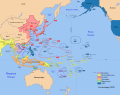
Area - The Imperial Powers 1939 - Map - ru.svg}} }} {{Image Image:Pacific_Area_-_The_Imperial_Powers_1939_-_Map.jpg Uploaded with derivativeFX English...
(1,039 × 814 (4.43 MB)) - 09:38, 25 August 2023

work of the following images: Image:Pacific_Area_-_The_Imperial_Powers_1939_-_Map.svg licensed with Cc-by-sa-3.0, GFDL 2008-08-21T02:54:43Z Emok 1039x814...
(634 × 387 (2.23 MB)) - 10:02, 22 May 2024

Türkçeleştirilmiş hali. |kaynak=http://en.wikipedia.org/wiki/Image:Manchukuo_map_1939.svg |tarih= |yazar= |izinler= |diğer_sürümler= }} ==Lisans== {{KM-Kişisel}}...
(634 × 387 (2.21 MB)) - 10:43, 14 November 2021

haritası.svg English: Maps of the Empire of Japan (in Turkish) Türkçe: Japon İmpataratorluğu haritası Date 28 August 2021 Source Manchukuo map 1939.svg Author...
(634 × 387 (2.17 MB)) - 01:35, 26 December 2022

DescriptionMap of Manchukuo divisions en.svg English: Map of Manchukuo administrative divisions (1934-1939). Date 13 December 2014 Source Own work Author...
(651 × 726 (206 KB)) - 15:48, 15 October 2020

DescriptionMap of Manchukuo divisions zh-hans.svg English: Map of Manchukuo administrative divisions (1934-1939). Date 13 December 2014 Source Own work...
(651 × 726 (237 KB)) - 16:32, 18 June 2024

DescriptionMap of Manchukuo divisions zh-hant.svg English: Map of Manchukuo administrative divisions (1934-1939). Date 13 December 2014 Source Own work...
(651 × 726 (252 KB)) - 16:52, 10 November 2022

DescriptionKorea map 1939.svg English: Map of 1939, showing Colonial Korea (highlighted), and other Japanese territories and colonies, under rule of the...
(634 × 387 (2.23 MB)) - 07:01, 24 March 2024

December 2008 Source modification of File:Mengjiang map 1939.svg Author Bamse Other versions = Taiwan (català) Pacific Area Korea Manchukuo Mengjiang Taiwan...
(634 × 387 (2.17 MB)) - 23:54, 9 June 2024