
Southeast Slovenia Statistical Region (redirect from Jugovzhodna Slovenija)
Southeast Slovenia Statistical Region (Slovene: statistična regija jugovzhodna Slovenija) is a statistical region in southeast Slovenia. It is the largest...
9 KB (423 words) - 00:05, 12 January 2024

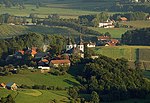
shifted to nearby Mirna. It is the seat of the Municipality of Šentrupert. The name Šentrupert means 'Saint Rupert', referring to the local parish church...
9 KB (498 words) - 18:39, 21 August 2024
Prelesje (pronounced [pɾɛˈleːsjɛ]) is a settlement in the Municipality of Šentrupert in southeastern Slovenia. The area is part of the historical region of...
4 KB (72 words) - 17:20, 23 August 2024
settlement south of Šentrupert in the historical region of Lower Carniola in southeastern Slovenia. The Municipality of Šentrupert is now included in the...
4 KB (56 words) - 17:20, 23 August 2024

Trstenik (pronounced [təɾstɛˈniːk]) is a settlement in the Municipality of Šentrupert in southeastern Slovenia. It lies just northeast of Mirna in the historical...
5 KB (120 words) - 17:21, 23 August 2024
Škrljevo (pronounced [ʃkəɾˈljeːʋɔ]) is a settlement just west of Šentrupert in southeastern Slovenia. The area is part of the historical region of Lower...
5 KB (152 words) - 17:21, 23 August 2024
Republic of Slovenia". Stat.si. Retrieved 2012-11-20. "Šentrupert municipal site". Sentrupert.si. Archived from the original on 2012-05-25. Retrieved...
5 KB (139 words) - 17:20, 23 August 2024

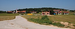
Municipality of Šentrupert (Slovene: Občina Šentrupert) is a municipality in southeastern Slovenia. The seat of the municipality is the town of Šentrupert. The area...
6 KB (236 words) - 10:50, 24 August 2024

dispersed settlement in the Municipality of Šentrupert in southeastern Slovenia. It lies in the hills west of Šentrupert and north of Mirna. The area is part...
4 KB (96 words) - 17:21, 23 August 2024
settlement east of Šentrupert in the historical region of Lower Carniola in southeastern Slovenia. The Municipality of Šentrupert is now included in the...
4 KB (48 words) - 17:21, 23 August 2024
is a settlement in the Municipality of Šentrupert in southeastern Slovenia. It lies on the road from Šentrupert towards Mirna in the historical region...
5 KB (123 words) - 17:21, 23 August 2024
village in the Municipality of Šentrupert in southeastern Slovenia. It is a dispersed settlement in the hills north of Šentrupert in the historical region of...
4 KB (67 words) - 17:20, 23 August 2024
belongs to the Parish of Šentrupert. It dates to the mid-15th century with some 17th-century remodelling. "Okrog, Šentrupert". Place Names. Statistical...
5 KB (123 words) - 17:20, 23 August 2024

settlement in the hills west of Šentrupert in the historical region of Lower Carniola in Slovenia. The Municipality of Šentrupert is now included in the Southeast...
4 KB (51 words) - 17:21, 23 August 2024
Gorenje Jesenice (category Jugovzhodna Slovenija statistical region geography stubs)
jɛsɛˈniːtsɛ]; German: Oberjessenitz) is a village in the Municipality of Šentrupert in southeastern Slovenia. The area is part of the historical region of...
5 KB (159 words) - 17:20, 23 August 2024
just north of Šentrupert in southeastern Slovenia. The area is part of the historical region of Lower Carniola. The Municipality of Šentrupert is now included...
4 KB (61 words) - 17:20, 23 August 2024
Vesela Gora (category Jugovzhodna Slovenija statistical region geography stubs)
(pronounced [ʋɛˈseːla ˈɡɔːɾa]) is a small settlement in the Municipality of Šentrupert in southeastern Slovenia. The area is part of the historical region of...
6 KB (163 words) - 17:21, 23 August 2024
Hrastno (category Jugovzhodna Slovenija statistical region geography stubs)
hills northeast of Šentrupert in the historical region of Lower Carniola in southeastern Slovenia. The Municipality of Šentrupert is now included in the...
4 KB (59 words) - 17:20, 23 August 2024
Mali Cirnik pri Šentjanžu (category Jugovzhodna Slovenija statistical region geography stubs)
is a village in the Municipality of Šentrupert in southeastern Slovenia. It lies in the hills east of Šentrupert just off the road towards Šentjanž in...
6 KB (234 words) - 17:20, 23 August 2024
Draga pri Šentrupertu (category Jugovzhodna Slovenija statistical region geography stubs)
northwest of Šentrupert in southeastern Slovenia. The area is part of the historical region of Lower Carniola. The Municipality of Šentrupert is now included...
5 KB (147 words) - 17:20, 23 August 2024
Ravne nad Šentrupertom (category Jugovzhodna Slovenija statistical region geography stubs)
in the hills north of Šentrupert in the Lower Carniola region of southeastern Slovenia. The entire Municipality of Šentrupert is included in the Southeast...
4 KB (84 words) - 17:20, 23 August 2024
Rakovnik pri Šentrupertu (category Jugovzhodna Slovenija statistical region geography stubs)
Kroisenbach) is a village in the Municipality of Šentrupert in southeastern Slovenia. It lies south of Šentrupert and east of Mirna in the historical region...
5 KB (151 words) - 17:21, 23 August 2024
Roženberk (category Jugovzhodna Slovenija statistical region geography stubs)
is a small settlement north of Dolenje Jesenice in the Municipality of Šentrupert in southeastern Slovenia. The area is part of the historical region of...
4 KB (92 words) - 17:21, 23 August 2024

Zaloka (category Jugovzhodna Slovenija statistical region geography stubs)
(Slovene: sveta Neža) and belongs to the Parish of Šentrupert. It dates to the 16th century. "Zaloka, Šentrupert". Place Names. Statistical Office of the Republic...
5 KB (105 words) - 17:20, 23 August 2024
Dolenje Jesenice (category Jugovzhodna Slovenija statistical region geography stubs)
German: Unterjessenitz) is a small settlement in the Municipality of Šentrupert in southeastern Slovenia. The area is part of the historical region of...
4 KB (87 words) - 17:20, 23 August 2024