
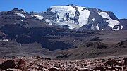
Ojos del Salado (redirect from Nevado Ojos del Salado)
deposits on its flanks. The mountain is often referred to as Cerro Ojos del Salado and Nevado Ojos del Salado; the former is a common term for "mountain"...
83 KB (9,597 words) - 17:30, 14 October 2024
the height of each mountain. Aconcagua (Mendoza) 6,962 m (22,841 ft) Nevado El Plomo 6,070 m (19,910 ft) Cerro Ameghino approx. 5,940 m (19,490 ft) Ojos...
3 KB (359 words) - 22:34, 10 June 2024

Nevado Tres Cruces is a massif of volcanic origin in the Andes Mountains on the border of Argentina and Chile. It has two main summits, Tres Cruces Sur...
34 KB (3,678 words) - 16:23, 25 June 2024

Pucón Bosque Nevado, Huilo-Huilo, Panguipulli (permanently closed) Antillanca, Puyehue Volcán Osorno, Puerto Varas El Fraile, Coyhaique Cerro Mirador, Punta...
4 KB (230 words) - 04:42, 1 May 2024
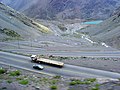
Santiago, Chile, to Mendoza, Argentina, on 16 July 1932, the Pan American-Grace Airways (Panagra) Ford Trimotor San José crashed on Cerro El Plomo during...
4 KB (324 words) - 16:36, 20 July 2021
(17,454 ft) Nevado del Cumbal, 4,764 m (15,630 ft) Cerro Negro de Mayasquer, 4,445 m (14,583 ft) Ritacuba Blanco, 5,410 m (17,749 ft) Nevado del Quindío...
60 KB (6,962 words) - 12:21, 23 September 2024

Tupungato (redirect from Cerro Tupungato)
(1961). "Contribución al Conocimiento de la Petrografía del Cerro Tupungato (Provincia de Mendoza) y de otras Rocas Efusivas de la Región". Dirección Nacional...
6 KB (405 words) - 21:36, 22 September 2024

Incahuasi (redirect from Nevado de Incahuasi)
close to Incahuasi are Falso Azufre and Nevado San Francisco, as well as the Miocene Cerro Morocho and Cerro Ojo de Las Lozas volcanoes. It has been suggested...
22 KB (2,314 words) - 05:48, 15 August 2024
massifs of Cerro Aconcagua 6,962 metres (22,841 ft), Cerro Tupungato 6,550 metres (21,490 ft) and Nevado Juncal 6,110 metres (20,050 ft) are situated deca-kilometres...
7 KB (869 words) - 18:45, 16 April 2023

visible from Cerro Paranal, 190 km away as measured through Google Maps. The view from the mountain extends from Licancabur north over the Nevados de Cachi...
104 KB (11,676 words) - 09:05, 1 September 2024

Nevado de Cachi is the name given to a large complex of mountains that lies in Salta Province, Argentina. This complex counts several summits, the highest...
2 KB (214 words) - 16:18, 25 June 2024
Marmolejo (redirect from Cerro Marmolejo)
Piuquenes. It is on the border of two provinces: Argentinean province of Mendoza and Chilean province of Cordillera. Its slopes are within the administrative...
7 KB (480 words) - 04:44, 1 September 2024
Cayambe Cerro Ayapungo Cerro Hermoso Chimborazo Collay Cotopaxi El Altar Illiniza Sur Quilindaña Sangay Saraurcu Sincholagua Nevado de Santa Isabel Nevado del...
13 KB (1,197 words) - 09:17, 25 June 2024

Nevado Juncal is a mountain at the border of Argentina and Chile, at the head of Aconcagua Val. It has a height of 5,953 metres (19,531 ft). It is located...
5 KB (328 words) - 09:00, 7 February 2024

plateau in Bolivia, and the caldera complexes of Incapillo and Cerro Galán in Argentina. Nevados de Chillán (2003) Copahue (2000) Lonquimay (1990) Llaima (2008–2009)...
23 KB (2,748 words) - 01:43, 15 August 2024
to the Dominance System and its dominance is 23.96%. Its parent peak is Nevado del Plomo and the Topographic isolation is 21 kilometers. "Polleras". Andes...
4 KB (333 words) - 20:16, 27 September 2023
guide on Cerro Aconcagua (6962 m), the highest mountain in America. In 1999, she summited Argentina's Monte Pissis volcano. Later climbed Nevado Sajama...
4 KB (389 words) - 18:12, 22 September 2024
Cerro Olascoaga Agua Negra Pass Nevado de Olivares Libertadores Pass El Plomo Tupungato San José Volcano Nevado Piquenes Picos de Barroso Maipo Cerro...
10 KB (594 words) - 08:56, 11 October 2024
volcanic eruptions in this area were the 1932 Quizapu and the 1991 Cerro Hudson eruptions. Nevado de Longaví is usually put into the "Transitional Southern Volcanic...
24 KB (2,586 words) - 18:18, 23 August 2024

Colombia. It is the capital of the Department of Caldas, and lies near the Nevado del Ruiz volcano. Currently, the city is the main center for the production...
26 KB (2,178 words) - 18:00, 24 September 2024

Monte Pissis (redirect from Nevado Pissis)
volcanic centre. It was formed between 6.6 and 6.2 million years ago. Like Cerro Bonete Chico it is one of the large volcanic complexes formed at that time...
10 KB (1,010 words) - 04:44, 1 September 2024

San José (volcano) (category Mountains of Mendoza Province)
Northern Volcanic Zone (6° N – 3° S) Paipa-Iza Romeral Cerro Bravo Nevado del Ruiz Nevado del Tolima Nevado del Huila Puracé Doña Juana Galeras Azufral Chiles...
2 KB (161 words) - 16:40, 27 June 2022
al Sur, Mafil (CHI) 1st in Stage 9 Vuelta Ciclista Lider al Sur, Valle Nevado (CHI) 2nd in General Classification Vuelta Ciclista Lider al Sur (CHI) Chile...
7 KB (554 words) - 22:32, 28 June 2024

Payún Matrú (category Volcanoes of Mendoza Province)
beneath the South American Plate. Payún Matrú, along with the Llancanelo, Nevado and Salado Basin volcanic fields, form the Payenia province. It has been...
63 KB (7,018 words) - 12:52, 29 July 2024

meters (0 to 14,110 ft) above sea level, from the coast to the top of the Nevado de Colima. The Jalisco area contains all five of Mexico's natural ecosystems:...
145 KB (13,149 words) - 22:57, 26 September 2024

Sillajhuay (redirect from Cerro Sillajguay)
Gerhard; Harmon, Russell S.; Lopez-Escobar, Leopoldo (1 September 1990). "The Nevados de Payachata volcanic region (18°S/69°W, N. Chile) II. Evidence for widespread...
35 KB (3,807 words) - 22:50, 5 January 2024

forms Cerro Onas, while a more recent one occurs in the Quebrada de las Cuevas area. Between Cerro de la Aguada and Cerro Cajeros lies the Cerro la Botijuela...
41 KB (4,653 words) - 02:42, 8 July 2024
(Ontario/Quebec) Noranda Caldera (Quebec) Colombia Arenas crater caldera, Nevado del Ruiz volcano, Caldas Department Laguna Verde caldera, Azufral volcano...
43 KB (4,402 words) - 11:51, 11 October 2024

southern Chile. After a failed attempt in 1553, governor García Hurtado de Mendoza founded the city of Osorno in 1558, the only Spanish settlement in the...
30 KB (3,172 words) - 02:11, 7 October 2024
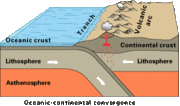
erosion. At the latitudes of 32–36° S —that is Central Chile and most of Mendoza Province— the Andean orogeny proper began in the Late Cretaceous when backarc...
53 KB (4,956 words) - 13:17, 16 September 2024