
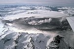
Wikimedia Commons has media related to Cerro del Azufre. Cerro del Azufre (Spanish pronunciation: [ˈsero ðel aˈsufɾe]) is a stratovolcano located in El...
15 KB (1,669 words) - 08:05, 15 August 2024

1 by 1.3 kilometres (0.62 mi × 0.81 mi) wide. The highest summit Cerro Falso Azufre lies at the western end in Chile, which has mostly generated pyroclastic...
6 KB (740 words) - 04:52, 29 January 2024

edifices of Cerro Solo, El Fraile, Incahuasi, El Muerto, El Muertito, Falso Azufre, Nevado San Francisco, Nevado Tres Cruces and Ojos del Salado, which...
83 KB (9,597 words) - 10:34, 18 September 2024

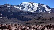
Cordón del Azufre is an inactive complex volcano located in the Central Andes, at the border of Argentina and Chile. It consists of three stages of volcanic...
19 KB (2,226 words) - 22:07, 28 August 2024
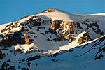
age is 1.5±0.1 mya. The dome is located on the northwestern side of Cerro del Azufre. It is constructed from three lobes with diameters of 1.5 kilometres...
2 KB (248 words) - 08:09, 30 January 2024
Falso Azufre 5,890 19,324 Argentina/Chile Ollagüe 5,868 19,252 Bolivia/Chile Taapaca 5,860 19,226 Chile San José 5,856 19,213 Argentina/Chile Cerro del Azufre...
37 KB (59 words) - 10:13, 2 August 2024
Cerro de La Isla, Antofagasta Region Cerro del Azufre, stratovolcano, Antofagasta Region Cerro de las Cuevas, volcano, Antofagasta Region Cerro del León...
23 KB (2,785 words) - 01:42, 28 August 2024

ground uplift encompassing also the more northerly Lastarria and Cordón del Azufre volcanoes. The 5,401-metre (17,720 ft) high summit is the source of two...
6 KB (540 words) - 19:54, 23 January 2024
Antillanca Group, in the background: Puntiagudo and Osorno Aerial view of Cerro Azul Rano Kau crater on Easter Island Poike volcano, in the foreground,...
39 KB (596 words) - 12:01, 17 January 2024
Barrancas Blancas Azufre Bayo Colorados Copiapó El Muerto El Ermitaño El Fraile El Toro Falso Azufre Incahuasi Mulas Muertas Ojos del Salado Peña Blanca...
9 KB (268 words) - 14:17, 13 November 2023

Condorito (which is considered to be part of the old El Cóndor volcano), Falso Azufre and Laguna Escondida which have constrained the extent of El Cóndor's lava...
6 KB (647 words) - 16:19, 25 June 2024
Hudson Volcano (redirect from Cerro Hudson)
Hudson Volcano (Spanish: Volcán Hudson, Cerro Hudson, or Monte Hudson) is the most active volcano in the southern part of the Southern Volcanic Zone of...
80 KB (8,906 words) - 17:50, 23 August 2024
Ojos del Salado region. It is surrounded by Miocene and Pliocene volcanoes, but there also are Quaternary volcanoes in the area such as Falso Azufre west-southwest...
5 KB (443 words) - 09:54, 15 January 2024

the Puna and extends west-southwestwards from Cerro Blanco to the volcanoes San Francisco and Falso Azufre and the Paso de San Francisco. It marks the boundary...
81 KB (9,278 words) - 11:41, 15 August 2024
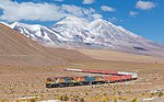
passenger service is provided today except south of Oruro with the Wari Wari del Sur running several times a week and serving several stations en route. The...
13 KB (1,559 words) - 07:38, 2 February 2024
ISSN 0038-2353. Bertagni, Aníbal (1939). Manifestaciones Superficiales de Azufre en el Cerro Tuzgle – Departamento de Susques, Territorio Nacional de Los Andes...
43 KB (4,986 words) - 12:26, 15 August 2024
Cerro El Plomo is a mountain in the Andes near Santiago, Chile. With an elevation of 5,434 m (17,783 ft), it is the largest peak visible from Santiago...
4 KB (324 words) - 16:36, 20 July 2021

Geographische Mitteilungen (in German). 5. "Copiapo / Cerro Azufre". Andes Specialists. Retrieved 2020-04-12. "Cerro Azufre, Chile" on Peakbagger v t e...
7 KB (570 words) - 09:03, 10 May 2023

Incahuasi (redirect from Cerro de Incahuasi)
located close to Incahuasi are Falso Azufre and Nevado San Francisco, as well as the Miocene Cerro Morocho and Cerro Ojo de Las Lozas volcanoes. It has...
22 KB (2,314 words) - 05:48, 15 August 2024
Cerro Guacha is a Miocene caldera in southwestern Bolivia's Sur Lípez Province. Part of the volcanic system of the Andes, it is considered to be part...
25 KB (3,121 words) - 14:23, 14 September 2024

and Laguna Hedionda, from which is separated by the crest of the Cerros de Cañapa, Cerro Araral and others. To the south, the basin is bordered by the San...
2 KB (251 words) - 00:39, 15 September 2024

Nevado del Ruiz (Spanish pronunciation: [neβaðo ðel ˈrwis]), also known as La Mesa de Herveo (English: Mesa of Herveo, the name of the nearby town) is...
52 KB (5,869 words) - 10:22, 17 August 2024

Cerro Toco is a stratovolcano located in the eastern part of the Atacama desert in Chile's II Region (Antofagasta), approximately 6 km (4 mi) south of...
2 KB (151 words) - 21:49, 20 November 2023

Hirochika; Nagao, Keisuke (4 April 2018). "Eruptive history of Incahuasi, Falso Azufre and El Cóndor Quaternary composite volcanoes, southern Central Andes". Bulletin...
104 KB (11,676 words) - 09:05, 1 September 2024

Tupungato (redirect from Cerro Tupungato)
Díaz, Emilio F. (1961). "Contribución al Conocimiento de la Petrografía del Cerro Tupungato (Provincia de Mendoza) y de otras Rocas Efusivas de la Región"...
6 KB (405 words) - 21:36, 22 September 2024

Apacheta-Aguilucho volcanic complex (redirect from Cerro Pabellón)
axis of the graben is buried beneath other volcanoes starting with Cerro del Azufre which form a northwest–southeast alignment known as Inacaliri lineament...
29 KB (3,298 words) - 03:23, 29 July 2024
Marmolejo (redirect from Cerro Marmolejo)
Nacional". www.ign.gob.ar. Retrieved 2020-04-30. rbenavente. "Biblioteca del Congreso Nacional | SIIT | Mapas vectoriales". bcn.cl. Retrieved 2020-04-30...
7 KB (480 words) - 04:44, 1 September 2024
separates Argentina from Chile along the Andes and on the islands of Tierra del Fuego. However, there are some border disputes, particularly around the Southern...
10 KB (594 words) - 04:23, 2 July 2024
at 6,130 metres (20,110 ft) is called Cerro Queva or El Queva. The two other centres are named Gordo and Azufre, with some additional minor centres. These...
11 KB (1,328 words) - 14:19, 14 September 2024

Cerro Azul (Spanish pronunciation: [ˈsero aˈsul], blue hill in Spanish), sometimes referred to as Quizapu, is an active stratovolcano in the Maule Region...
28 KB (3,338 words) - 04:48, 16 August 2024