
Charruba or Kharruba (Arabic: الخروبة) is a village in Libya. It is located 66 kilometres (41 mi) south of Al Marj, and 186 kilometres (116 mi) west of...
5 KB (58 words) - 18:48, 26 March 2020

Charruba-Timimi road is an asphalt road in the Cyrenaica region of eastern Libya running from Charruba to Taban, Mechili, and Timimi. It's about 186 kilometres...
2 KB (159 words) - 11:51, 15 July 2024
distance was shortened to 450 km (280 mi) after the construction of the Charruba–Timimi Road between the years 1975 and 1985. Construction of the Tobruk–Ajdabiya...
26 KB (2,278 words) - 00:16, 13 September 2024
situation improved after the Charruba–Timimi Road was paved between 1975 and 1985; it is now at the crossroads of the Charruba–Timimi Road and the Derna-Tobruk...
7 KB (321 words) - 19:13, 4 February 2024

The other runs through Tacnis and Marawah. From Tacnis it leads to the Charruba–Timimi Road. List of cities in Libya Wolfram Alpha Room, Adrian (2006)...
6 KB (525 words) - 03:00, 23 June 2024
from Suluq on the same direction. There is another road linking her with Charruba (about 69 km (43 mi) to the north). Msus was a site of several battles...
5 KB (118 words) - 08:32, 25 June 2024
Reconnaissance Unit 3 was stopped by the 2nd Support Group artillery west of Charruba and Group Olbrich reached Antelat, with a machine-gun unit having pressed...
69 KB (8,819 words) - 15:05, 12 June 2024

El Ezzeiat is a village in eastern Libya on the Charruba–Timimi Road. It is located 40 km (25 mi) east of Timimi and 40 km west of Mechili. Wikimedia Commons...
5 KB (40 words) - 13:41, 17 March 2017
Libyan Coastal Highway. There also an indirect road connecting it with Charruba to the south. It is the birthplace of Hussein Maziq, a Libyan politician...
5 KB (110 words) - 00:43, 17 November 2017

highways in Cyrenaica and Tripolitania. They include: Ajdabiya–Kufra Road Charruba–Timimi Road Fezzan Road Tobruk–Ajdabiya Road Tripoli – Cape Town Highway...
8 KB (900 words) - 19:05, 1 April 2023

the past from isolation. However, its isolation ended after paving the Charruba–Timimi desert road between the years 1975–1985, and this road became the...
7 KB (319 words) - 21:42, 17 December 2020
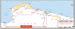
a British patrol and was directed to a concentration of troops in the Charruba area, including the column containing B Company. Next day a further withdrawal...
28 KB (3,530 words) - 21:49, 3 March 2024

day, divisional artillery fire halted German reconnaissance forces near Charruba. At midday, Lieutenant-General Richard O'Connor (GOC British Troops in...
60 KB (7,820 words) - 13:59, 17 June 2024
Akhdar in north-eastern Libya. It is located on the cross-roads between the Charruba–Mechili–Timimi desert road and the Marawa–Wadi Sammalus. Between February...
5 KB (95 words) - 12:41, 1 February 2019

by this flanking movement. By 20 December 7th Support Group had reached Charruba and was in contact with the rear of the Ariete and Trieste Divisions, though...
75 KB (10,250 words) - 22:48, 14 January 2024