Sladun Peninsula (redirect from Cierva Point)
2 mi) into Gerlache Strait south of Cierva Cove and north of Duarte Cove. It ends in Cierva Point and Sucia Point to the west. The feature is named after...
6 KB (741 words) - 22:55, 2 August 2024
The Cierva Point and offshore islands Important Bird Area is a 6540 ha tract of land and sea on the Danco Coast of the Antarctic Peninsula. The Important...
3 KB (345 words) - 02:46, 10 June 2022
Foster Group's principal outcrops are located at South Point, Cathedral Crags near Entrance Point and north of Punta de la Descubierta forming spectacular...
39 KB (4,065 words) - 11:57, 20 July 2024

oceanicus) en Punta Cierva, Costa de Danco, peninsula Antarctica [Nesting habitat of Wilson's Petrel (Oceanites oceanicus) at Cierva Point, Danco, Antarctic...
17 KB (1,882 words) - 19:11, 1 July 2024
Hope Bay (redirect from Sheppard Point)
them for its association with Sheppard Point. 63°22′S 56°58′W / 63.367°S 56.967°W / -63.367; -56.967. A point marking the north side of the entrance...
19 KB (2,867 words) - 23:37, 11 August 2024

Hut Point Peninsula (77°47′S 166°51′E / 77.783°S 166.850°E / -77.783; 166.850) is a long, narrow peninsula from 2 to 3 nautical miles (3.7 to 5.6 km;...
16 KB (2,687 words) - 05:54, 8 July 2024

Juan de la Cierva y Codorníu, 1st Count of la Cierva ([ˈxwan de la ˈθjeɾβaj koðoɾˈni.u]; 21 September 1895 – 9 December 1936), was a Spanish civil engineer...
17 KB (1,885 words) - 23:11, 12 August 2024

Striation Valley Graham Land Apéndice Island Avian Island Biscoe Point Bransfield Strait Cierva Point Dion Islands Eastern Dallmann Bay Emperor Island Green Island...
5 KB (408 words) - 09:36, 7 February 2023

Petermann Island (redirect from Depeaux Point)
coordinates) 65°10′S 64°11′W / 65.167°S 64.183°W / -65.167; -64.183. A point forming the northwest end of Petermann Island,. Charted by the FrAE, 1908-10...
14 KB (1,941 words) - 23:44, 11 August 2024

Adelaide Island (redirect from Mothes Point)
1976–77. The point was named by UK-APC in 1978 for BAS builder Donald C. Mackay. The Mackay Point is a tiny peninsula (450 m at its widest point) protruding...
11 KB (1,362 words) - 21:23, 29 April 2024

Signy Island (redirect from Jebsen Point)
Foca Point also marks the north side of Foca Cove, named in association with the point. The next significant feature is Thulla Point, an ice-free point lying...
21 KB (2,830 words) - 21:59, 1 December 2023

Fildes Peninsula (redirect from Halfthree Point)
which is permanently covered by ice. Its southeastern end is a point called Halfthree Point. It was charted and named by Discovery Investigations personnel...
4 KB (477 words) - 15:57, 20 January 2024

Cape Evans (redirect from Tryggve Point)
around Cape Evans include North Bay, South Bay, Cape Evans Hut, Tryggve Point, Turks Head Bay, Turks Head, Inaccessible Island, Tent Island, Dellbridge...
7 KB (1,027 words) - 15:39, 14 February 2024

Bay is an irregular bay, 8 km (5 mi) wide at its entrance between Demay Point and Martins Head, indenting the southern coast of King George Island for...
5 KB (430 words) - 22:16, 20 January 2024

Cape Royds (redirect from Newport Point)
a hut at Cape Royds, a small promontory twenty-three miles north of Hut Point where Scott had stayed during the Discovery Expedition. The whole shore...
12 KB (1,875 words) - 13:08, 29 March 2024
Island Bates Island Brash Island Brown Bluff Cape Evensen Cape Wollaston Cierva Point Cockburn Island Cormorant Island Cuverville Island D'Urville Monument...
4 KB (295 words) - 03:37, 27 July 2024

Clark Peninsula (redirect from Stonehocker Point)
extremity, Blakeney Point. It was named by US-ACAN for A. A. Blakeney, photographer's mate on Operation Highjump. Whitney Point is a rocky point that marks the...
8 KB (935 words) - 14:17, 1 February 2024

Cape Crozier (redirect from Wood Point (Antarctica))
169°24′E / 77.517°S 169.400°E / -77.517; 169.400) is the most easterly point of Ross Island in Antarctica. It was discovered in 1841 during James Clark...
13 KB (1,571 words) - 04:48, 29 May 2024

(0.62 mi) crater or caldera sits at the top of the volcano. The highest point of the volcano lies east-northeast of the caldera and reaches 2,733 metres...
84 KB (9,332 words) - 06:42, 20 April 2024

Peak in the central mountains to the coast between Conception Point in the west to Foul Point in the east. Most of the land in the site is covered by glacial...
5 KB (532 words) - 18:15, 4 June 2023
Narębski Point is a headland on the south-east coast of the Barton Peninsula, at the south-western end of King George Island, in the South Shetland Islands...
2 KB (199 words) - 22:39, 5 February 2023

Island Bates Island Brash Island Brown Bluff Cape Evensen Cape Wollaston Cierva Point Cockburn Island Cormorant Island Cuverville Island D'Urville Monument...
6 KB (475 words) - 16:59, 6 April 2024

(16 mi) southeast of Buckle Island and 95 km (59 mi) north-east of Belousov Point on the Antarctic mainland. The island, in Oates Land, also forms part of...
4 KB (301 words) - 19:26, 5 January 2024

The Cierva C.4 was an experimental autogiro built by Juan de la Cierva in Spain in 1922 which early the following year became the first autogyro to fly...
4 KB (459 words) - 07:40, 9 March 2024

Island Bates Island Brash Island Brown Bluff Cape Evensen Cape Wollaston Cierva Point Cockburn Island Cormorant Island Cuverville Island D'Urville Monument...
3 KB (225 words) - 11:19, 20 March 2024
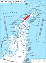
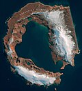
offshore islands, Danco Coast, Antarctic Peninsula Cierva Point is located on the south coast of Cierva Cove, to the north of Hughes Bay, between the Danco...
82 KB (191 words) - 18:25, 7 August 2024
Lewis Bay (redirect from Wyandot Point)
168°04′00″E / 77.3833333°S 168.0666667°E / -77.3833333; 168.0666667. A rock point 3 nautical miles (5.6 km; 3.5 mi) west-southwest of Cape Tennyson on the...
5 KB (563 words) - 23:38, 12 July 2024
Biscoe Point is a rocky point forming the south-eastern side of Biscoe Bay, immediately north of Access Point on the south side of Anvers Island, in the...
2 KB (230 words) - 03:11, 29 April 2022
satellite imagery. List of Antarctic and Subantarctic islands "Where is Point Nemo?". "Point Nemo, revisited". "Maher Island". BirdLife Data Zone. BirdLife International...
3 KB (228 words) - 18:38, 7 June 2024

Harmony Point is a point which lies close west of Harmony Cove and forms both the south side of the entrance to Malak Sechko Cove and the western extremity...
3 KB (282 words) - 01:29, 19 January 2024