
Cserhát ([ˈtʃɛrhaːt]) is a mountain range in Hungary, part of the North Hungarian Mountains, divided between Pest and Nógrád counties. Its highest point...
2 KB (103 words) - 22:01, 10 July 2024

(Hungarian: Börzsöny + Burda (SK) Gödöllő Hills (Hungarian: Gödöllői-dombság) Cserhát Karancs-Medves area + Cerová Highlands (SK) Mátra (Hungarian: Mátra) Bükk...
6 KB (542 words) - 07:33, 14 April 2024

Uplands - Bakony - Vértes – Gerecse - Pilis – Buda Mountains - Börzsöny – Cserhát - Mátra - Bükk – Aggtelek - Cserehát – Zemplén Children who complete at...
22 KB (2,893 words) - 09:43, 26 June 2024

lines north of the village of Szucsi, allowing 2nd Ukrainian to enter Cserhát mountain range by 15 December. Facing extreme casualties on the Bátonyterenye...
16 KB (1,920 words) - 21:53, 3 June 2024

the county is formed by the river Ipoly. The mountain ranges Börzsöny, Cserhát and Mátra lie partly in the county. Due to the mountains, the county is...
18 KB (722 words) - 20:32, 30 August 2024
Photos (Légifotók Acsáról) (in Hungarian) Acsa, village at Cserhát foot (Acsa, falu a Cserhát lábánál) (in Hungarian) Acsa (in Hungarian) Acsa Evangelical...
5 KB (297 words) - 06:59, 1 August 2023
well-known tourist attraction. At the foot of Karancs mountain, in the Cserhát hills, 250 meters above sea level, 120 km (75 mi) north-east from Budapest...
9 KB (631 words) - 11:01, 30 August 2024

(HU: Gödöllői-dombság) Cerová vrchovina (SK; Cerová Highlands) + Cserhát (HU: Cserhát) Mátra (HU: Mátra) Bükk (HU: Bükk – literally Beech Mountains) Cserehát...
32 KB (2,939 words) - 20:48, 9 July 2024
(Cemetery Hill), Gulyadomb (Herd Hill), Kálvária-domb (Calvary Hill), and Cserhát. Anonymus Belæ Regis Notarius (the anonymous notary of King Béla III) wrote...
26 KB (1,537 words) - 14:23, 22 September 2024
northeast from Budapest, the capital of Hungary. It lies in a valley of Cserhát Mountains, surrounded by low peaks. The natural environment is protected...
6 KB (566 words) - 13:34, 24 October 2023
in northern Hungary. It originates at 490 metres above sea level in the Cserhát range, southeast of Mátraverebély, and flows northward to Bátonyterenye...
881 bytes (42 words) - 20:31, 26 May 2021

Hungarian areas (Pest, Nógrád, Heves, and Borsod-Abaúj-Zemplén counties): Cserhát, Mátra, Bükk mountains and north of these horizontal basin and the Ipoly...
21 KB (3,128 words) - 01:55, 20 August 2024
The Tószeri originates at Cserhát, east of Nádújfalu in Nógrád County, Hungary, at 300 metres (980 ft) above sea level. It flows to the west and reaches...
907 bytes (37 words) - 12:13, 13 January 2020

Secretarius between 1510 and 1520. The town lies in the Gödöllő-Hills near Cserhát. The nearest neighbour is Szada. It is directly bordered by Őrbottyán to...
4 KB (252 words) - 21:18, 14 July 2024

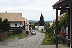
– 56; Undeclared – 3,687. Szécsény, the district seat View of Hollókő Cserhát mountains from Hollókő Castle St. Michael Church in Varsány List of cities...
5 KB (318 words) - 08:59, 30 March 2024

halfway between Vác and Balassagyarmat. Nőtincs is seated at the border of Cserhát and Börzsöny hills. Its location determines the function of the village...
3 KB (299 words) - 10:46, 30 October 2021
Galga is a right tributary of the river Zagyva in the Cserhát mountains and the Great Hungarian Plain, Hungary. It originates at Becske, Nógrád County...
1 KB (96 words) - 00:02, 27 August 2024

World Heritage Site – village Mátraverebély through the Hilly Country of Cserhát – 119 km Village Mátraverebély – peak of Galyatetö – peak of Kékestető...
25 KB (3,178 words) - 18:53, 5 July 2023

beside of the Zagyva river and the Kövicses creek, between the Mátra and Cserhát mountain ranges. As of 2022 census, it has a population of 8664 (see Demographics)...
14 KB (1,213 words) - 03:20, 2 September 2024
38417°E / 48.12083; 21.38417 (12. Nagy-Kopasz (528)) 13 Naszály 402 652 Cserhát 47°50′03″N 19°09′13″E / 47.83417°N 19.15361°E / 47.83417; 19.15361...
21 KB (312 words) - 19:26, 12 March 2022

there too. Population János Batsányi (1763–1845), poet, philosopher József Cserhát, poet, writer, editor László Marton (1925–2008), sculptor József Csermák...
9 KB (674 words) - 14:59, 12 March 2024

village is located in a narrow valley between the wooded hills of the Cserhát. In the wide valley adjacent to Kisbárkány, at the end of a dead end road...
3 KB (170 words) - 01:23, 13 July 2024

village in Nógrád County, Hungary, beside of the Zagyva river, between the Cserhát and Mátra mountain ranges. As of 2022 census, it has a population of 1790...
9 KB (662 words) - 20:24, 23 February 2024

county, from the east of Budapest to the River Galga. To the north the Cserhát, to the south and to the east the Alföld and finally to the west the River...
8 KB (588 words) - 14:30, 3 July 2023

Mátraszőlős is a village in Nógrád County, Hungary, under the Cserhát mountain ranges, beside of the Hévíz creek. As of 2022 census, it has a population...
8 KB (568 words) - 20:19, 23 February 2024
Guda The Cave of Mucin Salgó Castle The Castle Hill of Filakovo Hollókő Cserhát Mountains, north of Hollókő Lipovany panorama Global Network of National...
5 KB (606 words) - 04:42, 23 December 2022
Bajcsy-Zsilinszky. The two politicians hide together in the western part of the Cserhát hills and create their partisan company in the forest near Naszály. Due...
10 KB (1,383 words) - 06:46, 2 July 2024

village in Nógrád County, Hungary, beside of the Zagyva river, between the Cserhát and Mátra mountain ranges. As of 2022 census, it has a population of 1752...
10 KB (778 words) - 14:13, 26 February 2024

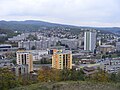
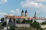
the River Ipoly at the intersection of Northern, Northeast, and Eastern Cserhát hills. The major part of the town was built on a plateau extending along...
20 KB (2,262 words) - 18:10, 16 August 2024
Füzesabony Hollókő 150 1977 Hollókő Karancs-Medves 6,619 1989 Salgótarján East Cserhát 7,425 1989 Pásztó Kesznyéten 6,084 1990 Kesznyéten Lázbérc 4,054 1975 Lázbérc...
11 KB (304 words) - 10:27, 27 February 2022