Hkakabo Razi (Burmese: ခါကာဘိုရာဇီ, pronounced [kʰàkàbò ɹàzì]; simplified Chinese: 开加博峰; traditional Chinese: 開加博峯; pinyin: Kāijiābó Fēng) is believed...
10 KB (1,184 words) - 01:34, 22 March 2024
height has been measured exactly by GPS. Hkakabo Razi has not yet been measured via GPS. However, Hkakabo Razi may still be the highest peak according...
4 KB (374 words) - 17:18, 12 February 2024
ascent of Mount Everest's north face and the first ascent of Myanmar's Hkakabo Razi. Ozaki was born in Kameyama in Japan's Mie Prefecture. On May 10, 1980...
3 KB (249 words) - 08:56, 29 March 2024
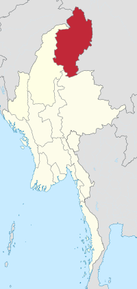
Bhamo, Mohnyin and Putao. Kachin State has Myanmar's highest mountain, Hkakabo Razi at 5,889 metres (19,321 ft), forming the southern tip of the Himalayas...
31 KB (2,987 words) - 12:34, 10 September 2024

can also be considered the 8th highest mountain in this region, after Hkakabo Razi and six others in Kachin State, Myanmar. The massive, open cut Grasberg...
18 KB (1,874 words) - 23:59, 6 September 2024

in 2012, and Cho Oyu in 2016. In 2014, Harrington attempted to climb Hkakabo Razi, the tallest peak in Southeast Asia. This peak had only been climbed...
15 KB (1,268 words) - 11:45, 22 June 2024
The Hkakabo Razi tube-nosed bat (Murina hkakaboraziensis), also known colloquially as the Lance Bass bat is a species of vesper bat in the family Vespertilionidae...
2 KB (131 words) - 17:24, 11 September 2022

Tibeto-Burman speakers known as the Taron inhabiting the remote region of Mt. Hkakabo Razi in Southeast Asia on the border of China (Yunnan and Tibet), Burma, and...
55 KB (5,652 words) - 18:16, 26 August 2024
steps, and succeeded in making the first anthropological survey of the Hkakabo Razi region. On foot they reached Tahaundam, which is inhabited by about 200...
2 KB (173 words) - 07:53, 10 August 2023
north of the Diphu Pass. The China-Myanmar border heads northeast to Hkakabo Razi just one mile west of its summit. It then turns southeast following the...
46 KB (3,406 words) - 00:03, 14 April 2024

found in the mountains surrounding Putao. Myanmar's highest mountain, Hkakabo Razi, and other snow-capped peaks are visible from Putao. Hkamti Long (also...
8 KB (441 words) - 06:00, 13 May 2024

Taunggyi Kalaw Pindaya Chaungtha Ngwesaung Myeik Archipelago Hukawng Valley Hkakabo Razi Alaungdaw Kathapa National Park Popa Mountain National Park Mount Victoria...
26 KB (1,618 words) - 16:02, 29 August 2024
system near the border with India. "Gunung Hkakabo Razi tertinggi di Asia Tenggara dan kembaran puncak Gamlang Razi". Obeng Plus. 18 January 2016. Retrieved...
865 bytes (81 words) - 06:21, 4 December 2023
Matterhorn (4,478 m) 2013: Manaslu (8,163 m) 2013: K6, North-west face 2014: Hkakabo Razi (5,881 m) 2015: Api Main (7,132 m) 2015: Denali (6,190 m) 2016: Loinbo...
18 KB (1,716 words) - 13:55, 28 August 2024
of 1,472 sq mi (3,810 km2). It was established in 1998. It surrounds Hkakabo Razi, the highest mountain in the country. It ranges in elevation from 2,950...
13 KB (1,113 words) - 04:55, 7 April 2024
first try, south west face 2014 Everest (8848m), Nepal, south side Hkakabo Razi (5881m), Myanmar, first try, north ridge 2015 Everest (8848m), China...
8 KB (736 words) - 20:18, 31 July 2024
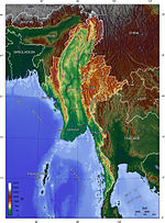
Lower Myanmar. Upper Myanmar is home to the country's highest peak, Hkakabo Razi. The region is bisected by the country's primary river, the Irrawaddy...
17 KB (1,561 words) - 08:54, 10 July 2024

northwards to Hkakaborazi National Park and the highest peak of Myanmar, Mt. Hkakabo Razi. Nogmung is also the gateway for Tahaundam, the northernmost village...
3 KB (196 words) - 18:42, 5 December 2023
British India as early as 1912, following the highest ridge from the Hkakabo Razi (alt. 5,881 m (19,295 ft); the highest point in Myanmar) at the junction...
30 KB (3,584 words) - 15:26, 5 May 2024
Location 1 Hkakabo Razi 5,881 m (19,295 ft) Myanmar 2 Gamlang Razi 5,870 m (19,259 ft) Myanmar 3 Dindaw Razi 5,464 m (17,927 ft) Myanmar 4 Tasudo Razi 5,140 m...
16 KB (54 words) - 08:16, 20 July 2024

be found in Southeast Asia. The highest mountain in Southeast Asia is Hkakabo Razi at 5,967 metres (19,577 feet) and can be found in northern Burma sharing...
183 KB (16,438 words) - 17:28, 13 September 2024
Mountain Trail, a 26-day 440 km (270 mi) trail through Mount Lebanon Hkakabo Razi Trail, climbing the highest peak in Myanmar, in Khakaborazi National...
36 KB (4,106 words) - 15:35, 2 September 2024
by snow-capped mountains, rising to the highest peak of Myanmar, Mt. Hkakabo Razi at 5880 m. Tahaundam is briefly described by the WCS. Between Tahaundam...
2 KB (155 words) - 22:43, 3 August 2023

Diphu Pass and then runs briefly north-east, across the Nanmi Pass and Hkakabo Razi (5,881 m), the highest mountain in Southeast Asia. It then turns to the...
15 KB (1,493 words) - 03:39, 9 September 2024

is located. In Myanmar, a variant of Khams Tibetan is spoken near the Hkakabo Razi, Kachin State which is adjacent to Nujiang Lisu Autonomous Prefecture...
43 KB (3,723 words) - 14:32, 29 July 2024
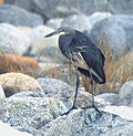
site. In northern Myanmar, it was observed along four streams in the Hkakabo Razi landscape between March 2016 and December 2020. When disturbed, the white-bellied...
16 KB (1,672 words) - 04:27, 26 August 2024
Archived from the original on 29 October 2020. Retrieved 15 April 2022. "Hkakabo Razi Landscape". UNESCO World Heritage Centre. Archived from the original...
20 KB (705 words) - 14:02, 13 January 2024

perimeter. In the north, the Hengduan Mountains form the border with China. Hkakabo Razi, located in Kachin State, at an elevation of 5,881 metres (19,295 ft)...
270 KB (23,972 words) - 02:46, 10 September 2024
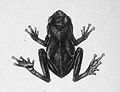
been recorded in the Nameri National Park in India and just outside the Hkakabo Razi National Park in Myanmar. This frog has been observed between 0 and 2006...
2 KB (181 words) - 04:08, 28 February 2024
(UTC+06:30) Extreme points of Myanmar High: Hkakabo Razi 5,881 m (19,295 ft) Low: Indian Ocean 0 m North: Hkakabo Razi 28°19′59″N South: Islands at Kawthaung...
17 KB (1,170 words) - 22:18, 17 August 2024