
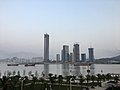
Guanabara Bay (redirect from Baía da Guanabara)
Guanabara Bay (Portuguese: baía de Guanabara, baía da Guanabara, [ɡwɐ̃nɐˈbaɾɐ]) is an oceanic bay located in Southeast Brazil in the state of Rio de Janeiro...
17 KB (1,648 words) - 14:40, 19 August 2024

Maputo Bay (redirect from Baía de Maputo)
Maputo Bay (Portuguese: Baía de Maputo), formerly also known as Delagoa Bay from Baía da Lagoa in Portuguese, is an inlet of the Indian Ocean on the coast...
13 KB (1,555 words) - 20:21, 16 June 2024

Bay of All Saints (redirect from Baía de Todos os Santos)
The Bay of All Saints (Portuguese: Baía de Todos os Santos), also known as All Saints' Bay and Todos os Santos Bay, is the principal bay of the Brazilian...
6 KB (570 words) - 02:25, 25 April 2024
Hengqin (redirect from Ilha da Montanha)
2023. Lusa (July 31, 2020). "Macau defende que Ilha da Montanha deve ser projeto pioneiro na Grande Baía". Retrieved 10 August 2023. Edmonds, Richard Louis...
13 KB (1,242 words) - 13:22, 2 June 2024

Paraty (section Chapel of Nossa Senhora da Conceição)
village of Trindade is located Tamoios Ecological Station Serra da Bocaina National Park Baia de Paraty, Paraty Mirim and Saco do Mamanguá Environmental Protection...
25 KB (2,902 words) - 00:45, 9 August 2024

a series of islands around the Bay of Paranaguá Baía da Babitonga was the site of the proposed Baía da Babitonga Wildlife Reserve, a project that was dropped...
6 KB (598 words) - 22:53, 9 March 2024

(South))) Southernmost town: Chuí, Rio Grande do Sul Easternmost point: Ilha do Sul, Ilhas de Martim Vaz, Espírito Santo (20°29′49.99272″S 28°50′51.66132″W...
8 KB (838 words) - 09:01, 12 July 2024
Manuel Lopes (writer) (redirect from O Galo Que Cantou na Baía)
Pinto Award O galo que cantou na Baía, 1959 Os Flagelados do Vento Leste, 1960, Prémio Meio Milénio do Achamento das Ilhas de Cabo Verde Poetry: Horas Vargas...
6 KB (666 words) - 23:49, 16 November 2023

The southern boundary of the freguesia is the road of Estrada da Baía de Nossa Senhora da Esperança, the reclaimed land south of the road, although commonly...
5 KB (394 words) - 16:15, 31 August 2024
Tigres Island (redirect from Ilha dos Tigres)
National Geospatial-Intelligence Agency. 2016. "Ilha dos Tigres". Mapcarta. Retrieved 10 October 2016. "Baía dos Tigres". www.redeangola.info. Retrieved 2017-09-27...
3 KB (214 words) - 17:57, 3 June 2023
Azores Rua de Aveiro – named for Aveiro, Portugal Rua da Baía Rua da Baía de Nossa Senhora da Esperança – Our Lady of Hope Bay Street Rua dos Bem Casados...
20 KB (2,689 words) - 04:26, 12 September 2024
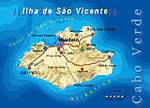
São Vicente, Cape Verde (redirect from Nossa Senhora da Luz (São Vicente))
subdivided into the following settlements: Baía das Gatas Lameirão Mindelo (city): 32 Monte Verde Norte da Baía Ribeira da Vinha Ribeira de Calhau Ribeira Julião...
24 KB (2,155 words) - 21:08, 13 June 2024

older nautical charts had identified them as the Ilhas Afortunadas ("The Fortunate Islands") or Ilhas de São Brandão ("The Islands of Saint Brendan")....
35 KB (4,750 words) - 00:23, 8 September 2024

Ilha de Santana Lighthouse (Portuguese: Farol da Ilha de Santana) is an active lighthouse on the namesake island located at the east entrance of the Baía...
3 KB (464 words) - 20:56, 12 January 2023

Horizonte to Rio de Janeiro, mysteriously crashed into the waters of Baía de Guanabara near Ilha dos Ferros on June 24, 1960. The Convair 340 was manufactured...
8 KB (882 words) - 05:47, 13 August 2024

Itaguaí (redirect from Ilha Guaiba)
contains several important iron ore loading ports of the world including Ilha Guaiba. Its population was 134,819 in 2020 and its area is 273 km2. The city...
8 KB (643 words) - 08:02, 9 August 2024

addition to swimming areas in the areas of Baía da Engrade, Baía do Céu de Abraão, Baía da Caravela and Baía da Fonte. The parishes includes several localities...
5 KB (481 words) - 14:36, 19 December 2023

Santa Maria Island (redirect from Ilha de Santa Maria)
de Geologia da Faculdade de Ciências da Universidade de Lisboa: 107. Figueiredo, Nélia Maria Coutinho (1996). As Ilhas do Infante: a Ilha de Santa Maria...
52 KB (5,755 words) - 03:04, 9 August 2024

Mosqueiro (redirect from Ilha de Mosqueiro)
the Baia de Marajó Paiva, Paulo (ed.). "A Ilha do Mosqueiro na Rota da História" [The Route of History of the Island of Mosqueiro]. Portal Ilha de Mosqueiro...
9 KB (761 words) - 16:16, 19 January 2023
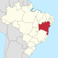
earlier captaincy of Bahia de Todos os Santos, named for Bay of All Saints (Baía de Todos os Santos in modern Portuguese), a major feature of its coastline...
81 KB (8,165 words) - 12:29, 4 September 2024

Algar do Carvão Baía de Angra do Heroísmo Baía das Pontas Baía da Salga Baía do Refugo Baía dos Salgueiros Furna de Água Galerias da Feteira Gruta do...
62 KB (6,981 words) - 13:03, 2 September 2024

Inhaca Island (Portuguese: Ilha da Inhaca), also known as Kanyaka island, is a subtropical island of Mozambique off the East African coast. The main village...
13 KB (1,383 words) - 19:59, 9 July 2024

Instituto de Estradas Ilha de Santiago, Rede rodoviária, Instituto de Estradas "Ecobus suspende rota Praia/Assomada/Praia". Expresso das Ilhas. 2016-11-07. Cape...
20 KB (1,576 words) - 16:11, 17 October 2023

[SMA11] Protected Resource Areas of Baía de São Lourenço (Portuguese: Área Protegida de Gestão de Recursos da Baía de São Lourenço) [SMA12] Protected Resource...
7 KB (608 words) - 14:46, 3 June 2021

traders established an Inhaca Island base to ply the Bay of the Lagoon's (Baía da Lagoa) rivers in search of ivory. A 1747 map by Emanuel Bowen records 'Inhaqua'...
7 KB (497 words) - 15:54, 11 June 2024

An account of the Castilian invasion of Terceira in 1611 identified the Baía das Mós, the island's subsequent occupation and the existence of a community...
12 KB (1,382 words) - 19:47, 11 March 2023

Portugal: Tribuna das Ilhas, retrieved 5 September 2011 Nóe, Paulo (2002). "Bombardeira/Fortificação do Século XVII na baía do Porto Pim (IPA...
34 KB (4,169 words) - 14:48, 4 February 2024

original on 21 December 2007. Retrieved 26 October 2008. "Contexto ambiental da Baía de Sepetiba" (in Portuguese). Observatório Quilombola (OQ). 2001. Archived...
230 KB (20,496 words) - 12:50, 14 September 2024

Station Taipa Ferry Terminal Ilha Verde (former island) Area between Lago Nam Van and Lago Sai Van on Baía da Praia Grande Aterro da "Zona A" dos Novos Aterros...
6 KB (598 words) - 11:36, 13 September 2024

The island's fortress named Fortaleza de Santo António da Ponta da Mina on a point inside Baía de Santo António (Santo António Bay) was built in 1695...
12 KB (978 words) - 00:51, 9 August 2024