
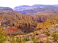
The Mogollon Rim (/mʌɡɪˈjoʊn/ or /moʊɡəˈjoʊn/ or /mɒɡɒdʒɔːn/) is a topographical and geological feature cutting across the northern half of the U.S. state...
7 KB (807 words) - 20:14, 12 December 2023

Mogollon culture (/ˌmoʊɡəˈjoʊn/) is an archaeological culture of Native American peoples from Southern New Mexico and Arizona, Northern Sonora and Chihuahua...
23 KB (2,654 words) - 14:52, 15 May 2024

Bigfoot, reported to dwell in central and eastern Arizona along the Mogollon Rim. The Mogollon Monster is commonly described as a large bipedal creature, over...
10 KB (1,138 words) - 06:28, 10 February 2024
List of lakes of Arizona (redirect from List of lakes and reservoirs – Mogollon Rim – Mogollon Plateau)
This is a list of notable lakes and reservoirs located in the U.S. state of Arizona. Many of the lakes listed here contain game fish and are managed by...
7 KB (502 words) - 21:59, 20 February 2024

Payson, Arizona (category Populated places of the Mogollon Rim)
the White Mountain Apache Tribe—took place just north of town on the Mogollon Rim. The battle occurred within the greater context of the Apache Wars. On...
31 KB (2,694 words) - 18:46, 14 August 2024
plateau is the Mogollon Rim. The Mogollon Plateau is 7,000–8,000 feet (2,100–2,400 m) high. The plateau lends its name to the Mogollon tribe, part of...
3 KB (370 words) - 19:26, 20 December 2021

Willow Springs Lake is a cold water lake located on top of the Mogollon Rim in northern Arizona, about 23 mi (37 km) east of the city of Payson in the...
7 KB (602 words) - 15:44, 6 March 2024

Coconino National Forest (category Mogollon Rim)
temperatures year round. The Third district is the Mogollon Rim District, located along the Mogollon Rim south of the Mormon Lake District and east of the...
18 KB (2,006 words) - 22:24, 30 May 2024

Heber-Overgaard, Arizona (category Populated places of the Mogollon Rim)
place (CDP) in Navajo County, Arizona, United States. Situated atop the Mogollon Rim, the community lies at an elevation of 6,627 feet (2,020 m). The population...
54 KB (5,516 words) - 17:41, 22 July 2024

Pinetop-Lakeside, Arizona (category Populated places of the Mogollon Rim)
Pinetop–Lakeside is a town in Navajo County, Arizona, United States. According to 2020 census, the population of the town is 4,557. It was founded in 1984...
12 KB (582 words) - 22:40, 8 July 2024
along the Mogollon Rim Mogollón, Los Santos, Panama Mogollon Baldy, one of the tallest peaks in the Mogollon Mountains in New Mexico Mogollon Mountains...
1 KB (184 words) - 09:44, 18 June 2021
southern Colorado Plateau (Mogollon Plateau) it has an average elevation of 4,000–5,000 feet. Physiographic Features Mogollon Rim San Francisco Volcanic Field...
2 KB (248 words) - 14:40, 19 May 2024

Blue Ridge Reservoir is located in the Mogollon Rim area of the state of Arizona. Clints Well, Arizona. Blue Ridge Reservoir is one of the more scenic...
2 KB (97 words) - 03:15, 10 November 2022
Tonto National Forest (category Mogollon Rim)
Desert to 7,400 feet (2,256 m) in the ponderosa pine forests of the Mogollon Rim (pronounced MOH-gee-on, or MUH-gee-own). The Tonto National Forest is...
9 KB (761 words) - 19:37, 19 May 2024

area. Bordering southwest and south is the Mogollon Plateau, and on the plateau's south border the Mogollon Rim, the north border of the Arizona transition...
14 KB (862 words) - 21:20, 3 November 2023

Salt River (Arizona) (category Rivers of the Mogollon Rim)
other tributaries of the upper Salt River, drain the region between the Mogollon Rim in the north and the Natanes Mountains and Natanes Plateau to the east...
19 KB (2,023 words) - 21:39, 14 February 2024

Strawberry, Arizona (category Populated places of the Mogollon Rim)
the north by Coconino County. The county line follows the edge of the Mogollon Rim. Arizona State Route 87 passes through Strawberry. It is a two-hour drive—108...
8 KB (654 words) - 17:50, 19 April 2024

Pine, Arizona (category Populated places of the Mogollon Rim)
vacation and retirement centers in north-central Arizona, below the Mogollon Rim. Pine's elevation is 5,448 feet (1,661 m), and the Pine post office was...
8 KB (667 words) - 22:51, 14 May 2024

inches (760 mm) of precipitation annually, and the southern slopes of the Mogollon Rim and the southeast average between 15 and 20 inches (380 and 510 mm)....
25 KB (3,808 words) - 17:58, 6 January 2024

it occurs south and southwest of the Arizona transition zone of the Mogollon Rim; in the northwest-central Sonoran Desert of Arizona, it is in a few selected...
7 KB (767 words) - 11:41, 14 August 2024

Show Low, Arizona (category Populated places of the Mogollon Rim)
Show Low is a city in Navajo County, Arizona. It lies on the Mogollon Rim in east central Arizona, at an elevation of 6,345 feet (1,934 m). The city was...
19 KB (1,347 words) - 22:36, 8 July 2024

Tonto Basin (category Mogollon Rim)
Creek and its tributaries in central Arizona, at the southwest of the Mogollon Rim, the higher elevation transition zone across central and eastern Arizona...
3 KB (295 words) - 09:11, 5 April 2022

Zane Grey also had a cabin under the Mogollon Rim near Payson, Arizona. There is a replica of that cabin at the Rim Country Museum. Zane Grey Estate, NRHP-listed...
3 KB (196 words) - 05:48, 9 August 2023

area around San Francisco Mountain, and significant portions of the Mogollon Rim country, between approximately 500 and 1425 CE. Since fully developed...
10 KB (992 words) - 15:09, 31 December 2023

surpassing the Rodeo-Chediski Fire which burned 468,638 acres along the Mogollon Rim in 2002.[citation needed] Greer sits at 8,356 feet in elevation and is...
27 KB (2,228 words) - 10:31, 21 June 2024

lakes located on the Mogollon Rim, collectively referred to as the Rim Lakes. It is among the more developed and accessible of the Rim Lakes. It is also...
6 KB (393 words) - 16:50, 24 September 2023
Southern Nevada, and in Arizona through the transition zone to the eastern Mogollon Rim, where it grows in canyons, mountain slopes, washes, and other dry habitats...
5 KB (546 words) - 12:22, 30 June 2024

greater Phoenix area. The valley is overlooked by Mingus Mountain and the Mogollon Rim. The valley is one of three regions of viticulture in Arizona and contains...
3 KB (264 words) - 13:47, 19 August 2023

Nevada, Utah, Idaho, the western third of Montana, Arizona north of the Mogollon Rim, Colorado from the Front Range westward, New Mexico from the central...
8 KB (708 words) - 06:39, 14 August 2024
Hellsgate Wilderness (category Mogollon Rim)
the Tonto National Forest in Gila County, Arizona, at the base of the Mogollon Rim. It was created by the U.S. Congress in 1984 and is managed by the U...
5 KB (470 words) - 11:59, 15 June 2024