town in Nagaon district Nelly Island, Antarctica Nelly Island, Bermuda Mount Nelly, Bolivia, a stratovolcano in the Andes Nelly (given name), a list of...
2 KB (233 words) - 15:06, 1 July 2024
Nelly Island is the largest and easternmost of the Frazier Islands, lying in Vincennes Bay off Wilkes Land, East Antarctica. The Frazier Islands were delineated...
2 KB (165 words) - 22:38, 11 July 2024

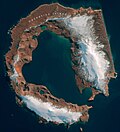
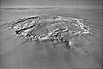
Isle) is one of the smaller of the South Shetland Islands of Antarctica. Penguin Island was sighted in January 1820 by a British expedition under Edward...
6 KB (475 words) - 16:59, 6 April 2024
Antarctic and sub-Antarctic islands. Antarctic islands are, in the strict sense, the islands around mainland Antarctica, situated on the Antarctic Plate...
74 KB (12,543 words) - 10:20, 25 June 2024

Cape Evans (redirect from Inaccessible Island (Antarctica))
633; 166.400 (Cape Evans)) is a rocky cape on the west side of Ross Island, Antarctica, forming the north side of the entrance to Erebus Bay. The cape was...
7 KB (1,027 words) - 15:39, 14 February 2024
Deception Island (Antarctica) – via researchgate.net. "Deception Island". Global Volcanism Program. Smithsonian Institution. Portals: Geography Islands Engineering...
39 KB (4,027 words) - 16:32, 22 September 2024
The Danger Islands (63°25′S 54°40′W / 63.417°S 54.667°W / -63.417; -54.667 (Danger Islands)) are a group of islands lying 13 nautical miles (24 km;...
7 KB (871 words) - 18:16, 14 July 2024

The geography of Antarctica is dominated by its south polar location and, thus, by ice. The Antarctic continent, located in the Earth's southern hemisphere...
23 KB (2,657 words) - 13:38, 19 September 2024
Mount Takahe (category Calderas of Antarctica)
460-metre-high (11,350 ft) snow-covered shield volcano in Marie Byrd Land, Antarctica, 200 kilometres (120 mi) from the Amundsen Sea. It is a c. 30-kilometre-wide...
53 KB (5,483 words) - 10:04, 17 July 2024

Island, in the South Shetland Islands of Antarctica. It is a small, unnamed headland, some 2.5 km east of Nelly Point, which has been referred to unofficially...
1 KB (128 words) - 03:27, 10 June 2022
the Breidnes Peninsula, Vestfold Hills, Princess Elizabeth Land, Antarctica. The island was mapped by Norwegian cartographers from aerial photos taken by...
3 KB (194 words) - 16:03, 21 August 2021
south-west coast of Anvers Island in Wylie Bay, in the Palmer Archipelago of Antarctica. It was surveyed by the British Naval Hydrographic Survey Unit in 1956-1957...
4 KB (295 words) - 03:37, 27 July 2024

Cape Royds (redirect from Blue Lake (Antarctica))
dark rock cape forming the western extremity of Ross Island, facing on McMurdo Sound, Antarctica. It was discovered by the British National Antarctic...
12 KB (1,875 words) - 13:08, 29 March 2024

Heywood Island is the largest of the islands off the north coast of Robert Island in the South Shetland Islands, Antarctica. It is named after Captain...
4 KB (314 words) - 02:26, 29 April 2022

Cockburn Island is an oval island 2.7 kilometres (1.7 mi) long, consisting of a high plateau with steep slopes surmounted on the northwest side by a pyramidal...
6 KB (541 words) - 01:45, 26 August 2023

Peninsula, Vestfold Hills, in Prydz Bay, Princess Elizabeth Land, Antarctica. The island was mapped by Norwegian cartographers from aerial photos taken by...
3 KB (192 words) - 16:08, 21 August 2021
Cameron Island is a small island just north of Hailstorm Island, in the Swain Islands, Antarctica. This region was photographed from the air by U.S. Navy...
2 KB (173 words) - 20:25, 29 January 2022

2018. "Snow Hill Island". BirdLife data zone: Important Bird Areas. BirdLife International. 2013. Retrieved 19 January 2013. Antarctica. Sydney: Reader's...
10 KB (1,280 words) - 16:38, 12 April 2024
3 km; 5.8 mi) south-east of Cape McCormick, in Victoria Land, Antarctica. The Possession Islands were named by Captain James Clark Ross, Royal Navy, in commemoration...
7 KB (999 words) - 18:30, 23 January 2024

mile (1.9 km; 1.2 mi) southwest of Hovgaard Island in the Wilhelm Archipelago, Antarctica. Petermann Island is off the Graham Coast of the Antarctic Peninsula...
14 KB (1,941 words) - 23:44, 11 August 2024

Gregory Island is a small ice-free island lying just off the east coast of Victoria Land, Antarctica, 5 km (3.1 mi) north-east of Cape Archer and 8 km...
3 KB (221 words) - 19:12, 14 February 2024
Hughes Bay, off the west coast of Graham Land, Antarctica. Murray Island is also known as Bluff Island. It lies at the southwest end of Hughes Bay, on...
5 KB (556 words) - 15:26, 26 May 2024
Charlton Island is the westernmost of the Frazier Islands, lying in Vincennes Bay off Wilkes Land in East Antarctica. The island was mapped from air photographs...
2 KB (150 words) - 22:35, 11 July 2024

north coast. Berkner Island is about 150 km (93 mi) west of Luitpold Coast, Coats Land, the closest mainland of Eastern Antarctica. The Hemmen Ice Rise...
8 KB (780 words) - 17:26, 29 July 2024

The Frazier Islands are a group of three rocky islands - Nelly, Dewart and Charlton - in the eastern part of Vincennes Bay, East Antarctica, 15 km (9 mi)...
3 KB (214 words) - 23:36, 3 July 2021

Mount Terra Nova (category Shield volcanoes of Antarctica)
990 ft) high, between Mount Erebus and Mount Terror volcanoes on Ross Island in Antarctica. It was first mapped by the British National Antarctic Expedition...
6 KB (830 words) - 14:19, 19 July 2024

List of Antarctic islands south of 60° S Livingston Island Saddleback Ridge SCAR Territorial claims in Antarctica "Half Moon Island". BirdLife data zone:...
10 KB (976 words) - 04:52, 26 August 2024

Waterhouse Island is an island in Prydz Bay on the Ingrid Christensen Coast of Princess Elizabeth Land, Antarctica. It lies just SSW of Lugg Island, and about...
2 KB (150 words) - 14:13, 12 June 2022
Sabrina Island is the largest of three small islets lying 1.5 km (0.93 mi) south of Buckle Island in the Balleny Islands of Antarctica and are part of...
3 KB (205 words) - 06:12, 12 November 2023

Signy Island is a small subantarctic island in the South Orkney Islands of Antarctica. It was named by the Norwegian whaler Petter Sørlle (1884–1933)...
21 KB (2,830 words) - 21:59, 1 December 2023