
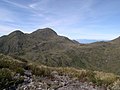
Pico da Bandeira, or Bandeira Peak (Portuguese for Flag Peak, pronounced [ˈpiku dɐ bɐ̃ˈdejɾɐ]), is the third highest mountain in Brazil, situated on the...
3 KB (315 words) - 13:13, 10 November 2023

Pico da Neblina (Portuguese pronunciation: [ˈpiku dɐ neˈblĩnɐ], Mist Peak) is the highest peak in Brazil, 2,995.3 metres (9,827 ft) above sea level, in...
16 KB (1,939 words) - 18:16, 12 February 2024
municipality Bandeira do Sul, Minas Gerais, Brazil Bandeira River (Chopim River tributary), Brazil Bandeira River (Piquiri River tributary), Brazil Pico da Bandeira...
605 bytes (102 words) - 15:27, 13 April 2022

Agulhas Negras Peak (redirect from Pico das Agulhas Negras)
mountains are Pico da Neblina 2,995 metres (9,826 ft), Pico 31 de Março 2,974 metres (9,757 ft), Pico da Bandeira 2,891 metres (9,485 ft), and Pedra da Mina 2...
11 KB (959 words) - 16:03, 13 November 2023

apex of Borneo. 20. Mount Elbrus is the highest peak of Europe. 21. Pico da Bandeira is the third highest peak of Brazil. 22. Mount Cameroon is the highest...
13 KB (728 words) - 16:34, 23 June 2024

is the location for the entrance to Caparaó National Park and the Pico da Bandeira from Espirito Santo. IBGE - "Archived copy". Archived from the original...
3 KB (104 words) - 04:41, 16 April 2024

neighbors São Paulo and Rio de Janeiro. The most notable one is the Pico da Bandeira, the third highest mountain in Brazil at 2890 m, standing on the border...
42 KB (4,467 words) - 00:40, 2 July 2024

the border between Minas Gerais and Espírito Santo states in Brazil. Pico da Bandeira, one of the highest mountains in Brazil, is located there. The park...
7 KB (635 words) - 23:59, 9 November 2022
Mar Serra Geral The highest point of the Brazilian Highlands is the Pico da Bandeira in the Serra do Caparaó, 2,891 meters (9,485 ft). Guiana Shield Serras...
5 KB (391 words) - 18:24, 30 May 2024

Jânio Quadros. It contains the third highest peak in the country, the Pico da Bandeira (2,891 m). In 1859 Emperor Dom Pedro II had ordered that a flag of...
6 KB (499 words) - 13:16, 24 July 2023
Geography and Statistics (IBGE) and the Military Institute of Engineering (IME). Pico do Cruzeiro is not officially defined as a "mountain" by IBGE because of...
4 KB (83 words) - 11:40, 7 July 2024
from South America. It is endemic to Brazil where it is found in the Pico da Bandeira mountain range. The Caparaó hocicudo grows to a head-and-body length...
3 KB (367 words) - 13:33, 5 December 2023

Pico Island (Ilha do Pico, Portuguese pronunciation: [ˈiʎɐ ðu ˈpiku]) is an island in the Central Group of the Portuguese Azores. The landscape features...
44 KB (4,409 words) - 04:33, 31 October 2023
shrubs). Pico da Bandeira (2892 m) is the highest point in the region. Other peaks also worth mentioning are: Pico do Calçado ("Shoe Peak", 2849 m), Pico do...
2 KB (237 words) - 06:18, 16 March 2023

Capitólio, Camanducaia, Caparaó National Park, Pico da Bandeira, Serra do Cipó National Park, Serra da Canastra National Park; São Paulo: São Paulo, São...
45 KB (3,075 words) - 08:46, 15 July 2024
mountains are Pico da Neblina (2,995 m/9,826 ft), Pico 31 de Março (2,974 m/9,757 ft), and Pico da Bandeira (2,891 m/9,485 ft). However, Pedra da Mina becomes...
24 KB (2,837 words) - 07:28, 19 March 2023

highland area known as Serra (where one can find the 2,890 meter tall Pico da Bandeira), which is part of the larger Serra do Caparaó range. According to...
47 KB (4,753 words) - 12:12, 20 June 2024
highest point, including Distrito Federal. The highest point in Brazil is Pico da Neblina, in Amazonas, at 2,994 metres (9,822 feet), which ranks the country...
6 KB (150 words) - 17:40, 9 April 2024

Fort of Ponta da Bandeira (Forte da Ponta da Bandeira), also known as Pau da Bandeira Fort (Flag's Mast Fort); Fort of Nossa Senhora da Penha de França...
7 KB (995 words) - 16:57, 5 December 2022

da Ajuda da Bretanha, Edital 1087/2008: Ordenação Heráldica Brasão, Bandeira e Selo (PDF) (in Portuguese), vol. Série II, Lisbon, Portugal: Diário da...
12 KB (1,354 words) - 04:23, 15 April 2024
metres (4,921 ft) or more. "Novas medições definem altitude das montanhas mais altas da Serra do Mar". 31 October 2014. Lists - South America Map - North...
19 KB (52 words) - 22:17, 6 December 2023
McLoughlin, Oregon, US Pic de Sanfonts 2,894 9,495 Pyrenees, Andorra Pico da Bandeira 2,892 9,488 Serra do Caparaó, Minas Gerais/Espírito Santo, Brazil Collarada...
138 KB (176 words) - 13:40, 17 July 2024

of Bandeiras and Santa Luzia on the northern coast of the island, located along the regional E.R.1-1ª roadway between Madalena and São Roque do Pico. Managed...
6 KB (555 words) - 03:54, 2 July 2023

Labardas, Nogueira, Pico da Madeira, Pico da Varanda, Pico do Bode, Pico do Refugio, Rebentão, Santana, São Sebastião, Senhora da Conceição and Tulha...
12 KB (1,399 words) - 07:26, 15 December 2023

Nationalist Movement (Brazil) "Adiado julgament odos guerrilheiros". Correio da Manhã, Ano LXVI, edição 22712, página 8. 21 April 1967. Retrieved 10 February...
8 KB (688 words) - 22:45, 19 May 2024

Bandeiras (Portuguese for 'Flags') is a civil parish in the municipality of Madalena on the island of Pico in the Azores. The population in 2011 was 626...
5 KB (500 words) - 12:15, 26 August 2023
area is 152 km². Settled in the highplanes among offshoots from the Pico da Bandeira, the third highest mountain of Brazil nearing 3,000 meters, in the...
3 KB (111 words) - 12:08, 27 November 2021

Povoamento e organização da territorio (in Portuguese), Lajes do Pico (Azores), Portugal: Câmara Municipal de Lajes do Pico, retrieved 27 December 2016...
8 KB (780 words) - 11:05, 1 November 2023

Roque do Pico in the Azores. The population in 2011 was 422, in an area of 30.13 km2. It is the northernmost parish on the island. The Pico Airport is...
3 KB (145 words) - 07:03, 21 September 2022

Monument to the Bandeiras is a large-scale granite sculpture by the Italian-Brazilian sculptor Victor Brecheret (1894-1955) at the entrance of Ibirapuera...
5 KB (327 words) - 19:29, 27 July 2022