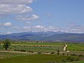
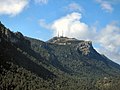
ridge's highest summit, Pico Urbión, is 2,228 m) is one of the highest points in the 500 km long Sistema Ibérico. The Picos de Urbión are located in the municipal...
3 KB (200 words) - 15:49, 12 July 2024

become planks, and are sold to Spain and other countries. Pico de Urbión (lit. Tip of Urbión): observed from the valley, much touristic interest. Castroviejo:...
6 KB (350 words) - 16:55, 20 March 2023
Ibérico Sierra de la Demanda Picos de Urbión Sierra de Albarracín Serranía de Cuenca Sierra Morena Sierra Madrona Sierra de Aracena Sierra de Hornachuelos...
61 KB (7,461 words) - 15:29, 6 August 2024

as the Negra de Urbión Lake, in the Picos de Urbión, the Grande de Gredos Lake, in Gredos, the Sanabria Lake, in Zamora or the La Nava de Fuentes Lake...
112 KB (10,808 words) - 17:47, 18 August 2024

largest river of the Iberian Peninsula by discharge. It rises near Duruelo de la Sierra in the Spanish province of Soria, meanders briefly south, then flows...
19 KB (1,750 words) - 18:27, 17 August 2024
La Rioja (redirect from Boletín Oficial de la Rioja)
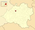
province. Other mountains include Sierra de Camero Viejo, Sierra de Camero Nuevo, Sierra de Cebollera, and Picos de Urbión. The Ebro is the main river passing...
32 KB (3,257 words) - 08:55, 15 August 2024

de la Demanda, Sierra de Neila, Mesa de Cebollera and the Picos de Urbión in the northwest, the Sierra de Alcarama, Sierra de Peñalmonte, Sierra de Moncalvillo...
21 KB (2,047 words) - 09:02, 15 August 2024

subregion of High Najerilla. Through Viniegra passes the Urbión river, which born in the Picos de Urbión, which are within the municipal term of the population...
10 KB (918 words) - 20:32, 17 August 2024

Sierra de la Demanda. The Picos de Urbión are located south of this range. Valdezcaray Sierra de la Demanda (comarca), Geography of Spain Montes de Oca,...
3 KB (190 words) - 01:55, 30 June 2024

fossils that have been recovered from the formation. The Urbión Group, named after the Picos de Urbión, comprises a sequence of brown limestones in a matrix...
12 KB (1,163 words) - 04:43, 22 July 2024

Roques de Benet is a compact group of sheer rocky outcrops in the northwestern side of the Ports de Tortosa-Beseit, Catalonia, Spain. The highest summit...
2 KB (96 words) - 21:24, 1 July 2024
census (INE), the municipality had a population of 1,924 inhabitants. Picos de Urbión Municipal Register of Spain 2018. National Statistics Institute. Covaleda...
2 KB (77 words) - 00:31, 19 August 2024
2 Expert. 2 restaurants. 1 skiing school. 1 ski hiring store. Picos de Urbión http://www.valdezcaray.es - Official resort site. 42°15′N 2°58′W /...
2 KB (193 words) - 07:25, 9 May 2023
Mont Caro (redirect from Serra de Caro)
pronunciation: [ˈmoŋ ˈkaɾu]) or Caro is the highest mountain of the Ports de Tortosa-Beseit, Catalonia, Spain. It has an elevation of 1,441 metres above...
1 KB (72 words) - 22:46, 2 August 2024
Real Soriana Occidental crosses the municipality from North to South. Picos de Urbión Municipal Register of Spain 2018. National Statistics Institute. "Abejar"...
5 KB (300 words) - 01:27, 23 May 2022
Gómez-Moliner, B.J. (2020). "An unexpected new Oestophora species from Picos de Urbión, Iberian Peninsula (Pulmonata:Trissexodontidae)". Iberus. 38 (1): 135–149...
86 KB (7,198 words) - 20:44, 13 June 2024

Cuadro sinóptico de los sistemas montañosos españoles, .xls table on www.ine.es "La tecnología destrona al Pico de las Nieves como techo de la isla". Media...
56 KB (90 words) - 15:33, 6 August 2024

Burgos (redirect from Museo de Burgos)
The municipality has a population of about 180,000 inhabitants. The Camino de Santiago runs through Burgos. Founded in 884 by the second Count of Castile...
47 KB (5,053 words) - 11:49, 17 August 2024

ES0000003 Picos de Europa (official name: Picos de Europa) Other names: n/a 43°09′09″N 4°57′19″W / 43.1526°N 4.9553°W / 43.1526; -4.9553 (Picos de Europa)...
25 KB (49 words) - 10:29, 20 December 2022
Embalse de las Cañas 101 250 Embalse de Orellana 5,500 14,000 Embalses de Cordobilla y Malpasillo 1,972 4,870 Humedales de la Sierra de Urbión 86 210 Humedales...
242 KB (220 words) - 03:54, 22 August 2024

group being thickest in the Central Coal Basin Unit. Further east in the Picos de Europa it remained covered in shallow water with continuous formation of...
98 KB (12,159 words) - 17:44, 13 August 2024
Urbasa Formation Paleogene Urbión Group/Larriba Formation Cretaceous Urbión Group/Leza Formation Cretaceous Urbión Group/Pinilla de los Moros Formation Cretaceous...
18 KB (23 words) - 18:20, 20 February 2023

Spain 2018. National Statistics Institute. Asociación Cultural Valle Del Rio Pico (in Spanish) 42°21′36″N 3°33′28″W / 42.36000°N 3.55778°W / 42.36000; -3...
2 KB (66 words) - 20:59, 22 August 2024