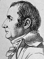
Pierre Jacotin (1765–1827) was the director of the survey for the Carte de l'Égypte (Description de l'Égypte), the first triangulation-based map of Egypt...
3 KB (231 words) - 05:11, 23 April 2024
Giaches de Wert (1535–1596), Franco-Flemish composer active in Italy Pierre Jacotin (1765–1827), French map-maker for Napoleon This disambiguation page...
830 bytes (154 words) - 21:10, 18 January 2018

dates to 1798 during Napoleon Bonaparte's expedition to Egypt. Engineer Pierre Jacotin drew up a map of the site in the Description de l'Égypte. It was first...
21 KB (2,272 words) - 14:51, 26 August 2024

their community in 1909–1910. A map from Napoleon's invasion of 1799 by Pierre Jacotin showed the place as ruined. Umm Junieh was just by the ancient bridge...
15 KB (1,478 words) - 16:04, 10 August 2024
to be cultivated by neighbouring villages. Beit Hanoun survived, and Pierre Jacotin named the village Deir Naroun on his map depicting Napoleon's Syrian...
29 KB (2,523 words) - 09:53, 24 August 2024
associated with the Cairo Citadel to guard the fortress at Khan Yunis. Pierre Jacotin named the village Kan Jounes on his map from 1799, while in 1838, Robinson...
30 KB (2,802 words) - 02:08, 31 August 2024

area; a total of 20,000 akçe. A map from Napoleon's invasion of 1799 by Pierre Jacotin named it Qarihagi, (Quryet Jitt) as a village by the road from Jaffa...
21 KB (1,794 words) - 16:48, 2 September 2024

October 2023. "Carte geographique de l'Egypte et des pays environnans by Pierre Jacotin". PAThs – Archaeological Atlas of Coptic Literature. 1818. "Nag Hammadi...
8 KB (446 words) - 02:38, 3 May 2024

French campaign in Egypt and Syria in 1799, it was noted on the map that Pierre Jacotin compiled that year as 'Ebneh'. An American missionary, William Thomson...
39 KB (3,607 words) - 17:26, 8 July 2024

mentioned under the name of Afel by Marino Sanuto the Elder. A map by Pierre Jacotin from Napoleon's invasion of 1799 showed this place, named as Afouleh...
39 KB (3,430 words) - 18:59, 21 August 2024

inhabitants. Annual tax revenue from the town amounted to 17,300 akces. Pierre Jacotin named the village Deir K Helleh on his map from 1799. In 1838, Deir...
65 KB (6,632 words) - 10:27, 17 August 2024
biblical Magdala. The village appeared as El Megdel on the 1799 map of Pierre Jacotin. In the early 19th century, foreign travellers interested in the Christian...
51 KB (5,335 words) - 04:02, 18 July 2024

Sultan. The village appeared as Lydda, though misplaced, on the map of Pierre Jacotin compiled in 1799. Missionary William M. Thomson visited Lydda in the...
59 KB (6,313 words) - 07:17, 28 August 2024

government. In 1799, it appeared as the village Atlit on the map that Pierre Jacotin compiled that year. During the rule of Acre governor Sulayman Pasha...
15 KB (1,657 words) - 21:43, 23 January 2024

The village appeared under the name of Koufour Tai on the map that Pierre Jacotin compiled during Napoleon's invasion of 1799, while in 1856 it was named...
24 KB (2,150 words) - 05:35, 1 September 2024

for "the harbour"), was located in the area. In the late Ottoman era, Pierre Jacotin named the place Majumas on his map from 1799. In 1883, the PEF's Survey...
11 KB (1,066 words) - 09:52, 14 July 2024
beehives, and a press for olives or grapes; a total of 11,342 akçe. Pierre Jacotin called the village Qalensawi on his map from 1799. In 1870, the French...
22 KB (1,864 words) - 15:41, 24 March 2024
of the revenue went to the waqf of al-Haramayn as-Sarifayn. In 1799, Pierre Jacotin misplaced Atil instead of Baka, on his map made during the French campaign...
24 KB (2,302 words) - 04:55, 22 June 2024

Bonaparte described al-Bassa as a village of 600 Metawalis. A map by Pierre Jacotin from Napoleon's invasion of that year showed the place, named as El...
40 KB (4,176 words) - 22:37, 16 July 2024

'Ali bin 'Ulaym. It appeared, just named "village" on the map that Pierre Jacotin compiled during Napoleon's invasion of 1799. Sozusa in Palaestina is...
25 KB (2,822 words) - 08:18, 13 July 2024

of Egypt, Syria and Palestine. The mapmaking expedition was led by Pierre Jacotin. It was used as the basis for many most maps of the region for much...
5 KB (352 words) - 04:10, 27 May 2023

and goats; a total of 19,800 akçe. All of the revenue went to a waqf. Pierre Jacotin called the village Taibeh on his map in 1799. In the 1860s, the Ottoman...
19 KB (1,839 words) - 18:51, 10 August 2024

as his headquarters. The village appeared as 'Ramleh' on the map of Pierre Jacotin compiled during this campaign. In 1838, Edward Robinson found Ramleh...
61 KB (6,805 words) - 06:11, 1 September 2024

Tabariyya of the Liwa of Safad, with its land designated as timar. A map by Pierre Jacotin from Napoleon's invasion of 1799 noted the place. In 1875, Victor Guérin...
20 KB (1,688 words) - 14:18, 8 March 2024

villages when he pardoned him. A map from Napoleon's invasion of 1799 by Pierre Jacotin showed the place, named as Hattin. Johann Ludwig Burckhardt, a Swiss...
32 KB (3,071 words) - 02:02, 13 April 2024

hill overlooking Saffuriya. A map from Napoleon's invasion of 1799 by Pierre Jacotin showed the place, named as Safoureh. In the early 19th century, the...
66 KB (6,642 words) - 09:52, 2 September 2024

century, it was resettled by Bani Sa'b tribesmen from Hajjah and Baqa. Pierre Jacotin called the village "Ertahah" on his map from 1799, possibly mixing it...
36 KB (3,993 words) - 00:09, 26 August 2024

Latin sources. The name was later transformed into Caymont. In 1799, Pierre Jacotin labeled the site Chateau d'El Kireh (Castle of Qira). The castle mentioned...
60 KB (7,441 words) - 18:52, 27 August 2024

Multiplication at Tabgha. A map from Napoleon's invasion of 1799 by Pierre Jacotin showed Tabgha, marked by the word Moulin (mill in French). The 4th-century...
24 KB (2,366 words) - 20:35, 9 June 2024
Kingdom William Faden (England, 1749–1836), successor to Thomas Jefferys Pierre Jacotin (France, 1765–1829) Murdoch McKenzie (Scotland, died 1797) John Mitchell...
30 KB (3,143 words) - 00:15, 29 August 2024