
Pittsburg is a town in Coös County, New Hampshire, United States. The population was 800 at the 2020 census. It is the northernmost town in New Hampshire...
20 KB (1,510 words) - 12:26, 17 September 2024

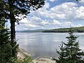
Connecticut Lakes (redirect from Connecticut Lakes, New Hampshire)
along the Connecticut River in northern New Hampshire. First Connecticut Lake is located in the town of Pittsburg, 7 miles (11 km) northeast of the village...
19 KB (1,221 words) - 23:57, 9 April 2024
Florida Pittsburg, Kansas, Crawford County Pittsburg, New Hampshire Pittsburg, Oklahoma Pittsburg, Texas Pittsburg County, Oklahoma Pittsburg Township...
2 KB (268 words) - 22:09, 19 May 2023

Republic of Indian Stream (category Pittsburg, New Hampshire)
of Pittsburg in 1840. In 1842, the land dispute was definitively resolved by the Webster–Ashburton Treaty, and the land was assigned to New Hampshire. The...
14 KB (1,512 words) - 22:15, 30 September 2024
Indian Stream (category Pittsburg, New Hampshire)
1 miles (30.7 km) long, in New Hampshire in the United States. It rises in the mountains of extreme northern New Hampshire, in Coos County near the Canada–United...
3 KB (159 words) - 01:25, 13 July 2022
Luther Parker (category People from Coös County, New Hampshire)
in what is now Pittsburg, New Hampshire. He later was an early settler in present-day Muskego, Wisconsin. Born in Temple, New Hampshire, Parker was a shoemaker...
7 KB (452 words) - 19:33, 9 April 2024

Minik Wallace (category Pittsburg, New Hampshire)
29 October 1918. He was buried in the Indian Stream Cemetery in Pittsburg, New Hampshire. In 1986, Kenn Harper wrote a book about Minik, entitled Give Me...
13 KB (1,681 words) - 17:50, 15 July 2024

The Pittsburg–Chartierville Border Crossing connects the towns of Chartierville, Quebec, and Pittsburg, New Hampshire. The crossing can be reached by...
11 KB (1,097 words) - 23:21, 22 June 2024
Lake Francis (Murphy Dam) (redirect from Lake Francis (New Hampshire))
Connecticut River in northern New Hampshire, United States. The lake is located in Coos County, east of the village of Pittsburg and along the boundary between...
5 KB (385 words) - 14:44, 31 December 2022

New Hampshire is the state with the seventh highest median household income in the United States: $89,992 as of 2022. The most affluent parts of the state...
14 KB (153 words) - 13:23, 12 April 2024

New Hampshire is a state located in the Northeastern United States. It is divided into 234 municipalities, including 221 towns and 13 cities. New Hampshire...
61 KB (524 words) - 12:29, 22 August 2024

Mount Magalloway (category Pittsburg, New Hampshire)
region of New Hampshire in the United States. With a summit elevation of 3,383 feet (1,031 m), it is one of the tallest peaks in Pittsburg, the state's...
2 KB (166 words) - 21:31, 25 July 2024
Pittsburg, Kansas Pittsburg High School (New Hampshire), Pittsburg, New Hampshire Pittsburg High School (Oklahoma), Pittsburg, Oklahoma Pittsburg High School...
430 bytes (85 words) - 20:03, 24 March 2013

where the water level has been raised by a dam) lies within New Hampshire. Only one town—Pittsburg—shares a land border with the state of Vermont. The "northwesternmost...
127 KB (11,715 words) - 15:28, 5 October 2024

north passes through the town. New Hampshire Route 145 traverses the western end of the township, running south from Pittsburg village into Stewartstown....
10 KB (813 words) - 06:08, 5 October 2024

to have seceded. The Republic of Indian Stream, now the town of Pittsburg, New Hampshire, was a geographic anomaly that had been left unresolved by the...
17 KB (1,737 words) - 00:12, 1 October 2024

to the Pittsburg–Chartierville Border Crossing, where it continues as Quebec Route 257. Coös County is the least populated of all New Hampshire counties...
30 KB (2,339 words) - 22:37, 16 July 2024

added arches over the Connecticut River located between Pittsburg and Clarksville, New Hampshire. It was closed to traffic in 1981. The bridge is the northernmost...
3 KB (95 words) - 16:56, 11 December 2023

Groveton. New Hampshire Route 145 has its southern terminus at US 3 in Colebrook and is the most direct route north to Pittsburg. New Hampshire Route 26...
26 KB (2,479 words) - 05:21, 29 September 2024
Middle Branch Little Magalloway River (category Rivers of New Hampshire)
the Androscoggin River watershed of Maine and New Hampshire. The river rises in Pittsburg, New Hampshire, south of 2,714-foot (827 m) Prospect Mountain...
3 KB (157 words) - 21:50, 24 May 2023

Maine Lake Umbagog Merrimack River to Concord, New Hampshire Connecticut River to Pittsburg, New Hampshire Lake Champlain Lake Memphremagog Ompompanoosuc...
17 KB (2,263 words) - 06:30, 1 October 2024
a river in the U.S. states of Maine and New Hampshire Mount Magalloway, a mountain in Pittsburg, New Hampshire, U.S. All pages with titles containing Magalloway...
418 bytes (88 words) - 01:14, 1 April 2024

southern terminus is at the Pittsburg–Chartierville Border Crossing, where it becomes U.S. Route 3 as it enters Pittsburg, New Hampshire. Saint-Adrien Ham-Sud...
3 KB (160 words) - 01:54, 25 January 2023

state of New Hampshire and the seat of Merrimack County. As of the 2020 census the population was 43,976, making it the 3rd most populous city in New Hampshire...
64 KB (5,378 words) - 18:28, 18 September 2024

independent nation within the present state of New Hampshire. The area that would become Pittsburg, New Hampshire, 1832–1835 Before being annexed by the United...
123 KB (5,072 words) - 01:53, 18 August 2024

New Hampshire House of Representatives is the lower house in the New Hampshire General Court, the bicameral legislature of the state of New Hampshire...
73 KB (1,173 words) - 16:19, 1 October 2024

U.S. Route 3 (redirect from New Hampshire Route 3)
US 3 (in 1926) was at Colebrook, New Hampshire, but the highway was extended to West Stewartstown in 1928 and to Pittsburg in 1937. Colebrook was the northern...
55 KB (3,182 words) - 00:10, 17 September 2024

Connecticut River (redirect from Upper Valley (New Hampshire))
Falls, VT) Indian Stream (Pittsburg, NH) Perry Stream (Pittsburg, NH) Near First Connecticut Lake Near Colebrook, New Hampshire Looking north from the French...
75 KB (7,144 words) - 23:27, 2 October 2024
In 2020 New Hampshire ranked sixth in terms of per capita income in the United States of America, at $41,234 as of the 2016-2020 American Community Survey...
21 KB (242 words) - 20:53, 28 May 2022
West Branch Magalloway River (category Rivers of New Hampshire)
Androscoggin River watershed of Maine and New Hampshire. The river rises in the northeastern corner of Pittsburg, New Hampshire, at the outlet of Boundary Pond...
3 KB (173 words) - 13:12, 30 September 2024