
Route 169 begins south of Lac Saint-Jean, Quebec, Canada, at Route 175. It proceeds north to Lac Saint-Jean at Alma and encircles the lake, returning to...
3 KB (111 words) - 01:59, 21 February 2023

Map. 1:505,000. Les Publications du Québec. §§ H-27, I-27. Interactive Provincial Route Map (Transports Québec) (in French) Route 155 on Google Maps...
6 KB (214 words) - 13:09, 28 July 2024

List of Quebec provincial highways Ministère des transports, "Distances routières", page 75, Les Publications du Québec, 2005 Provincial Route Map (Courtesy...
2 KB (111 words) - 12:25, 29 April 2023
numbered 169: Prince Edward Island Route 169 Quebec Route 169 National Route 169 National Highway 169 (India) R169 road Japan National Route 169 U.S. Route 169...
3 KB (186 words) - 23:30, 4 April 2024

List of Quebec provincial highways Ministère des transports, "Distances routières", page 74-75, Les Publications du Québec, 2005 Provincial Route Map (Courtesy...
3 KB (207 words) - 12:28, 28 March 2023

junctions of Route 169. It also runs through most of the length along Lac Saint-Jean. Dolbeau-Mistassini Saint-Félicien List of Quebec provincial highways...
2 KB (87 words) - 01:47, 25 January 2023
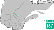
Route 167 is an isolated provincial highway in Quebec, Canada. It begins at the shore of Lac Saint-Jean in Saint-Félicien. It proceeds north-west to Chibougamau...
4 KB (333 words) - 06:59, 17 April 2023

along Quebec Route 169 between the village of Chambord itself and Roberval. Chambord is at the intersection of Quebec highways 155 and 169, and is also...
7 KB (263 words) - 15:45, 30 May 2024

Transports (2001). "Enlargement Southern Québec" (Map). Québec Official Road Map. 1:250000. Les Publications du Québec. Montréal and vicinity inset. Wikimedia...
13 KB (404 words) - 21:18, 6 January 2024
Réaménagement de la route 185 en autoroute". Archived from the original on 2018-09-25. Retrieved 2016-10-26. Canada portal Roads portal Transports Québec autoroutes...
8 KB (547 words) - 20:07, 4 May 2024
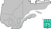
lengthy negotiations between the Québec and federal governments to fund the project, work was begun to completely rebuild Route 175 as a four-lane dual carriageway...
13 KB (360 words) - 15:12, 25 April 2024

List of Quebec provincial highways Ministère des transports, "Distances routières", page 80, Les Publications du Québec, 2005 Provincial Route Map (Courtesy...
10 KB (264 words) - 23:37, 19 January 2024

(French pronunciation: [bekɑ̃kuʁ]) is a city in the Centre-du-Québec region of Quebec, Canada; it is the seat of the Bécancour Regional County Municipality...
13 KB (795 words) - 16:07, 3 June 2024

northern Quebec via Quebec Route 167 and from locations around the lake and elsewhere across central and southern Quebec via Quebec Route 169. The town...
10 KB (778 words) - 05:47, 28 January 2023

Arterial Hwy, Route 169 Replacement, Little Falls: Environmental. NYSDOT. 1975. p. 34. Retrieved March 30, 2020. Southeast Arterial Hwy, Route 169 Replacement...
124 KB (1,299 words) - 17:28, 25 July 2024

territory was home to the former RCAF Station Mont Apica, located along Quebec Route 169 at the base of the namesake Mount Apica. Part of the Pinetree Line...
6 KB (281 words) - 05:30, 28 January 2023
retrieved 2010-03-28 2009 Minnesota Statutes (2009), 169.87 Seasonal Load Restriction; Route Designation., retrieved 2010-03-29{{citation}}: CS1 maint:...
3 KB (291 words) - 21:57, 13 January 2021

they are referred to as "penguins" by Hydro-Québec linemen. Pylons for other voltage levels Hydro-Québec TransÉnergie uses a combination of double-circuit...
64 KB (6,724 words) - 03:50, 31 July 2024

boundary of the territory is Bark River (Rivière aux Écorces), while Quebec Route 169 forms the eastern boundary. The eponymous Lake Achouakan (48°06′34″N...
5 KB (189 words) - 05:19, 28 January 2023
aux Écorces. The upper part of the Apica valley is accessible by the route 169 (route d'Iberville); other secondary forest roads have been developed in the...
10 KB (1,205 words) - 21:17, 26 June 2024

Baie-Comeau (redirect from Baie-Comeau, Québec)
"Banque de noms de lieux du Québec: Baie Comeau". toponymie.gouv.qc.ca (in French). Commission de toponymie du Québec. Retrieved 2024-06-18. "Baie-Comeau...
25 KB (2,019 words) - 00:43, 28 July 2024

Maria-Chapdelaine Regional County Municipality (redirect from Maria-Chapdelaine County Regional Municipality, Quebec)
territories in Quebec "Banque de noms de lieux du Québec: Reference number 141059". toponymie.gouv.qc.ca (in French). Commission de toponymie du Québec. "Ministère...
9 KB (474 words) - 20:15, 5 August 2023

border near Third Connecticut Lake, where it connects to Quebec Route 257. Massachusetts Route 3 connects to the southern terminus of US 3 in Cambridge...
55 KB (3,184 words) - 21:33, 14 July 2024
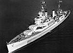
HMS Uganda (66) (redirect from HCMS Québec (C66))
September 1960. p. 3. "Quebec Pays Last Visit to Halifax". The Crowsnest. Vol. 12, no. 12. Queen's Printer. October 1960. p. 3. "NCSM Québec : la fin d'une grande...
24 KB (2,654 words) - 12:56, 23 January 2024
Zec de la Rivière-aux-Rats (category 1978 establishments in Quebec)
Path to get there: from the route 169 to Dolbeau-Mistassini, continue on route 169 South to rang Saint-Louis. Continue on Route des Trappistes; continue...
4 KB (457 words) - 20:49, 30 August 2021

New England road marking system (redirect from New England Interstate Route 17)
Route 9 and Route 11 in Wells and Biddeford, respectively. The highway met three route termini in Portland: Route 18, Route 25, and Route 26. Route 1...
158 KB (6,445 words) - 17:10, 1 February 2024
from Quebec, to Canada. Lac aux Écorces is part of the Laurentides Wildlife Reserve. The area around the lake is served indirectly by the route 169 (connecting...
6 KB (578 words) - 10:24, 2 May 2023
in Quebec City. Route 54C, now 1re Avenue in Quebec City. Route 55, now Route 169 around Lac Saint-Jean. Route 56, now Route 381. Route 57, now Route 323...
11 KB (963 words) - 17:08, 15 February 2023
Oka Crisis (category Conflicts in Quebec)
Retrieved June 8, 2024. Levac, Chénier (1998). Le problème Mohawk au Québec. Laval, Québec: Éditions Chénier Levac. pp. 57–73. ISBN 2-9805593-0-X. OCLC 39380322...
53 KB (6,072 words) - 15:56, 12 July 2024
List of highways numbered 1 (redirect from State Route 1)
Nova Scotia Trunk 1 Northwest Territories Highway 1 Quebec Route 1 (former) Yukon Highway 1 Chile Route 1 G1 Expressway G1N Expressway G0111 Expressway S01...
20 KB (1,278 words) - 14:46, 3 August 2024