
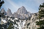
The San Emigdio Mountains are a part of the Transverse Ranges in Southern California, extending from Interstate 5 at Lebec and Gorman on the east to Highway...
4 KB (364 words) - 17:08, 26 September 2022

San Emigdio (Spanish pronunciation: [san eˈmiɣðjo]) is a municipality in the La Paz department of El Salvador. v t e...
5 KB (20 words) - 04:01, 15 August 2024
The San Emigdio Formation is a geologic formation in California. It preserves fossils dating back to the Paleogene period. Earth sciences portal California...
1 KB (58 words) - 08:01, 3 July 2022

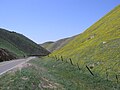
San Emigdio Creek, formerly Arroyo de San Emigdio (Spanish for Saint Emygdius Creek), is a 33 kilometres (21 mi) northward-flowing stream in western Kern...
7 KB (529 words) - 01:56, 27 September 2023
San Emigdio Mountain is in the San Emigdio Mountains, located in Kern County, a few miles north of the Ventura County border in Southern California. San...
2 KB (118 words) - 03:22, 2 February 2021
known as Lycaenidae San Emigdio Formation, geologic formation in California San Emigdio Mountain, in the San Emigdio Mountains San Emigdio Mountains, part...
1 KB (203 words) - 09:19, 3 October 2018
1857 Fort Tejon earthquake (category San Emigdio Mountains)
Tejon is just north of the junction of the San Andreas and Garlock Faults, where the Tehachapi, San Emigdio, and Sierra Pelona Transverse Ranges come together...
25 KB (2,834 words) - 20:40, 21 June 2024

Pyramid Lake (Los Angeles County, California) (category San Emigdio Mountains)
Lake is a reservoir formed by Pyramid Dam on Piru Creek in the eastern San Emigdio Mountains, near Castaic, Southern California. It is a part of the West...
9 KB (773 words) - 22:58, 24 June 2024

Tehachapi Mountains (category Geography of the San Joaquin Valley)
with the San Emigdio Mountains on the west and Sierra Pelona Mountains on the southwest. The Tehachapis are delineated from the San Emigdio Mountains...
16 KB (1,667 words) - 20:58, 6 November 2023

Lebec, California (category San Emigdio Mountains)
population was 1,239. Lebec is located in Castac Valley between the San Emigdio and Tehachapi Mountains. The community is one of the Mountain Communities...
22 KB (1,799 words) - 04:16, 31 July 2024

Pelona-San Emigdio Mountains juncture area to the western San Gabriel Mountains that forms their southwestern face near Sunland and the northeastern San Fernando...
7 KB (841 words) - 16:09, 20 May 2024

Tejon Pass (category San Emigdio Mountains)
between the southwest end of the Tehachapi Mountains and northeastern San Emigdio Mountains, linking Southern California north to the Central Valley. Both...
22 KB (2,391 words) - 06:37, 14 August 2024

Pine Mountain Club, California (category San Emigdio Mountains)
in elevation. The community sits in a deep valley of the San Emigdio Mountains, on the San Andreas fault. It is surrounded by Los Padres National Forest...
22 KB (2,122 words) - 05:50, 26 June 2024

Frazier Park, California (category San Emigdio Mountains)
billion-dollar ticket. Frazier Park lies within Cuddy Canyon in the San Emigdio Mountains, within the Los Padres National Forest. Mount Pinos is the...
20 KB (1,823 words) - 21:21, 11 August 2024

Ridge Route (category San Emigdio Mountains)
the first paved highway directly linking the Los Angeles Basin with the San Joaquin Valley (southern Central Valley) over the Tejon Pass and the rugged...
34 KB (4,021 words) - 10:21, 15 August 2024
Hills San Bernardino Mountains San Emigdio Mountains San Felipe Hills (Santa Clara County) San Felipe Hills (San Diego County) San Gabriel Mountains San Jacinto...
13 KB (1,132 words) - 02:10, 30 January 2024
Temblor Range (category Mountain ranges of San Luis Obispo County, California)
the adjacent mountain range. The Temblor Range is delineated from the San Emigdio Mountains and the Santa Ynez Mountains by State Route 166 in Maricopa...
7 KB (694 words) - 16:01, 2 August 2023

List of rivers of California (section San Pablo Bay (south of Carquinez Strait) and San Francisco Bay)
Pastoria Creek Grapevine Creek Tecuya Creek Salt Creek Pleito Creek San Emigdio Creek Los Lobos Creek Santiago Creek Bitter Creek Bitterwater Creek Sandy...
69 KB (5,982 words) - 14:57, 24 June 2024

Ceiba Paraíso de Osorio San Antonio Masahuat San Emigdio San Juan Tepezontes San Luis La Herradura San Miguel Tepezontes San Pedro Nonualco Santa María...
11 KB (772 words) - 21:25, 19 July 2024
Kern County, California (category San Joaquin Valley)
ejecting the natives. The battle occurred in the canyon where San Emigdio Creek flows down San Emigdio Mountain and the Blue Ridge, south of Bakersfield near...
121 KB (6,590 words) - 05:21, 17 August 2024
Plebulina emigdionis (redirect from San Emigdio blue)
Plebulina emigdionis (formerly known as Plebejus emigdionis), the San Emigdio blue, is a species of blue in the family of butterflies known as Lycaenidae...
2 KB (112 words) - 14:28, 1 February 2024

Gorman, California (category San Emigdio Mountains)
namely the Sierra Pelona Mountains, the Tehachapi Mountains, and the San Emigdio Mountains. One of the Mountain Communities of the Tejon Pass, it is southeast...
28 KB (3,086 words) - 03:22, 15 August 2024
Tejon Indian Tribe (category San Emigdio Mountains)
people of California. Their ancestral homeland is the southern San Joaquin Valley, San Emigdio Mountains, and Tehachapi Mountains. Today they live in Kern...
4 KB (330 words) - 14:45, 5 August 2024

including the San Emigdio Mountains, the southernmost part of Tehachapi Mountains and the Sierra Pelona Mountains. Los Angeles County includes San Clemente...
123 KB (7,560 words) - 03:38, 20 August 2024

people of California. Their ancestral homeland is the southern San Joaquin Valley, San Emigdio Mountains, and Tehachapi Mountains. Today they live in Kern...
66 KB (7,226 words) - 14:02, 21 August 2024
Salmon Mountains. The summit of Mount Pinos is the highest point of the San Emigdio Mountains. The summit of Mount Linn is the highest point of the Northern...
54 KB (5,512 words) - 00:21, 24 February 2024

Bernardino Counties) San Bernardino Valley (San Bernardino County) San Diego Bay (San Diego County) San Diego River (San Diego County) San Emigdio Mountains (Los...
80 KB (6,582 words) - 03:46, 19 August 2024

Little San Bernardino Mountains, California Pine Mountain Ridge, California Puente Hills, California San Bernardino Mountains, California San Emigdio Mountains...
51 KB (4,774 words) - 13:49, 4 August 2024
is located 35 miles (56 km) southwest of Bakersfield and features the San Emigdio Mountains and Pleito Hills. It is the largest nonprofit nature reserve...
15 KB (1,301 words) - 05:33, 13 May 2024

California Sierra Pelona Mountains, Southern California San Emigdio Mountains, Southern California San Rafael Mountains, Southern California Santa Ynez Mountains...
17 KB (1,775 words) - 14:24, 15 June 2024