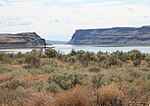
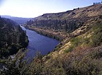
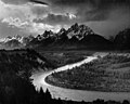
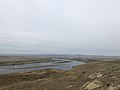
Wallula Gap (/wəˈluːlə/) is a large water gap of the Columbia River in the Northwestern United States, in Southeastern Washington. It cuts through the...
11 KB (1,152 words) - 04:02, 8 September 2024
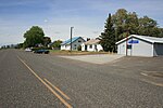
Wallula (/wəˈluːlʌ/) is a census-designated place (CDP) in Walla Walla County, Washington, United States. The population was 179 at the 2010 census. The...
9 KB (873 words) - 14:03, 9 August 2024

Lake Lewis (section Wallula Gap)
the Yakima, Walla Walla, Touchet and Tucannon river valleys. Wallula Gap is a large water gap through basalt anticlines in the Columbia River basin just...
9 KB (727 words) - 04:02, 8 September 2024
Oregon and Washington, and Wallula Gap, Washington, United States Cumberland Narrows, Maryland, United States Delaware Water Gap, New Jersey and Pennsylvania...
4 KB (363 words) - 04:14, 19 July 2024
recreational activities. Wallula Gap List of lakes in Oregon List of hydroelectric dams on the Columbia River "Lake Wallula - Washington Department of...
2 KB (117 words) - 21:52, 27 July 2024

the south side of the Kittitas Valley (I-90), Manastash Ridge, the Wallula Gap (on the Columbia River where it approaches the Oregon state line), and...
118 KB (14,439 words) - 00:38, 14 September 2024
showed. For example, their calculated water depth at the Pasco Basin–Wallula Gap transition zone is about 190 m, significantly less than the 280–300 m...
24 KB (2,961 words) - 05:56, 5 September 2024

is a tributary of the Columbia River, joining the Columbia just above Wallula Gap in southeastern Washington in the United States. The river flows through...
9 KB (877 words) - 04:38, 20 July 2024

Umatilla, leading to several attempts at finding a compromise along the Wallula Gap or in other areas southeast of the Tri-Cities. In 1973, Oregon and Washington...
96 KB (8,847 words) - 23:08, 16 August 2024

range. The Horse Heaven Hills lead eastward from the Simcoe Mountains to Wallula Gap. The range is bounded in the west by Satus Creek near Bickleton, the...
40 KB (4,009 words) - 22:07, 4 May 2024
made way down the Columbia river Channel where a 'choke-point' known as Wallula Gap caused the restriction of flow. Floodwaters began ponding near the Tri-Cities...
14 KB (1,240 words) - 01:31, 17 May 2024

exposed these lava flows, laying bare many layers of the basalt flows at Wallula Gap, the lower Palouse River, the Columbia River Gorge and throughout the...
35 KB (4,212 words) - 06:33, 25 August 2024

type former lake Primary inflows Channeled Scablands Primary outflows Wallula Gap of the Columbia River Basin countries United States Max. length 200 mi...
23 KB (2,487 words) - 03:13, 9 May 2024
Old Cariboo Road (redirect from Wallula-Okanogan Road)
known as a "road train", one of the earliest motorized vehicles. From Wallula Gap on the Columbia River, the Old Cariboo Trail was built over the route...
6 KB (749 words) - 09:48, 4 May 2020

surrounds it, as they are often carried very far from their origin. Wallula Gap – Large water gap of the Columbia River through basalt anticlines in the U.S....
16 KB (1,818 words) - 16:32, 17 June 2024

Ocean here and at Wallula Gap, this opening was "repeatedly reamed out, which probably widened and steepened the walls of the gap". Strandlines from...
2 KB (295 words) - 23:41, 2 July 2022
Sims Corner Eskers and Kames Steptoe and Kamiak Buttes Umtanum Ridge Water Gap Wallula Gap Withrow Moraine and Jameson Lake Drumlin Field Davis Canyon List of...
8 KB (135 words) - 19:08, 24 May 2024

400 to 15,700 calendar years ago. During the floods, flow through the Wallula Gap was slow enough such that water pooled in a temporary lake, Lake Lewis...
30 KB (2,956 words) - 00:50, 24 August 2024
Territory, taking with it areas north of the Columbia River (west of Wallula Gap) and the 46th parallel. Olympia is established as the capital. 1855:...
23 KB (2,368 words) - 09:04, 19 August 2024
Salmon-Clearwater was established in the Columbia River's modern path through Wallula Gap, although the Columbia itself still flowed somewhere to the west. The...
153 KB (16,206 words) - 20:06, 15 September 2024

deposited. Water depths have been estimated at 1,000 feet (300 m) at Wallula Gap and 400 feet (120 m) over modern Portland, Oregon. Sediments were also...
196 KB (18,315 words) - 01:24, 7 September 2024
Columbia River on the Washington/Oregon border above The Dalles and below Wallula Gap. Lake Lewis; 16,000 YBP in central Washington, new Yakima. Glacial Lake...
26 KB (3,072 words) - 20:38, 16 September 2024

from the eastern entrance of the Columbia River Gorge upstream to the Wallula Gap to form ancient Lake Condon. Elevation varies from 300 to 1,200 feet...
19 KB (2,076 words) - 04:13, 1 September 2024

viticultural area in southeast Washington and northeast Oregon, east of Lake Wallula, to be known as "Walls Walls Valley." At the time, Walla Walla Valley viticultural...
11 KB (996 words) - 04:00, 21 August 2024

rough-plucked surface characteristic of kolk-eroded rock. Both the walls of the Wallula Gap and the Columbia River Gorge also show the rough-plucked surfaces characteristic...
4 KB (438 words) - 13:30, 3 June 2024
formation are buried by other sediment deposits, extending as far as Wallula Gap southeast of Kennewick. In recent years, irrigation water entering the...
11 KB (1,107 words) - 22:39, 16 September 2022

(Dalles Group, etc.) exposed in tributary stream valleys downstream of Wallula Gap Miocene-Pliocene Snipes Mountain Conglomerate in the Yakima Valley at...
23 KB (3,086 words) - 12:15, 28 August 2024

the Missoula Floods have been estimated at 1,250 feet (380 m) at the Wallula Gap (in present-day Washington), 830 feet (250 m) at Bonneville Dam, and...
48 KB (5,618 words) - 05:06, 15 August 2024

of irregular buttes and basins and the Columbia River Gorge past the Wallula Gap. An unmarked tour route connects a network of state parks and other featured...
60 KB (2,726 words) - 20:04, 14 July 2024
with deep sheer-walled canyons in the Grand Coulee, Moses Coulee, the Wallula Gap, and the Columbia River Gorge. There are giant ripple marks 30 ft (9...
9 KB (1,046 words) - 07:03, 6 May 2024