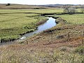
Yarrowitch River, a perennial stream of the Macleay River catchment, is located in the Northern Tablelands district of New South Wales, Australia. Yarrowitch...
4 KB (166 words) - 04:47, 26 January 2024
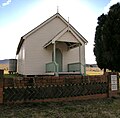
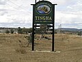
Yarrowitch is a small rural locality on the Northern Tablelands, New South Wales, Australia. It is located in the picturesque Yarrowitch River Valley on...
5 KB (685 words) - 00:25, 19 June 2023
north within Oxley Wild Rivers National Park before reaching its confluence with the Yarrowitch River, northeast of Yarrowitch; descending 577 metres (1...
4 KB (134 words) - 15:16, 25 January 2024

Yarrangobilly Yarrow Yarrowitch Yarrunga Yass Yowaka Yowrie Rivers of the Northern Territory template Adelaide Alligator Rivers East Alligator South Alligator...
84 KB (2,294 words) - 22:11, 7 August 2024
main rivers in the national park are the: Apsley River, Macleay River, Wollomombi River, Chandler River, Tia River, Styx River, Gara River, Yarrowitch River...
35 KB (4,454 words) - 22:17, 11 January 2024
This page discusses the rivers and hydrography of the state of New South Wales, Australia. The principal topographic feature of New South Wales is the...
21 KB (546 words) - 16:43, 19 December 2023
to intersect with Thunderbolts Way at Walcha, continuing east through Yarrowitch, Ellenborough, Long Flat, Wauchope, and intersects with Pacific Highway...
16 KB (1,281 words) - 06:02, 13 August 2024

River and Yarrowitch River, as it makes its course, descending 1,070 metres (3,510 ft) over 168 kilometres (104 mi). Together with the Macleay River,...
11 KB (1,032 words) - 10:22, 23 August 2022
South Wales, Australia. Rowleys River rises on the eastern slopes of the Great Dividing Range, southeast of Yarrowitch, and flows generally south southeast...
4 KB (168 words) - 09:17, 4 December 2022

Wellingrove Werris Creek Willow Tree Wollomombi Wollun Woolbrook Wytaliba Yarrowitch Yarrowyck Yetman National parks and other conservation areas Bald Rock...
10 KB (1,093 words) - 18:33, 12 September 2024

Niangala, Nowendoc, Woolbrook, Brackendale, Glen Morrison, Ingalba, Tia and Yarrowitch. History was made at Walcha in 1950 when a Tiger Moth was the first aircraft...
33 KB (3,722 words) - 18:24, 16 June 2024

and regional tourism. Local attractions include Pindari Dam on the Severn River, MacIntyre Falls, the annual Ashford Salami Festival and Ashford Caves at...
3 KB (287 words) - 19:43, 23 April 2024

mean 'meeting of the rivers'. The township of Manilla was established in 1853 at the junction of the Namoi River and the Manilla River. It was formerly the...
16 KB (1,712 words) - 21:55, 17 October 2024
Wellingrove Werris Creek Willow Tree Wollomombi Wollun Woolbrook Wytaliba Yarrowitch Yarrowyck Yetman National parks and other conservation areas Bald Rock...
2 KB (118 words) - 14:48, 3 July 2023
New South Wales, Australia. Cells River rises on the eastern slopes of the Great Dividing Range, southeast of Yarrowitch, and flows generally southeast before...
4 KB (143 words) - 22:43, 3 December 2022

protected national park located in the catchment zone of the Upper Hastings River in New South Wales, Australia. Gazetted in 1975, the 33,309-hectare (82...
9 KB (817 words) - 19:20, 23 October 2022
Wellingrove Werris Creek Willow Tree Wollomombi Wollun Woolbrook Wytaliba Yarrowitch Yarrowyck Yetman National parks and other conservation areas Bald Rock...
11 KB (1,044 words) - 00:29, 23 April 2024

a river crossing on what would become the McDonald River. By 1851 a small village had grown around the station, which was known as McDonald River. In...
7 KB (634 words) - 23:08, 13 October 2024

Bingara (Aboriginal for 'creek') is a small town on the Gwydir River in Murchison County in the New England region of New South Wales, Australia. Bingara...
12 KB (912 words) - 00:27, 19 January 2024

The village is on the northern bank of the Deepwater River which is a tributary of the Mole River. Deepwater is a popular tourist destination for people...
6 KB (629 words) - 20:12, 26 September 2024

Wakool River, an anabranch of the Edward River that is part of the Murray River catchment within the Murray–Darling basin, is located in the western Riverina...
4 KB (185 words) - 23:28, 27 April 2022

north-eastern region of New South Wales, Australia. Situated on the Peel River within the local government area of the Tamworth Regional Council, it is...
69 KB (7,130 words) - 06:01, 17 October 2024

Carne Creek (also called Wolgan River (Eastern Branch)) and Wolgan River (Western Branch), the headwaters of the Wolgan River rise on the eastern slopes of...
4 KB (201 words) - 11:19, 8 June 2022

cafes. It is still possible to pan for gold in the rivers around the town, including the Rocky River. Today, the area is used for raising Merino sheep...
16 KB (1,632 words) - 10:14, 15 August 2024

Wellingrove Werris Creek Willow Tree Wollomombi Wollun Woolbrook Wytaliba Yarrowitch Yarrowyck Yetman National parks and other conservation areas Bald Rock...
11 KB (1,161 words) - 21:02, 4 November 2023
north-east New South Wales. It is located next to the Mann River, between the Mann River Nature Reserve and Barool National Park, about 40 km east of...
4 KB (299 words) - 12:18, 10 October 2024
Wellingrove Werris Creek Willow Tree Wollomombi Wollun Woolbrook Wytaliba Yarrowitch Yarrowyck Yetman National parks and other conservation areas Bald Rock...
2 KB (49 words) - 12:52, 25 October 2020
This is a list of schools in the Northern Rivers and Mid North Coast regions of New South Wales, Australia. The New South Wales education system traditionally...
87 KB (358 words) - 01:41, 30 August 2024

The town is located on Thunderbolts Way and on the banks of the Gwydir River, in the Uralla Shire local government area, 563 kilometres (350 mi) from...
8 KB (791 words) - 02:59, 15 February 2023
Wellingrove Werris Creek Willow Tree Wollomombi Wollun Woolbrook Wytaliba Yarrowitch Yarrowyck Yetman National parks and other conservation areas Bald Rock...
962 bytes (69 words) - 11:19, 27 January 2024