
Tasman District (Māori: Te Tai o Aorere) is a local government district in the northwest of the South Island of New Zealand. It borders the Canterbury...
25 KB (1,688 words) - 23:55, 18 October 2024
up Tasman in Wiktionary, the free dictionary. Tasman most often refers to Abel Tasman (1603–1659), Dutch explorer. Tasman may also refer to: Tasman booby...
3 KB (453 words) - 16:16, 4 January 2024

Tasman District Council in New Zealand. It lies 13 kilometres (8 mi) south of Nelson in the South Island, close to the southern extremity of Tasman Bay...
22 KB (1,490 words) - 06:18, 4 October 2024

Abel Janszoon Tasman (Dutch: [ˈaːbəl ˈjɑnsoːn ˈtɑsmɑn]; 1603 – 10 October 1659) was a Dutch seafarer and explorer, best known for his voyages of 1642...
41 KB (4,908 words) - 22:39, 17 October 2024
Tasman District Council (Māori: Te Kaunihera o te tai o Aorere) is the unitary local authority for the Tasman District of New Zealand. The council is led...
7 KB (437 words) - 19:49, 23 September 2024
Brooklyn is a settlement and rural valley in the Tasman District of New Zealand's upper South Island. It is located on the outskirts of Motueka, and is...
7 KB (560 words) - 12:41, 28 April 2024
Waitaki District Queenstown 29,000 Otago Queenstown Lakes District Rangiora 19,600 Canterbury Waimakariri District Richmond 19,200 Tasman Tasman District Rolleston...
26 KB (188 words) - 00:16, 21 September 2024
Tasman (often known as the Tasman Mako and formerly Tasman Makos) are a New Zealand professional rugby union team based in Tasman Bay / Te Tai-o-Aorere...
16 KB (595 words) - 21:06, 18 October 2024
Rotomairewhenua Blue Lake Blue lake Rotomairewhenua Location Tasman Region, South Island Coordinates 42°3′30.6″S 172°39′25.6″E / 42.058500°S 172.657111°E...
6 KB (500 words) - 00:01, 16 June 2024

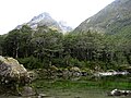
Abel Tasman National Park is a national park at the north end of New Zealand's South Island. It covers 237.1 km2 (91.5 sq mi) of land between Golden Bay...
18 KB (1,809 words) - 06:50, 28 September 2024

areas. Three districts (Gisborne, Tasman, and Marlborough) are unitary authorities also performing the functions of a regional council. Districts are not subdivisions...
6 KB (501 words) - 08:06, 22 July 2024
The Tasman Rugby Union is the governing body for rugby union in Tasman Bay / Te Tai-o-Aorere, a bay at the north end of the South Island in New Zealand...
35 KB (2,934 words) - 04:11, 13 October 2024

The Tasman Region, and the small adjoining Nelson Region, form one of the more geologically interesting regions of New Zealand. It contains the oldest...
15 KB (1,976 words) - 22:19, 14 July 2024
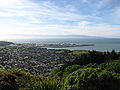
Nelson, New Zealand (category Populated places around Tasman Bay / Te Tai-o-Aorere)
the west and south-west by the Tasman District and to the north-east, east and south-east by the Marlborough District. The Nelson urban area has a population...
113 KB (9,825 words) - 00:09, 19 October 2024
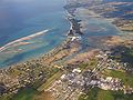
Tasman Bay (Māori: Te Tai-o-Aorere; officially Tasman Bay / Te Tai-o-Aorere), originally known in English as Blind Bay, is a large V-shaped bay at the...
5 KB (411 words) - 09:15, 8 June 2024

Wai-iti River, which meet near Brightwater. The combined waters flow into Tasman Bay / Te Tai-o-Aorere near Appleby, opposite Rabbit Island. "Environmental...
3 KB (84 words) - 02:47, 13 April 2024
Glenroy River (category Rivers of the Tasman District)
(New Zealand) Show map of New Zealand Location Country New Zealand District Tasman Physical characteristics Source Glenroy River (main branch) • location...
2 KB (39 words) - 00:17, 16 June 2024
This is a list of radio stations in Nelson and Tasman, New Zealand. Most stations in Nelson and Tasman are based in Nelson. "The Register of Radio Frequencies"...
8 KB (72 words) - 11:53, 8 May 2023
Boulder River (New Zealand) (category Rivers of the Tasman District)
This article about a river in the Tasman District is a stub. You can help Wikipedia by expanding it....
2 KB (46 words) - 00:39, 14 April 2024

Wharariki Beach (category Beaches of the Tasman District)
Wharariki Beach is a beach on the Tasman Sea, west of Cape Farewell, the northernmost point of the South Island of New Zealand. The north-facing sandy...
4 KB (319 words) - 04:58, 2 October 2024
Motueka (category Populated places in the Tasman District)
western shore of Tasman Bay. It is the second largest in the Tasman Region, with a population of 8,320 as of June 2023. The surrounding district has a number...
45 KB (3,786 words) - 06:15, 4 October 2024

Slate River (New Zealand) (category Rivers of the Tasman District)
This article about a river in the Tasman District is a stub. You can help Wikipedia by expanding it....
2 KB (26 words) - 00:41, 14 April 2024
Park, Victoria Saint Arnaud, New Zealand, in the Tasman District Saint Arnaud Range, Tasman District, New Zealand Arnaud (disambiguation) This disambiguation...
690 bytes (110 words) - 03:29, 19 August 2022

Riuwaka River (category Caves of the Tasman District)
northwest of New Zealand's South Island. It flows for 20 kilometres, entering Tasman Bay close to the town of Riwaka, 10 kilometres north of Motueka. The valleys...
4 KB (224 words) - 00:41, 14 April 2024
Serpentine River (New Zealand) (category Rivers of the Tasman District)
town of Richmond before joining the Roding River, eventually emptying into Tasman Bay. 41°24′S 173°12′E / 41.400°S 173.200°E / -41.400; 173.200 v t e v...
763 bytes (66 words) - 17:56, 22 April 2024
Hills Ruby Bay-Māpua Murchison-Nelson Lakes Inlet Waimea West Islands Tasman District Waimea West Appleby Wakefield Richmond West Wakefield Rural Brightwater...
62 KB (4,617 words) - 09:01, 19 August 2024

Zealand were found near the Anaweka estuary in a remote part of the Tasman District and radiocarbon-dated to about 1400. The canoe was constructed in New...
24 KB (3,237 words) - 09:36, 4 August 2024

National Park. It is the highest point in Westland District.[citation needed] The first ascent of Mount Tasman was in 1895 by Edward FitzGerald and his guide...
4 KB (337 words) - 20:46, 22 July 2024

Murchison, New Zealand (category Populated places in the Tasman District)
Murchison is a town in the Tasman Region of the South Island of New Zealand. It is near the western end of the "Four Rivers Plain", at the confluence of...
20 KB (1,791 words) - 23:57, 11 August 2024
Nzhistory.net.nz. Retrieved 30 March 2015. "January 1923 Canterbury and Tasman-Nelson Flooding - HWE". Hwe.niwa.co.nz. Retrieved 30 March 2015. "March...
51 KB (1,783 words) - 04:39, 9 September 2024