List of minor planets: 71001–72000 (redirect from 71556 Page)
columns and additional sources are given on the main page including a complete list of every page in this series, and a statistical break-up on the dynamical...
170 KB (301 words) - 15:43, 30 April 2024

Guthrie Castle (category Pages using gadget WikiMiniAtlas)
Archived 2 October 2017 at the Wayback Machine Guthrie Castle, Gazetteer for Scotland 56°38′38″N 2°42′56″W / 56.64389°N 2.71556°W / 56.64389; -2.71556...
3 KB (310 words) - 03:01, 7 June 2023
Padua 9700 Paech 1061 Paeonia 1032 Pafuri 16110 Paganetti 2859 Paganini 71556 Page 3807 Pagels 120040 Pagliarini 10306 Pagnol 32146 Paigebrown 27589 Paigegentry...
47 KB (2,581 words) - 00:31, 8 July 2024

Post Tower (category Pages using gadget WikiMiniAtlas)
bei CTBUH. skyscrapercenter.com. Wikimedia Commons has media related to Post Tower. 50°42′56″N 7°07′48″E / 50.71556°N 7.13000°E / 50.71556; 7.13000...
5 KB (455 words) - 16:54, 9 August 2024
71489 Dynamocamp 71538 Robertfried 71539 VanZandt 71555 Manuecharpentier 71556 Page 71615 Ramakers 71669 Dodsonprince 71783 Izeryna 71855 Incamajorca 71885...
12 KB (666 words) - 14:53, 25 August 2024

Corrachadh Mòr (category Pages using gadget WikiMiniAtlas)
Ardnamurchan Point lighthouse Corrachadh Mòr Coordinates: 56°42′56″N 06°13′41″W / 56.71556°N 6.22806°W / 56.71556; -6.22806 Grid position NM 41389 66199...
5 KB (166 words) - 19:57, 4 July 2024

Patriot Park (category Pages using gadget WikiMiniAtlas)
Official website Kubinka, Moscow Oblast, Russia Coordinates 55°33′57.5″N 36°42′56″E / 55.565972°N 36.71556°E / 55.565972; 36.71556 Opened 2016 (2016)...
6 KB (403 words) - 02:11, 29 August 2024
Planck Institute for Infection Biology, Berlin IAU · 71555 71556 Page 2000 DW17 Gary L. Page (born 1947) is an American physicist and astrophysicist at...
8 KB (419 words) - 10:16, 29 June 2024
Cathrines Rest, U.S. Virgin Islands (category Pages using gadget WikiMiniAtlas)
Geographic Names Information System: Cathrines Rest, U.S. Virgin Islands 17°43′21″N 64°42′56″W / 17.72250°N 64.71556°W / 17.72250; -64.71556 v t e...
2 KB (52 words) - 11:25, 2 June 2022
Abundant Church (category Pages using gadget WikiMiniAtlas)
News. Archived from the original on 2011-07-16. Retrieved 2010-08-08. 31°42′56″N 106°18′41″W / 31.71556°N 106.31139°W / 31.71556; -106.31139 v t e...
9 KB (683 words) - 00:03, 7 June 2024
Fareham, U.S. Virgin Islands (category Pages using gadget WikiMiniAtlas)
Survey Geographic Names Information System: Fareham, U.S. Virgin Islands 17°42′56″N 64°40′14″W / 17.71556°N 64.67056°W / 17.71556; -64.67056 v t e...
2 KB (50 words) - 11:10, 9 July 2021

Howard City, Nebraska (category Pages using gadget WikiMiniAtlas)
Nebraska Coordinates: 41°04′31″N 98°42′56″W / 41.07528°N 98.71556°W / 41.07528; -98.71556 Country United States State Nebraska County Howard Area • Total...
10 KB (887 words) - 17:03, 22 August 2024
Fries, Virginia (category Pages using gadget WikiMiniAtlas)
(kilometer 342.8). Fries is located at 36°42′56″N 80°58′33″W / 36.71556°N 80.97583°W / 36.71556; -80.97583 (36.715537, −80.975849). According to the United...
13 KB (1,384 words) - 22:33, 12 May 2024

Mid Ulster (Assembly constituency) (category Pages using gadget WikiMiniAtlas)
1973". EONI. Archived from the original on 6 August 2019. Retrieved 23 August 2021. 54°44′08″N 6°42′56″W / 54.73556°N 6.71556°W / 54.73556; -6.71556...
62 KB (478 words) - 18:02, 4 August 2024

Jeannette Island (category Pages using gadget WikiMiniAtlas)
USS Jeannette Geography Coordinates 76°42′56″N 158°06′33″E / 76.71556°N 158.10917°E / 76.71556; 158.10917 Archipelago De Long Islands Area 3.3 km2 (1.3 sq mi)...
9 KB (1,038 words) - 04:38, 16 January 2024

Ibicuy Islands (category Pages using gadget WikiMiniAtlas)
Las islas de la fantasía Archived 2007-08-09 at the Wayback Machine 33°42′56″S 58°54′28″W / 33.71556°S 58.90778°W / -33.71556; -58.90778 v t e v t e...
3 KB (368 words) - 08:46, 31 August 2024

Örnsköldsvik (category Pages using gadget WikiMiniAtlas)
Sweden Coordinates: 63°17′27″N 18°42′56″E / 63.29083°N 18.71556°E / 63.29083; 18.71556 Country Sweden Province Ångermanland County Västernorrland County...
15 KB (1,440 words) - 15:14, 26 July 2024
DHL Group (category Pages using gadget WikiMiniAtlas)
50°42′56″N 7°07′48″E / 50.71556°N 7.13000°E / 50.71556; 7.13000 Deutsche Post AG, trading as DHL Group, is a German multinational package delivery...
25 KB (2,260 words) - 19:58, 12 August 2024

Onarga, Illinois (category Pages using gadget WikiMiniAtlas)
located in western Iroquois County at 40°42′56″N 88°0′25″W / 40.71556°N 88.00694°W / 40.71556; -88.00694 (40.715432, -88.006928). U.S. Route 45 passes through...
11 KB (977 words) - 05:52, 28 July 2024
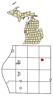
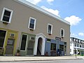
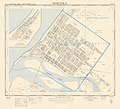
Walkerville, Michigan (category Pages using gadget WikiMiniAtlas)
Walkerville, Michigan Coordinates: 43°42′56″N 86°7′22″W / 43.71556°N 86.12278°W / 43.71556; -86.12278 Country United States State Michigan County Oceana...
10 KB (986 words) - 22:06, 13 May 2024
Century Village, Florida (category Pages using gadget WikiMiniAtlas)
unincorporated place Coordinates: 26°42′56″N 80°7′34″W / 26.71556°N 80.12611°W / 26.71556; -80.12611 Country United States State Florida County Palm...
9 KB (677 words) - 04:07, 11 July 2024
Abengourou Airport (category Pages using gadget WikiMiniAtlas)
Elevation AMSL 676 ft / 206 m Coordinates 6°42′56″N 3°28′13″W / 6.71556°N 3.47028°W / 6.71556; -3.47028 Map Abengourou Runways Source: Google Maps...
2 KB (35 words) - 14:49, 20 April 2022

Kubinka Tank Museum (category Pages using gadget WikiMiniAtlas)
Russia Coordinates 55°33′54″N 36°42′56″E / 55.56500°N 36.71556°E / 55.56500; 36.71556 Key holdings Panzerkampfwagen VIII Maus, Karl-Gerät, Object...
10 KB (1,087 words) - 21:40, 22 July 2024

Lucy Flower Technical High School for Girls (category Pages using gadget WikiMiniAtlas)
Illinois Coordinates 41°53′11″N 87°42′56″W / 41.88639°N 87.71556°W / 41.88639; -87.71556 Built 1927 (1927) Architect John C. Christensen Architectural style...
4 KB (335 words) - 18:54, 25 August 2024
Mukkha Fall (category Pages using gadget WikiMiniAtlas)
India Near Ghorawal Coordinates 24°42′56″N 82°41′47″E / 24.71556°N 82.69639°E / 24.71556; 82.69639 Type Plunges Number of drops 2 Watercourse Belan River...
2 KB (115 words) - 00:41, 27 September 2023

Potosi, Wisconsin (category Pages using gadget WikiMiniAtlas)
Wisconsin. Coordinates: 42°42′10″N 90°42′56″W / 42.70278°N 90.71556°W / 42.70278; -90.71556 Country United States State Wisconsin County Grant Area • Total...
14 KB (1,402 words) - 02:53, 10 June 2024

225 Broadway (San Diego) (category Pages using gadget WikiMiniAtlas)
225 Broadway[usurped] at Emporis.com 225 Broadway at SkyscraperPage.com 32°42′56″N 117°9′44″W / 32.71556°N 117.16222°W / 32.71556; -117.16222 v t e...
3 KB (160 words) - 14:34, 26 August 2024

Montour, Iowa (category Pages using gadget WikiMiniAtlas)
Iowa Coordinates: 41°58′50″N 92°42′56″W / 41.98056°N 92.71556°W / 41.98056; -92.71556 Country United States State Iowa County Tama Area • Total...
10 KB (848 words) - 18:44, 1 July 2024

Village of Four Seasons, Missouri (category Pages using gadget WikiMiniAtlas)
Seasons is located at 38°12′4″N 92°42′56″W / 38.20111°N 92.71556°W / 38.20111; -92.71556 (38.201086, −92.715556). According to the United States Census...
8 KB (767 words) - 16:23, 29 July 2023
Hokitika Borough (category Pages using gadget WikiMiniAtlas)
Districts. Christchurch: The Cyclopedia of New Zealand. Retrieved 23 September 2015. 42°42′56″S 170°58′5″E / 42.71556°S 170.96806°E / -42.71556; 170.96806...
5 KB (470 words) - 07:02, 30 July 2024