
Geography of Iceland Þórsmörk Media related to Þórsmörk (category) at Wikimedia Commons Thorsmork Accommodation Thorsmork Tours Thorsmork Tour Photos Photos...
3 KB (270 words) - 21:36, 17 October 2023
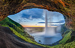
the South Region in Iceland right by Route 1 and the road that leads to Þórsmörk Road 249. The waterfall drops 60 m (197 ft) and is part of the Seljalands...
5 KB (390 words) - 17:56, 8 May 2024

beginning of June. A few oasis-like areas, such as Herðubreiðarlindir and Þórsmörk, are also found in the Highland. The Highland has many notable natural...
6 KB (540 words) - 02:59, 8 July 2024
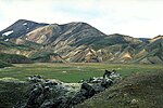
from the hot springs area of Landmannalaugar to the glacial valley of Þórsmörk. It is noted for the wide variety of landscapes on its path: colourful...
8 KB (385 words) - 18:06, 18 November 2023
plan was temporarily dismissed. Instead, the police closed the road to Þórsmörk and the four-wheel-drive trail from Skógar village to the Fimmvörðuháls...
54 KB (5,612 words) - 06:38, 23 June 2024

between the glaciers Eyjafjallajökull and Mýrdalsjökull. It goes down to Þórsmörk on the other side and continues as the Laugavegur trail to Landmannalaugar...
6 KB (605 words) - 15:36, 19 November 2023

excursions to other locations popular with tourists such as Landmannalaugar or Þórsmörk. The founding of Hella started in 1927 when Þorsteinn Björnsson built a...
4 KB (220 words) - 02:21, 27 September 2023

to south): Landmannalaugar Hrafntinnusker Álftavatn Hvanngil Emstrur Thórsmörk Fimmvörðuháls Icelandic horse riding has been available in the area each...
6 KB (503 words) - 14:33, 5 June 2024
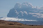
across the popular hiking trail between Skógar, south of the pass, and Þórsmörk, immediately to the north. On 14 April 2010 Eyjafjallajökull resumed erupting...
36 KB (3,262 words) - 01:27, 23 June 2024
Völvuskógur Þjórsárdalur (national forest) Þórðarstaðaskógur (national forest) Þórsmörk (national forest) Öskjuhlíð Icelandic Forest Service "Kort af þjóðskógum...
3 KB (259 words) - 13:57, 15 July 2022

plains at Iceland's south coast, near Þórsmörk. The Markarfljót takes its course first north, then west of Þórsmörk and finally empties into the Atlantic...
7 KB (545 words) - 17:26, 23 June 2024

they proceeded by Icelandic horse along the south coast to Bergþórshvoll, Þórsmörk, Geysir, Þingvellir, and then back to Reykjavík, where they departed back...
135 KB (16,687 words) - 07:59, 28 June 2024
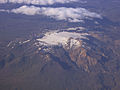
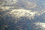
Thórsmörk glacial outwash plain...
36 KB (4,676 words) - 11:13, 11 February 2024
river, through the Emstrur plain and across the Fremri-Emstruá river to Þórsmörk, it covers a total of 55 km. The race has been held annually since 1997;...
13 KB (427 words) - 09:04, 27 January 2021

Eyjafjallajökull and Mýrdalsjökull in southern Iceland. The route between Skógar and Thórsmörk goes through this pass and is one of the most popular walking routes in...
5 KB (448 words) - 22:49, 22 January 2023

"Kuju : Geological Maps of Japan". Geological Survey of Japan, AIST. "Thórsmörk Ignimbrite(correlated to Ash Zone 2)". VOGRIPA. Retrieved 27 May 2024...
68 KB (1,153 words) - 19:06, 22 June 2024
about 8 km (5.0 mi) south of the glacier. Its eastern slopes abut the Þórsmörk ignimbrite.: 29 The western flank has a prominence near Austurdalur and...
10 KB (931 words) - 01:14, 9 July 2024
Heritage Sites Laugavegur: 80 km (50 mi) from Landmannalaugar to Skógar via Thórsmörk mountain ridge Grand Italian Trail (Sentiero Italia): nationwide trail...
35 KB (4,031 words) - 18:53, 16 May 2024

"Financial accounts". Hagstofa.is. p. 3. Retrieved 2015-11-10. "krpano - thorsmork". Vr-iceland.grandpano.sk. Retrieved 13 August 2018. "Tourism in Iceland...
13 KB (1,104 words) - 05:38, 4 June 2024
duo's songs "Heathens" and "Heavydirtysoul". The video was filmed in Thórsmörk, Iceland. On July 12, 2018, the music video for "Jumpsuit" surpassed "Heathens"...
24 KB (2,291 words) - 15:09, 6 July 2024
of 9 km2 (3.5 sq mi) and volume up to 0.4 km3 (0.096 cu mi). The Þórsmörk (Thorsmork) ignimbrite and widespread North Atlantic and Greenland II-RHY-1...
21 KB (2,335 words) - 17:08, 19 July 2024
5-km-wide caldera was formed during the eruption of the 54,000-year-old Thórsmörk Ignimbrite. It is capped by a glacier of 19 km2. Its highest peak is Ýmir...
220 KB (16,948 words) - 17:37, 19 July 2024
Garðabær. Grades K-3 are housed in a second building next door, called Thorsmork. The International School of Iceland offers two programs, or “streams...
11 KB (970 words) - 00:36, 16 March 2024