Ždánice may refer to places in the Czech Republic: Ždánice (Hodonín District), a town in the South Moravian Region Ždánice Forest, a mountain range named...
594 bytes (111 words) - 09:11, 7 September 2023

The Ždánice Forest (in Czech, Ždánický les; known in German as the Steinitzer Wald) is a mountain range and forest in the Czech Republic, geologically...
1 KB (180 words) - 17:31, 11 February 2021

Staré Ždánice is a municipality and village in Pardubice District in the Pardubice Region of the Czech Republic. It has about 700 inhabitants. "Population...
3 KB (77 words) - 09:09, 13 September 2024

inhabitants. Ždánice is located about 23 kilometres (14 mi) north of Hodonín and 31 km (19 mi) southeast of Brno. It lies mostly in the Ždánice Forest, only...
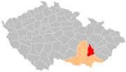
6 KB (343 words) - 11:51, 11 September 2024

Ždánice is a municipality and village in Kolín District in the Central Bohemian Region of the Czech Republic. It has about 400 inhabitants. "Population...
3 KB (78 words) - 11:33, 16 September 2024

Ždánice is a municipality and village in Žďár nad Sázavou District in the Vysočina Region of the Czech Republic. It has about 200 inhabitants. Ždánice...
4 KB (109 words) - 12:58, 21 August 2024
Rudolfov (2,559) Nové Sedlo (2,557) Chabařovice (2,551) Chýnov (2,551) Ždánice (2,539) Rokytnice nad Jizerou (2,533) Zbiroh (2,527) Nové Hrady (2,506)...
25 KB (2,178 words) - 07:14, 4 June 2024

lies in the Dyje–Svratka Valley and the southern part extends into the Ždánice Forest. The highest point is the hill Urban at 361 m (1,184 ft) above sea...
12 KB (1,084 words) - 04:36, 1 September 2024

Město Libavá Bärn 17,347 17,285 99.6% 28 0.2% 0 0.0% 34 0.2% Steinitz Ždánice Gaya 14,814 205 1.4% 14,567 98.3% 0 0.0% 42 0.3% Sternberg Šternberk Sternberg...
61 KB (1,992 words) - 10:16, 11 August 2024

Thaya-Schwarza Thalsenke, CZ: Dyjsko-svratecký úval) (CZ: Středomoravské Karpaty) Ždánice Forest (Ždánický les) Litenčice Hills (Litenčická pahorkatina) Chřiby Kyjov...
32 KB (2,939 words) - 20:48, 9 July 2024
Zlončice 582 Zlonín 1,331 Zlosyň 492 Zvánovice 588 Zvole 1,961 Zvoleněves 912 Ždánice 367 Želenice 214 Železná 322 Žilina 836 Žižice 762 Županovice 73 Total...
20 KB (165 words) - 19:50, 8 June 2024

and Slovakia. It is formed by the depression in the Western Carpathians (Ždánice Forest, Kyjov Hills and Mikulov Hills) in the west and Bílé Karpaty and...
4 KB (337 words) - 23:43, 16 July 2023

Věteřov - Vlkoš - Vnorovy - Vracov - Vřesovice - Žádovice - Žarošice - Ždánice - Želetice - Žeravice - Žeraviny Hodonín District borders Slovakia in the...
11 KB (713 words) - 10:11, 19 September 2024

in the Upper Oligocene to Badenian (Middle Miocene). The Silezian and Ždánice units were deformed in the Karpatian to Lower Badenian. The Moldavide Flysch...
9 KB (1,235 words) - 22:09, 4 January 2024

Srch 1,745 Srnojedy 787 Staré Hradiště 2,053 Staré Jesenčany 420 Staré Ždánice 728 Starý Mateřov 942 Stéblová 370 Stěžery 2,187 Stračov 317 Střezetice...
9 KB (317 words) - 08:56, 3 September 2024
Vyškov Gate (a strip between Drahany Highlands and Litenčice Hills), Ždánice Forest (south) and Dyje–Svratka Valley (small part in the west). The highest...
11 KB (659 words) - 06:01, 23 August 2024
Chateau Vyškov na Moravě Chateau Zbraslav Castle Znojmo Castle Ždánice - Palánek Castle Ždánice Chateau List of castles in the Czech Republic List of castles...
6 KB (487 words) - 21:07, 31 March 2023

Vlachovice - Vlkov - Vojnův Městec - Vysoké - Záblatí - Zadní Zhořec - Ždánice - Žďár nad Sázavou - Znětínek - Zubří - Zvole The landscape is rugged and...
15 KB (870 words) - 09:33, 20 September 2024
(Kutná Hora) Zbýšov (Vyškov) Zbytiny (Prachatice) Ždánice (town; Hodonín) Ždánice (Kolín) Ždánice (Žďár nad Sázavou) Ždánov (Domažlice) Žďár (Blansko)...
236 KB (17,724 words) - 10:51, 22 August 2024

Steinhübel: Kamenná Horka, p. of Krásná Lípa Steinige Höhe: Kamenáč Steinitz: Ždánice (Hodonín District) Steinitz: Uherský Ostroh Steinkirchen: Kamenný Újezd...
261 KB (29,422 words) - 03:19, 14 July 2024

shelter with two parish priests, Václav Kostiha and František Voneš, in Ždánice. However, several days later Pechal was contacted by a former resistance...
7 KB (658 words) - 07:19, 25 August 2024
sulphur-free, paraffin and paraffin-naphthenic oil. Uhřice and Kloboučky (in the Ždánice region) are the only oil deposits in this area. Three grades of oil were...
6 KB (789 words) - 07:17, 12 April 2024

territory), Mikulov Highlands (southwest), Dyje–Svratka Valley (west), Ždánice Forest (north) and Kyjov Hills (small part in the northeast). The highest...
11 KB (752 words) - 10:08, 19 September 2024

family and joined to the Ždánice estate. After the Battle of White Mountain, their properties were confiscated and the Ždánice estate with Násedlovice...
4 KB (183 words) - 08:39, 11 September 2024

territory lies in the Dyje–Svratka Valley, but it also extends into the Ždánice Forest range in the east and to the Lower Morava Valley in the south. The...
6 KB (413 words) - 08:52, 10 September 2024

(14 mi) north of Břeclav and 27 km (17 mi) south of Brno. It lies in the Ždánice Forest range. The highest point is the hill Holý vrch at 401 m (1,316 ft)...
5 KB (234 words) - 08:07, 10 September 2024

Brno. It lies in an agricultural landscape, which mostly belongs to the Ždánice Forest. The northwestern part of the municipal territory extends into the...
4 KB (219 words) - 13:15, 29 August 2024

(14 mi) north of Břeclav and 29 km (18 mi) south of Brno. It lies in the Ždánice Forest range. The highest point at 382 m (1,253 ft) above sea level. The...
5 KB (325 words) - 07:59, 10 September 2024

(Mikulovská vrchovina) IXA-1 81 263.4 550 (Děvín) Central Moravian Carpathians Ždánice Forest (Ždánický les) IXB-1 470 270.7 439 (U Slepice) Litenčice Hills (Litenčická...
17 KB (292 words) - 04:08, 24 July 2024

Vitice - Volárna - Vrátkov - Vrbčany - Žabonosy - Zalešany - Zásmuky - Ždánice - Žehuň - Žiželice The district is located in a agricultural and deforested...
10 KB (590 words) - 06:18, 23 August 2024