
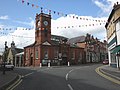
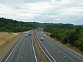
The A44 is a major road in the United Kingdom that runs from Oxford in southern England to Aberystwyth in west Wales. The original (1923) route of the...
19 KB (954 words) - 05:10, 23 July 2024
A44 may refer to : A44 road (Great Britain), a road connecting Oxford, England and Aberystwyth, Wales A44 motorway (Germany), a road connecting Aachen...
556 bytes (102 words) - 20:45, 11 March 2023

Mosalski, Ruth (4 November 2014). "The A44 between Llangurig and Aberystwyth is revealed as Wales' most dangerous road". walesonline. Retrieved 12 August...
70 KB (79 words) - 20:36, 17 September 2024
is a road in Powys, Wales, which connects with the A483 road, not far from the A470 road at Llanelwedd, Builth Wells and leads to the A44 road near Llanfihangel...
2 KB (319 words) - 13:20, 17 December 2023

takes the road alongside the River Wye into Builth Wells. The road continues to follow the Wye to the busy crossroads where it meets the A44 in the centre...
22 KB (1,935 words) - 00:21, 5 August 2024

the Cotswold Way, and can be reached by following this footpath from the A44 road at Fish Hill, or by a steep climb out of Broadway village. It is now the...
7 KB (687 words) - 21:00, 19 September 2024

Cambrian Mountains, and is located at the junction of the A470 road and the A44 road 13 miles (21 km) north of Builth Wells and 30 miles (48 km) east...
15 KB (1,649 words) - 06:41, 3 October 2024

of Mid Wales, approximately 12 miles (19 km) east of Aberystwyth on the A44 road. At the village's heart lies Yr Hen Bont (English: The Old Bridge), a steep...
2 KB (231 words) - 12:18, 13 September 2024

parish in the Arrow valley in Herefordshire, England. The village is on the A44 road about 6 miles (10 km) east of Kington and 7 miles (11 km) west of Leominster...
14 KB (1,642 words) - 15:26, 21 November 2023
shadow of Hergest Ridge, and on the River Arrow, where it is crossed by the A44 road. It is 19 miles (31 km) northwest of Hereford, the county town. Nearby...
28 KB (2,838 words) - 16:34, 29 September 2024

The Elvis Rock is a rock alongside the A44 in Powys, Wales, near its border with Ceredigion. It is one of the most well known pieces of graffiti in Wales...
2 KB (175 words) - 01:58, 5 October 2023

controversial wind farm project, is in the Cambrian Mountains, just south of the A44 road between Aberystwyth and Llangurig. The area was proposed as a national...
9 KB (957 words) - 00:45, 11 June 2024
Inventor of time travel lived here in 2189 Llandegley International Airport A44 road, between Crossgates and Cefnllys, Wales 52°16′27″N 3°19′35″W / 52.2742151°N...
12 KB (402 words) - 12:06, 26 July 2024
The A4, A44 and M4 are a collection of arterial routes in Sydney, New South Wales that connect the Inner West of Sydney with the outer western suburbs...
8 KB (652 words) - 07:44, 13 August 2024

The A44 motorway is a motorway in the Netherlands connecting the A4 with Wassenaar. The route continues as main road N44 towards The Hague, providing an...
4 KB (362 words) - 08:57, 26 August 2024

in the English midlands at the northern corner of a T junction on the A44 road, a mile and a half east of the small town of Moreton-in-Marsh (which has...
8 KB (686 words) - 14:23, 16 June 2024

/ 52.30139; -3.51139 in Rhayader near the junction of the A470 road and the A44 road and leads eventually to the A470 again at Llanbrynmair at 52°36′42″N...
2 KB (158 words) - 22:06, 8 June 2024

Chipping Norton the route became part of an extended A44. The A34 was diverted north from the Oxford Ring Road to the M40 along parts of the former routes of...
12 KB (999 words) - 08:48, 8 June 2024

on a stream that flows southwest to join the river. The A436 road, which links the A44 road in Oxfordshire with Stow-on-the-Wold, passes through the parish...
15 KB (1,678 words) - 15:03, 12 October 2024

Great Western Highway (redirect from A44 (Sydney))
the section of Great Western Highway/Parramatta Road between Strathfield and Haberfield was designated A44, replacing the previous A4 designation. Great...
57 KB (5,784 words) - 06:20, 13 August 2024

valley on the A44 road on the edge of the Radnor Forest, and is home to a church and two pubs. The A481 road from Builth joins the A44 near here. St Michael's...
2 KB (191 words) - 01:22, 24 February 2023
intersects with the A470) and Llandrindod Wells. It intersects with the A44 at Crossgates, just north of Llandrindod Wells, then continues to Newtown...
6 KB (478 words) - 15:22, 20 January 2024

Cambrian Mountains on Cefn Croes mountain, 573m (1,880 ft) south of the A44 road between Aberystwyth and Llangurig, in west Wales. The construction of the...
2 KB (121 words) - 01:36, 11 June 2024
and in a 1962 byelection. The so-called "Elvis Rock" graffito beside the A44 road in Ceredigion was originally written with the word "Ellis" by two of his...
5 KB (563 words) - 01:23, 1 September 2024
south of Plynlimon (Pumlumon), north of Pen y Garn, and just south of the A44 road. The mountain is classified as a HuMP, denoting its prominence. It is situated...
949 bytes (85 words) - 04:24, 11 June 2024

the River Frome. It is near the county border with Worcestershire on the A44 between Leominster and Worcester. Bromyard has a number of traditional half-timbered...
50 KB (6,199 words) - 13:18, 10 October 2024

lies in the district of Wychavon, half a mile from Worcester, along the A44 road. Spetchley contains Spetchley Park, a country mansion with extensive gardens...
2 KB (220 words) - 03:16, 7 January 2023

roads in zone 3 in Great Britain starting west of the A3 and south of the A4 (roads beginning with 3). Wikimedia Commons has media related to A roads...
54 KB (56 words) - 23:53, 18 August 2024

intended to attract park-and-ride traffic from the busy A34, A40 and A44 roads. Services to Oxford started on 11 December 2016. The station is part of...
15 KB (1,150 words) - 02:14, 27 August 2024

located 12.5 miles (20.1 km) northeast of Hereford. The village lies on the A44 road, 3 miles (4.8 km) from Bromyard and 8 miles (13 km) from Leominster. The...
5 KB (337 words) - 06:21, 26 February 2023