
Bhrigupanth (Hindi: भृगुपंत) is a mountain of Garhwal Himalaya in Uttarakhand, India. It stands majestically at 6772 meter 22218 feet. It is the 38th...
4 KB (419 words) - 19:02, 24 March 2024

Gangotri Group A photograph of Gangotri Group (including Bhrigupanth, Thalaysagar and Kedarnath) as viewed from Benog tibba, Mussorrie ( 30°28'36.56"N...
4 KB (312 words) - 20:24, 3 November 2019

Sumeru and Ghanohim are important. Four other glaciers, Maitri, Meru, Bhrigupanth and Manda drain into the river Bhagirathi. The total glacierized area...
11 KB (1,373 words) - 00:55, 4 June 2024
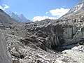
eastern side lies Bhrigupanth Bamak and Manda Bamak. Kedar Ganga emerges from Kedar bamak and joins Bhagirathi River near Gangotri. Bhrigupanth Bamak and Manda...
3 KB (394 words) - 16:27, 30 May 2024

II 6,242 metres (20,479 ft). It is located 6.6 km (4.1 mi) north of Bhrigupanth 6,772 metres (22,218 ft) and 9.6 km (6.0 mi) SW lies Jogin I 6,465 metres...
5 KB (608 words) - 10:34, 28 June 2024

is fed by the snowfall over Thalay Sagar (6,904 m), Meru (6,672 m), Bhrigupanth (6,772 m) and other surrounding peaks, and is the source of Kedar Ganga...
3 KB (193 words) - 07:35, 25 October 2023
79°30′30″E / 31.01417°N 79.50833°E / 31.01417; 79.50833 6,775 22,228 Kamet Bhrigupanth Garhwal Uttarkashi 30°52′50″N 79°00′10″E / 30.88056°N 79.00278°E /...
47 KB (306 words) - 12:38, 8 June 2024
and directly draining into Bhagirathi river Maitri 4,000 Meru 4,720 Bhrigupanth 3,720 Manda 3,880 Raktavarna and its Tributary Glaciers (TG) (A) Raktavarna...
21 KB (1,930 words) - 10:06, 28 November 2023
of Jogin II 6,342 metres (20,807 ft). Its nearest higher neighbor is Bhrigupanth 6,772 metres (22,218 ft). It is located 8.1 km (5.0 mi) NW of Shivling...
5 KB (620 words) - 19:45, 7 November 2022
4 km south of Manda II 6,568 metres (21,549 ft) and 2.8 km north of Bhrigupanth 6,772 metres (22,218 ft). It lies 6.6 km east of Jogin II 6,342 metres...
3 KB (452 words) - 23:23, 18 December 2022

this category. It lies 5.4 km east of Gangotri III and 7.4 km west of Bhrigupanth 6,772 metres (22,218 ft). It lies 2.2 km South of Jogin II. Its nearest...
5 KB (716 words) - 09:23, 27 May 2020
this category. It lies 6.2 km east of Gangotri III and 7 km west of Bhrigupanth 6,772 metres (22,218 ft). It lies 2.2 km north of Jogin I. Its nearest...
5 KB (609 words) - 09:17, 27 May 2020

called Annapurna: A Woman's Place. She led the first expedition to climb Bhrigupanth in the Indian Himalayas, leading a team of Indian and American women...
18 KB (1,780 words) - 12:54, 29 July 2024
led the first woman's climbs of Denali (1970), Annapurna (1978), and Bhrigupanth in the Indian Himalayas (1980). 1975, Eugenie Clark, American ichthyologist...
14 KB (1,271 words) - 23:55, 4 March 2024