
Canal Street is a major east–west street of over 1 mile (1.6 km) in Lower Manhattan, New York City, United States, running from East Broadway between...
11 KB (1,275 words) - 22:19, 12 October 2023

The Canal Street station is a New York City Subway station complex. It is located in the neighborhoods of Chinatown and SoHo in Manhattan and is shared...
153 KB (13,229 words) - 02:17, 22 August 2024
Louisiana Canal Street (Manhattan), New York City Canal Street station (New York City Subway), a station complex in the Chinatown neighborhood of Manhattan, consisting...
2 KB (347 words) - 18:47, 22 July 2023
BMT Broadway Line (redirect from Canal Street Subway)
passing under the northbound local track to the Manhattan Bridge. The tracks via Canal Street and the Manhattan Bridge were not intended to be connected to...
112 KB (10,426 words) - 12:22, 20 June 2024

The New York City borough of Manhattan contains 214 numbered east–west streets ranging from 1st to 228th, the majority of them designated in the Commissioners'...
62 KB (7,195 words) - 16:38, 7 June 2024

Tribeca (redirect from Beach Street (Manhattan))
is a neighborhood in Lower Manhattan in New York City. Its name is a syllabic abbreviation of "Triangle Below Canal Street". The "triangle" (more accurately...
102 KB (10,427 words) - 17:59, 20 July 2024
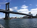
The Manhattan Bridge is a suspension bridge that crosses the East River in New York City, connecting Lower Manhattan at Canal Street with Downtown Brooklyn...
228 KB (23,080 words) - 17:34, 25 July 2024

Washington Street is a north–south street in the New York City borough of Manhattan. It runs in several distinct pieces, from its northernmost end at 14th...
8 KB (786 words) - 01:05, 6 April 2024

Broad Street is a north–south street in the Financial District of Lower Manhattan in New York City. Originally the Broad Canal in New Amsterdam, it stretches...
32 KB (3,403 words) - 00:21, 6 August 2024

Located at the intersection of Canal Street, Vestry Street, and Sixth Avenue (Avenue of the Americas) in Lower Manhattan, it is served by the A and E trains...
32 KB (2,820 words) - 02:17, 22 August 2024
SoHo, short for "South of Houston Street", is a neighborhood in Lower Manhattan, New York City. Since the 1970s, the neighborhood has been the location...
58 KB (6,158 words) - 15:14, 20 July 2024

Colonel Benjamin Forsyth. Forsyth Street's southernmost portion, south of Canal Street, runs parallel to the Manhattan Bridge in Chinatown. On the west...
3 KB (282 words) - 01:11, 12 January 2024

Old Chinatown of Manhattan lies along Mott, Pell, Doyer, Bayard, Elizabeth, Mulberry, Canal, and Bowery Streets, within Manhattan's Chinatown. Newer satellite...
165 KB (14,881 words) - 12:39, 3 August 2024

neighborhoods, from East 8th Street past West Houston Street to Canal Street. The street was previously called First Street and Clermont Street, but was renamed in...
2 KB (226 words) - 16:53, 28 May 2024

Square, and the Manhattan Bridge. Seward Park (on Canal and Essex Street) Confucius Plaza Agia Barbara (on Forsyth Street) Eldridge Street Synagogue (on...
3 KB (316 words) - 06:04, 15 May 2024
of 13th and 14th Streets by footbridges. Marble Hill was part of the northern tip of Manhattan Island, but the Harlem River Ship Canal, dug in 1895 to...
307 KB (30,780 words) - 00:05, 24 August 2024

Greenwich Street is a north–south street in the New York City borough of Manhattan. It extends from the intersection of Ninth Avenue and Gansevoort Street in...
16 KB (1,560 words) - 08:59, 21 June 2024

The Brooklyn Bridge–City Hall/Chambers Street station is a New York City Subway station complex in Lower Manhattan. The complex is served by trains of the...
135 KB (12,509 words) - 02:16, 22 August 2024

to Lower Manhattan are Canal Street, roughly half a mile north of Chambers Street, and 23rd Street, roughly half a mile north of 14th Street. Lower Manhattan's...
78 KB (7,669 words) - 08:49, 4 August 2024
Template:Attached KML/Houston Street KML is from Wikidata Houston Street (/ˈhaʊstən/ HOW-stən) is a major east–west thoroughfare in Lower Manhattan in New York City...
13 KB (1,210 words) - 10:47, 22 August 2024

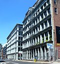
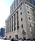
254–260 Canal Street, also known as the Bruce Building, is a building on the corner of Lafayette Street in the Chinatown neighborhood of Manhattan, New York...
4 KB (378 words) - 01:53, 15 July 2023

area above 96th Street. Midtown Manhattan is the area between 34th Street and 59th Street. Lower Manhattan is the area below 14th Street. West Side is the...
15 KB (459 words) - 07:28, 23 July 2024

Street is an east–west street in Lower Manhattan. It runs nearly the full width of Manhattan island, from Hudson Street in the west to Lewis Street in...
4 KB (450 words) - 19:35, 15 January 2024

(Manhattan) KML is from Wikidata Second Avenue is located on the East Side of the New York City borough of Manhattan extending from Houston Street at...
17 KB (1,564 words) - 07:30, 28 July 2024

J/Z (New York City Subway service) (redirect from 14 (Brooklyn–Manhattan Transit Corporation service))
"bullets", are colored brown since they use the BMT Nassau Street Line in Lower Manhattan. The J operates at all times while the Z, operating as its rush-hour...
59 KB (5,159 words) - 11:57, 14 August 2024

Pearl Street is a street in the Financial District in Lower Manhattan, running northeast from Battery Park to the Brooklyn Bridge with an interruption...
17 KB (1,638 words) - 20:51, 4 November 2023

West Side Highway (redirect from West Street (Manhattan))
State Route 9A (NY 9A), running from West 72nd Street along the Hudson River to the southern tip of Manhattan in New York City. It replaced the West Side...
45 KB (7,006 words) - 02:57, 22 July 2024
0073 Church Street and Trinity Place form a single northbound roadway in Lower Manhattan, New York City. Its northern end is at Canal Street and its southern...
18 KB (1,837 words) - 14:59, 25 March 2024

47th Street is an east–west running street between First Avenue and the West Side Highway in the borough of Manhattan in New York City. Traffic runs one...
16 KB (1,794 words) - 13:05, 21 August 2024

Bowery (redirect from The Bowery (Manhattan))
is a street and neighborhood in Lower Manhattan in New York City, United States. The street runs from Chatham Square at Park Row, Worth Street, and Mott...
50 KB (5,679 words) - 23:38, 8 July 2024