
Crown Range (redirect from Crown Range Road)
Eastburn Road the road twists and climbs up to the Crown Saddle, where a bronze plaque at the vista point claims that this historic summit, at 1076 m...
4 KB (506 words) - 10:48, 10 April 2024

Chiriaco Summit is a small unincorporated community and travel stop located along Interstate 10 in the Colorado Desert of Southern California. It lies...
12 KB (885 words) - 04:47, 31 July 2023

between the Waikato and Manawatū-Whanganui regions intersects the Desert Road at its summit, which at 1074m above sea level is the highest pass on the New...
5 KB (543 words) - 03:49, 26 February 2024
List of major junctions on New Zealand State Highway 1 (category Lists of roads in New Zealand)
493 Desert Road Summit 1,074 m (3,524 ft) 39°18′10″S 175°44′28″E / 39.3028005°S 175.7411987°E / -39.3028005; 175.7411987 (Desert Road Summit) Waiouru...
31 KB (34 words) - 10:47, 10 April 2024
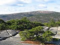
Cadillac Mountain (category Mount Desert Island)
located on Mount Desert Island, within Acadia National Park, in the U.S. state of Maine. With an elevation of 1,530 feet (470 meters), its summit is the highest...
7 KB (690 words) - 19:50, 12 May 2024

like the English common noun desert (/ˈdɛzərt/ DEZ-ərt). French explorer Samuel de Champlain's observation that the summits of the island's mountains were...
29 KB (3,425 words) - 19:25, 9 July 2024
Cajon Pass (redirect from Cajon Summit)
edge of the Mohave Desert, is a thick succession of sheets of gravel and sand extending far up the mountain sides and beyond the summit at Cajon (cah-hone')...
25 KB (2,876 words) - 04:21, 9 July 2024

Shaver's Well. Around 1950, he left Desert Center, living the rest of his days at his log cabin retreat near the summit of Santa Rosa Mountain. His sons...
26 KB (2,865 words) - 14:41, 28 January 2024

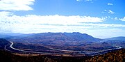
U.S. Route 50 in Nevada (redirect from The Loneliest Road in America)
Fallon area. The road narrows from four lanes to two and crosses remote terrain characterized by Basin and Range topography. The summits start out low and...
59 KB (4,937 words) - 08:28, 25 April 2024

Gulf War (redirect from Operations Desert Shield and Desert Storm)
key phases: Operation Desert Shield, which marked the military buildup from August 1990 to January 1991; and Operation Desert Storm, which began with...
251 KB (27,841 words) - 01:07, 11 July 2024

Tehachapi Pass (redirect from Tehachapi Summit)
refers to the narrowest part of the canyon on the eastern approach to the summit (as at San Gorgonio Pass), where the elevation is about 3,771 feet (1,149 m)...
6 KB (484 words) - 23:22, 24 March 2024

U.S. Route 395 in California (category Mojave Desert)
the Mojave Desert. While crossing the desert, the route clips the northeastern corner of Edwards Air Force Base. Just past the base, the road intersects...
53 KB (4,632 words) - 05:46, 6 May 2024

Desert greening is the process of afforestation or revegetation of deserts for ecological restoration (biodiversity), sustainable farming and forestry...
50 KB (5,728 words) - 11:13, 30 June 2024

2014-03-27. Johnson, Shea. "Iconic Summit Inn diner in Oak Hills reopens". Summit Inn Review | The Mojave Desert. Fodor's Restaurant Reviews. Retrieved...
10 KB (781 words) - 22:55, 23 April 2024

Umling La (section Chisumle-Demchok road)
Umling La or Umlung La is the highest paved road and mountain pass in the world, located in Ladakh, India, on the ridgeline between Koyul Lungpa and the...
4 KB (432 words) - 13:12, 10 July 2024

Nevada State Route 375 (redirect from Warm Springs Road)
mostly unoccupied desert terrain, with much of its alignment paralleling the northern edges of the Nellis Air Force Range. The road originally traversed...
20 KB (1,972 words) - 15:02, 27 May 2024

Rollins Pass (redirect from Boulder Wagon Road)
railroad-era dining hall foundation at the summit. The Metro-Goldwyn-Mayer 1925 silent film, The White Desert, starring Claire Windsor as Robinette McFarlane...
214 KB (19,010 words) - 05:04, 10 February 2024

U.S. Route 66 in California (redirect from National Old Trails Road in California)
area is desert; towns like Amboy originated as Atlantic and Pacific Railroad stops and were sustained by Route 66 traffic during the Mother Road's heyday...
25 KB (1,951 words) - 13:43, 4 April 2024

Chiriaco Summit, California, is a museum erected in tribute to General George S. Patton on the site of the entrance of Camp Young, part of the Desert Training...
9 KB (884 words) - 11:32, 10 February 2024
Mexican soldiers, Teofulio Summit became the route of the Sonora Road into the coastal region of Southern California. The Sonora Road reestablished land communications...
3 KB (350 words) - 04:33, 9 December 2023
Catalina Highway (category Infobox road temporary tracking category 1)
scientific facilities located near the summit of Mount Lemmon. Ascending from the desert floor in Tucson to near the summit of Mount Lemmon, the short highway...
12 KB (1,221 words) - 18:13, 19 November 2023
feet to a summit at 3270 feet (996 m) in the Gila Bend Mountains in the U.S. state of Arizona. Established in 1990 under the Arizona Desert Wilderness...
2 KB (155 words) - 00:20, 1 November 2021

Acadia National Park (category Mount Desert Island)
the Bubbles, Bubble Rock, Bubble Pond, Eagle Lake, and the side road to the summit of Cadillac Mountain. Some of the island's west side features include...
103 KB (9,868 words) - 07:09, 13 July 2024

Ridge Route (redirect from Reservoir Summit, California)
the old road runs through the Angeles National Forest, and passes many historical landmarks, including the National Forest Inn, Reservoir Summit, Kelly's...
34 KB (4,021 words) - 16:51, 5 April 2024

9,733 feet (2,967 m) above sea level, the summit of Steens Mountain is the highest point in the high desert. The broad fault-block mountain is characteristic...
38 KB (3,690 words) - 22:13, 13 June 2024

Mount San Antonio (category North American 3000 m summits)
commonly referred to as Mount Baldy or Old Baldy, is a 10,064 ft (3,068 m) summit in the San Gabriel Mountains on the border of Los Angeles and San Bernardino...
39 KB (4,554 words) - 22:18, 4 June 2024

Geography of Arizona (section Sonoran Desert)
in the Sonoran Desert. Northwestern Arizona contains part of the Mojave Desert, which is at a higher altitude than the Sonoran Desert. The boundaries...
25 KB (3,808 words) - 17:58, 6 January 2024

Rancho Mirage, California (category Populated places in the Colorado Desert)
low-density desert-resort community with resorts, golf courses, and country clubs within the Colorado Desert section of the Sonoran Desert. Nestled along...
85 KB (9,497 words) - 20:03, 14 May 2024
desert: wide valleys bordered by parallel mountain ranges generally oriented north–south. There are more than 33 peaks within the desert with summits...
49 KB (5,046 words) - 02:35, 19 June 2024

what is now the Mojave National Preserve in the Mojave Desert in the United States. This rough road stretched 147 miles (237 km) from Beale's Crossing (the...
21 KB (3,020 words) - 03:01, 31 May 2024