
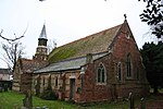
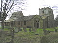
Donington on Bain is a village and civil parish in the East Lindsey district of Lincolnshire, England. The village is approximately 6 miles (10 km) south-west...
6 KB (473 words) - 08:45, 24 December 2022
Shropshire, England Donington on Bain, a village in Lindsey, Lincolnshire Donington le Heath, Leicestershire, England location of Donington le Heath Manor...
865 bytes (141 words) - 22:08, 9 February 2022

footpath, and flows through or past the villages of Burgh on Bain, Biscathorpe, Donington on Bain, Goulceby, Asterby and Hemingby before reaching the town...
11 KB (476 words) - 18:00, 3 September 2021

Donington railway station was a station in the village of Donington on Bain, Lincolnshire, England. The Great Northern Railway planned and built a branch...
3 KB (104 words) - 00:57, 24 February 2023
RAF Stenigot (category Coordinates on Wikidata)
former Second World War radar station situated at Stenigot, near Donington on Bain, Lincolnshire. It was built in 1938 by Blaw-Knox as part of the Chain...
6 KB (345 words) - 22:59, 26 September 2023

Louth and Horncastle (UK Parliament constituency) (category Coordinates on Wikidata)
District of East Lindsey wards of Alford, Chapel St Leonards, Coningsby, Donington on Bain, Fotherby, Grimoldby, Halton Holegate, Hogsthorpe, Holton le Clay...
23 KB (938 words) - 14:27, 12 July 2024

Gainsborough and Horncastle (UK Parliament constituency) (category Coordinates on Wikidata)
West Lindsey, and the District of East Lindsey wards of Binbrook, Donington on Bain, Horncastle, Roughton, Woodhall Spa, and Wragby. "'Gainsborough and...
6 KB (171 words) - 17:18, 22 December 2023
Louth to Bardney Line (category Coordinates on Wikidata)
(later Donington on Bain), Withcall (in 1882) and Hallington. The original service was five trains each way on weekdays only, reduced to four on 1 January...
10 KB (1,364 words) - 10:12, 15 December 2023

Round barrow (category Commons category link is on Wikidata)
Donnington-on-Bain, near Donington on Bain Folk Moot & Butt Mound, near Silk Willoughby Fordington Barrows, near Ulceby Grim's Mound, near Burgh on Bain Hagworthingham...
5 KB (544 words) - 08:33, 3 February 2023

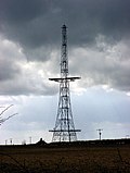
Belmont transmitting station (category Coordinates on Wikidata)
facility next to the B1225, 1 mile (1.6 km) west of the village of Donington on Bain in the civil parish of South Willingham, near Market Rasen and Louth...
23 KB (1,603 words) - 22:49, 18 April 2024
Campbell - guitar (on disc 1) Craig Goldy - guitar (on disc 2) Claude Schnell - keyboards Jimmy Bain - bass Vinny Appice - drums "DIO: 'Donington UK: Live 1983...
10 KB (558 words) - 22:56, 4 May 2024
School, Ashby de la Launde The Donington Cowley Primary School, Donington The Donington-on-Bain School, Donington on Bain Dunholme St Chad's CE Primary...
21 KB (2,123 words) - 11:27, 27 September 2023

New York, Lincolnshire (category Coordinates on Wikidata)
Lincolnshire, England, in the parish of Wildmore in the Lincolnshire Fens on the B1192 road near Coningsby, 11+1⁄2 miles (18.5 km) north of Boston. At...
3 KB (164 words) - 04:37, 30 May 2024

Kirkby on Bain is a village and civil parish in the East Lindsey district of Lincolnshire, England. It lies on the River Bain between Horncastle and Coningsby...
7 KB (524 words) - 17:28, 27 June 2024

Louth, Lincolnshire (category Coordinates on Wikidata)
(until its height was reduced in 2010), is in the nearby village of Donington on Bain, 5 miles (8 km) west of the town. Louth will be the eventual southern...
53 KB (5,649 words) - 22:18, 1 June 2024
Derrythorpe, Derthorpe, Dexthorpe, Digby, Doddington, Dogdyke, Donington, Donington on Bain, Donna Nook, Dorrington, Dowsby, Dragonby, Driby, Drinsey Nook...
24 KB (1,557 words) - 22:44, 26 January 2024

Salmonby (category Coordinates on Wikidata)
photographs, remaining: In 1971 the civil parish had a population of 58. On 1 April 1987 the parish was abolished and merged with Tetford. The village...
5 KB (402 words) - 21:21, 22 November 2023
Cleatham Round barrow Manton Scheduled Ancient Monument Donington on Bain Round barrow Donington on Bain Scheduled Ancient Monument Folk Moot Round barrow Silk...
7 KB (42 words) - 19:54, 23 April 2024
New Bolingbroke (category Coordinates on Wikidata)
Covenham St Bartholomew Covenham St Mary Croft Cumberworth Dalby Donington on Bain East Barkwith East Keal East Kirkby Eastville Edlington with Wispington...
5 KB (400 words) - 23:03, 13 June 2024

Stenigot (category Coordinates on Wikidata)
town of Louth, and 1 mile (1.6 km) south-east from the village of Donington on Bain. It includes the hamlet of Cold Harbour. The population is included...
4 KB (308 words) - 04:49, 12 August 2021

Bolingbroke, Lincolnshire (category Coordinates on Wikidata)
to the south-west by the Quaternary post-glacial sands and gravels of the Bain Valley formation. The parish boundary is complex, but can be summarised as...
14 KB (1,277 words) - 10:45, 13 June 2024

Saltfleetby (category Coordinates on Wikidata)
village and civil parish in the East Lindsey district of Lincolnshire, England on the coast of the North Sea, approximately 7 miles (11 km) east from Louth...
5 KB (401 words) - 15:39, 27 August 2023
Mablethorpe (category Coordinates on Wikidata)
population of 3,611. On 1 April 1974 the parish was changed to form "Mablethorpe and Sutton". The population including nearby Sutton-on-Sea was 12,531 at...
21 KB (1,977 words) - 19:05, 21 May 2024
guyed mast FM-/TV-transmission 351.5 m (1,153 ft) 1965 United Kingdom Donington on Bain, Lincolnshire 53°20′9.07″N 0°10′19.11″W / 53.3358528°N 0.1719750°W...
23 KB (226 words) - 01:05, 8 April 2024

Westville, Lincolnshire (category Coordinates on Wikidata)
of the West Fen in 1812, in 1866 Westville became a separate civil parish, on 1 April 2005 the parish was abolished and merged with Frithville to form "Frithville...
3 KB (237 words) - 19:42, 31 May 2024

Horncastle (category Coordinates on Wikidata)
remains. Although fortified, Horncastle was not on any important Roman roads, which suggests that the River Bain was the principal route of access to it. Roman...
35 KB (3,317 words) - 23:40, 12 July 2024
BBC Radio Lincolnshire (category Coordinates on Wikidata)
signal on 94.9 FM comes from the Belmont transmitting station near Donington on Bain in the north of the county, which, until the height reduction carried...
14 KB (1,431 words) - 13:25, 27 February 2024
Minting (category Coordinates on Wikidata)
Covenham St Bartholomew Covenham St Mary Croft Cumberworth Dalby Donington on Bain East Barkwith East Keal East Kirkby Eastville Edlington with Wispington...
3 KB (176 words) - 20:40, 30 August 2022

Sutton-on-Sea (originally Sutton in the Marsh or Sutton le Marsh) is a seaside town in the East Lindsey district of Lincolnshire, England, beside a long...
11 KB (1,152 words) - 21:33, 29 January 2024

Ingoldmells (category Coordinates on Wikidata)
resort in the East Lindsey district of Lincolnshire, England. It is situated on the A52, and 3 miles (5 km) north from the resort town of Skegness. Most housing...
10 KB (1,041 words) - 07:28, 3 September 2023