
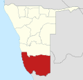
question marks, boxes, or other symbols. Hardap is one of the fourteen regions of Namibia, its capital is Mariental. Hardap contains the municipality of Mariental...
14 KB (1,176 words) - 01:40, 12 July 2024
Hardap may refer to: Hardap Region, one of the thirteen regions of Namibia Hardap Dam, the largest dam in Namibia This disambiguation page lists articles...
152 bytes (52 words) - 17:23, 28 December 2019

The Hardap Dam is a dam close to Mariental in the Hardap Region of central Namibia. Built in 1963 while Namibia was under South African occupation, the...
5 KB (491 words) - 03:36, 18 March 2024

530 Tses ǁKaras 1,365 Gibeon Hardap 2,631 Gochas Hardap 1,163 Kalkrand Hardap 1,238 Stampriet Hardap 1,947 Maltahöhe Hardap 2,379 Divundu Kavango East 746...
24 KB (1,321 words) - 17:40, 21 July 2024

Welcoming sign of the Burgsdorf farm in Hardap...
176 KB (16,363 words) - 16:53, 2 September 2024

Sesriem (category Populated places in the Hardap Region)
Sesriem is a small settlement in the Namib Desert, in the Hardap Region of Namibia, close to the southern end of the Naukluft Mountains. It is especially...
6 KB (289 words) - 21:51, 14 July 2023
Postal codes in Namibia (section HARDAP REGION)
After 28 years without a postal code system in Namibia, the national postal service provider NamPost introduced new postal codes in December 2018. They...
8 KB (671 words) - 17:46, 10 August 2024

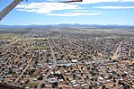
Mariental, Namibia (category Populated places in the Hardap Region)
administrative capital of the Hardap Region in an area which has long been a centre for the Nama people. It lies near the Hardap Dam, the second largest reservoir...
12 KB (993 words) - 04:02, 13 April 2024
Derm, Namibia (category Populated places in the Hardap Region)
Derm is a hamlet in the Hardap Region of central Namibia, on Route M-41 at its intersection with routes D-1328 and C-25. It is 13 kilometres (8 mi) east...
5 KB (169 words) - 14:10, 15 September 2023

Namibia. It is 650 km long, flowing from the Naukluft Mountains 150 km to the Hardap Dam near Mariental. From there the flow is entirely blocked, all further...
3 KB (148 words) - 19:36, 24 March 2024
Rehoboth, Namibia (category Populated places in the Hardap Region)
newly formed Landless People's Movement (LPM) which scored well all over Hardap. LPM gained 2,468 votes and two seats in the town council, followed by SWAPO...
17 KB (1,448 words) - 03:33, 9 April 2024
the Nossob River in the Northern Cape province of South Africa and the Hardap Region of Namibia. 22°39′05″S 17°17′10″E / 22.6514°S 17.286°E / -22.6514;...
637 bytes (81 words) - 18:52, 1 September 2024

Stampriet (category Populated places in the Hardap Region)
Stampriet is a village in Hardap Region, Namibia. It is located 64 km north-east of Mariental and 1,177 metres (3,862 ft) above sea level, in a barren...
9 KB (624 words) - 05:17, 10 April 2024

Waterberg Plateau Park Cape Cross Seal Reserve Daan Viljoen Game Reserve Hardap Recreation Resort Gross Barmen Hot Springs Popa Game Park South West Nature...
2 KB (157 words) - 07:36, 5 April 2022

23.433°S 14.450°E / -23.433; 14.450 (Namibia) Namibia Erongo, Khomas, Hardap, Khomas (again), and Omaheke regions 23°26′S 20°0′E / 23.433°S 20.000°E...
20 KB (1,747 words) - 16:00, 22 August 2024

the north. To the east is the Omaheke region, while in the south is the Hardap region. The region is characterized by its hilly countrysize and many valleys...
15 KB (1,295 words) - 03:36, 8 July 2024
3rd National Council of Namibia (section Hardap Region)
Members of the 3rd National Council of Namibia, which lasts from 2004 - 2009. The chairperson is Asser Kuveri Kapere of the South West Africa People's...
2 KB (159 words) - 07:45, 30 April 2023

the former Schuckmannsburg. Especially in the south, in the regions of Hardap and ǁKaras, many place names are German or Afrikaans. Examples include Keetmanshoop...
14 KB (1,419 words) - 22:56, 10 June 2024
Northern Cape Province of South Africa. Domestically, it borders only the Hardap Region, to the north. As of 2020, ǁKharas had 56,352 registered voters....
14 KB (1,384 words) - 10:07, 4 August 2024

The core of this area is situated near the village of Gibeon in Namibia's Hardap Region. About 100–150 different fragments have been collected over time...
5 KB (498 words) - 22:15, 3 September 2024

4% (2001 Census) to 10.4% (2011 Census). The major concentrations are in Hardap (41.0%), ǁKaras (36.1%), Erongo (20.5%), Khomas (18.5%), Omaheke (10.0%)...
115 KB (8,948 words) - 17:32, 2 September 2024
Katrina Hanse-Himarwa (category People from Hardap Region)
2004 local elections for the SWAPO party she was appointed governor of Hardap Region, a position she held until 2015. Hanse-Himarwa was one of the eight...
8 KB (583 words) - 12:44, 25 August 2024
politician, minister of education, arts, and culture (2015–2019), governor of Hardap (2004–2015), cancer. Jacoby Jones, 40, American football player (Baltimore...
185 KB (13,619 words) - 12:07, 4 September 2024

3,726 5,132 6,938 Usakos Erongo 2,926 3,583 5,094 Aranos Hardap 3,683 5,493 Rehoboth Hardap 21,439 21,308 28,843 40,788 Rundu Kavango East 19,366 36,964...
9 KB (411 words) - 14:57, 4 June 2024

Hendrik Witbooi (Nama chief) (category People from Hardap Region)
This article contains click symbols from the Khoekhoe language. Without proper rendering support, you may see question marks, boxes, or other symbols....
10 KB (1,097 words) - 16:48, 30 August 2024

Population People per km2 Average Household Size Erongo 63,539 240,206 3.8 3.1 Hardap 109,781 106,680 1.0 3.6 Kavango East 23,988 218,421 9.1 5.3 Kavango West...
5 KB (205 words) - 17:29, 3 September 2024

valleys of the border rivers Oranje, Kunene, and Okavango, and also at the Hardap Irrigation Scheme. As of 2020, the Minister of Agriculture, Water, and Land...
9 KB (956 words) - 03:35, 23 June 2024
Katutura, Windhoek, Khomas Region A. A. Denk Memorial School, Kalkrand, Hardap Region Acacia High School, Windhoek Academia Secondary School, Khomasdal...
54 KB (4,515 words) - 07:30, 5 August 2024

western Kweneng districts in Botswana; southern Omaheke and northeastern Hardap regions in Namibia. Native speakers 2,500 (2011) Language family Tuu Taa–Lower...
34 KB (3,070 words) - 13:12, 22 July 2024
The Hardap Recreation Resort (also known as Hardap Nature Reserve) is a National Park located in southern Namibia. It was proclaimed in 1968 and measures...
5 KB (526 words) - 18:20, 4 May 2023