
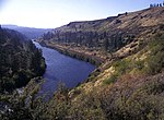
The Naches River is a tributary of the Yakima River in central Washington in the United States. Beginning as the Little Naches River, it is about 75 miles...
9 KB (792 words) - 13:30, 17 May 2024
Naches is a name used in Washington state, U.S.A. The name may refer to: Naches, Washington Naches River Naches Pass Naches Peak Naches Trail Natchez...
310 bytes (61 words) - 14:31, 23 March 2021

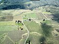
Naches is a town in Yakima County, Washington, United States. The population was 1,084 at the 2020 census. The town is located along the Naches River...
12 KB (923 words) - 20:27, 29 July 2024

named Little Naches Road, the highway exits the Wenatchee National Forest and enters Naches. The byway ends at US 12 in Naches near the Naches Selah Canal...
34 KB (2,891 words) - 20:06, 20 August 2024
Mad River Mashel River McAleer Creek Methow River Middle Fork Snoqualmie River Miller River Muddy River Naches River Napeequa River Naselle River Nason...
15 KB (1,143 words) - 18:32, 19 September 2024
to take the new "People's Road" over Naches Pass, they followed a route up the Naches and Little Naches Rivers to the mountains, leaving the prairies...
11 KB (1,578 words) - 14:21, 27 March 2024

mouth (Naches River, WA). Dams are listed in order from headwaters (Confluence of Middle Fork Willamette River and Coast Fork Willamette River, OR/WA)...
145 KB (5,874 words) - 04:41, 7 June 2024

Nahchísh-ħlama (″People along the Roaring Water, i.e. Naches River″), lived along the Tieton and Naches rivers (the latter meaning ″roaring, rough or turbulent...
24 KB (2,950 words) - 03:52, 1 July 2024

The Tieton River is a tributary of the Naches River, in Yakima County, Washington in the United States. The Tieton River begins in two forks, the North...
5 KB (302 words) - 13:30, 17 May 2024
northern and southern sections is the confluence of the Naches and Yakima Rivers. The Yakima River provides irrigation for the dry but fertile land in the...
14 KB (1,240 words) - 01:31, 17 May 2024

Naches Trail (also spelled Nachess) is a historic trail in the U.S. state of Washington. It extends from the Naches River in Eastern Washington in the...
3 KB (376 words) - 19:58, 20 February 2022

to the east. The name Naches Peak was proposed by the Yakima Chamber of Commerce and approved by Asahel Curtis in 1927. The Naches Peak Loop Trail is a...
5 KB (392 words) - 03:34, 13 April 2024

The Bumping River is a tributary of the Naches River, in Washington in the United States. It flows down the east side of the Cascade Range, through Wenatchee...
5 KB (274 words) - 13:30, 17 May 2024

extend to the Columbia River, and there has been a suggestion that the Tacoma Fault may connect with the White River—Naches River fault on the east side...
178 KB (20,732 words) - 11:43, 13 September 2024

alternative was Naches Pass, which with the addition of a short tunnel would be much lower (and easier to keep open in winter). The Naches Pass plan is still...
6 KB (674 words) - 04:08, 28 October 2022

Yakima, Washington (category Populated places on the Yakima River)
and also used for both fishing and recreation. The Naches River, a tributary of the Yakima River, forms the northern border of the city. The Yakima Greenway...
63 KB (5,179 words) - 04:57, 20 September 2024

Yakima County, Washington (section Major rivers)
Rattlesnake Hills Horse Heaven Hills Yakima River Columbia River Naches River Tieton River Bumping River American River Wenatchee National Forest (part) Gifford...
24 KB (2,041 words) - 21:51, 26 April 2024

it land. Tieton is located near the confluence of the Tieton River with the Naches River. This climatic region is typified by large seasonal temperature...
11 KB (936 words) - 02:11, 11 March 2024

1996 Pacific Northwest floods (category Columbia River)
in three days, causing the Yakima River to rise. Similar values were recorded near the headwaters of the Naches River, a tributary of the Yakima, with...
17 KB (1,550 words) - 04:29, 26 April 2024

Snake underground: Big Lost River (Idaho) Little Lost River (Idaho) Amon Creek (Washington) Naches River (Washington) Tieton River (Washington) Tieton Dam...
23 KB (1,609 words) - 19:52, 22 March 2024
the Naches Formation is an unconformity as seend in th Summit Creek Sandstone [~43 to 37 Ma] in the areas from White Pass east to the Naches River. In...
6 KB (658 words) - 00:33, 5 August 2024

along the Tieton River (in Yakama: Táitin) hence territory of the Nahchísh-ħlama, a Yakama/Lower Yakama band along the Naches River and had strong linguistic...
22 KB (2,724 words) - 15:35, 11 October 2024
of rivers in the United States. Nabesna River - Alaska Naches River - Washington Nacimiento River - California Naknek River - Alaska Namekagon River -...
7 KB (650 words) - 15:52, 2 May 2024
to cross, including Puget Sound, Hood Canal, the Columbia River and numerous smaller rivers and creeks. It has experienced a number of bridge failures...
15 KB (588 words) - 20:32, 31 July 2024
domain. "Naches Heights Wine". Wine-Searcher. May 20, 2013. Archived from the original on October 20, 2018. Retrieved April 19, 2024. "Naches Heights is...
8 KB (621 words) - 00:55, 17 May 2024

the pass to follow the Bumping River and Naches River to a point near Naches. East of the mouth of the American River, this replaced part of State Road...
48 KB (4,553 words) - 05:36, 26 August 2024

median of Interstate 82 (I-82), its parent route, as it crosses the Naches River. SR 823 was established by the state government in 1984, running from...
19 KB (1,891 words) - 00:54, 25 September 2024
Company Interurban Railroad, Naches River Bridge Extant Pegram truss 1907 1985 Yakima Valley Transportation Company Naches River Yakima Yakima 46°37′41″N...
27 KB (114 words) - 19:52, 25 May 2024
approximately 35 miles northwest of Yakima in the Nile Valley adjacent to the Naches River in the Nile Valley, near the mouth of Rattlesnake Creek. The community...
4 KB (196 words) - 06:55, 10 February 2024

WA-13-F, "Yakima Valley Transportation Company Interurban Railroad, Naches River Bridge", 7 photos, 1 photo caption page HAER No. WA-13-G, "Yakima Valley...
11 KB (1,161 words) - 19:32, 10 June 2024